
Alb (Upper Rhine)
| Alb | ||
 Position of the Alb highlighted |
||
| Data | ||
| Water code | EN : 2312 | |
| location |
|
|
| River system | Rhine | |
| Drain over | Rhine → North Sea | |
| origin |
Confluence Menzenschwander / Bernauer Alb : about 3.3 kmnordwestlich the center of St. Blaise in the gallows Matt 47 ° 46 '52 " N , 8 ° 5' 47" O source Menzenschwander Alb : at Seebuck 47 ° 51 '42 " N , 8 ° 1 ′ 37 ″ O |
|
| Source height | Confluence Menzenschwander / Bernauer Alb : | |
| muzzle | at Albbruck in the Rhine Coordinates: 47 ° 35 '3 " N , 8 ° 7' 43" E 47 ° 35 '3 " N , 8 ° 7' 43" E |
|
| Mouth height | approx. 308 m above sea level NHN | |
| Height difference | approx. 1039 m | |
| Bottom slope | approx. 24 ‰ | |
| length | 43.6 km from the source of the left upper reaches of the Menzenschwander Alb |
|
| Catchment area | 242.989 km² | |
| Discharge at the St. Blasien A Eo gauge : 97 km² Location: 25 km above the mouth |
NNQ (10/27/1985) MNQ 1981-2010 MQ 1981-2010 Mq 1981-2010 |
180 l / s 520 l / s 4.02 m³ / s 41.4 l / (s km²) |
| Discharge at the mouth (natural discharges) A Eo : 241.2 km² |
MNQ MQ Mq |
4.76 m³ / s 8.6 m³ / s 35.7 l / (s km²) |
| Reservoirs flowed through | Albstausee | |
 View from the Spießhorn eastwards into the valley of the Menzenschwander Alb |
||
The Alb is a river in the southern Black Forest . It arises from two source rivers , the Menzenschwander Alb and the Bernauer Alb , flows in a southerly direction and flows into the Upper Rhine for almost 44 km from the source of its left upper course, and from the confluence of its two upper courses over 32 km at Albbruck . With an average natural water flow of 8.6 m³ / s, the Alb is the second largest right tributary of the High Rhine.
Earlier this Rhine tributary was to distinguish it from the from the Northern Black Forest to the current tapered only on his upper section of the Rhine Alb also Hauensteiner Alb called.
etymology
The name Alb possibly goes back to the Indo-European * albhos for white or river . The river valley formed the border between the former Albgau and Breisgau .
geography
course
Source rivers
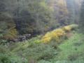
The headwaters of the Menzenschwander Alb are on the southern slope of the Feldberg massif in the Breisgau-Hochschwarzwald district, while that of the Bernauer Alb is on the southern slope of the Herzogenhorn . After both streams have flowed through their eponymous places, Menzenschwand and Bernau, in a south-easterly direction, they unite after less than 14 and more than 11 kilometers at the Glashofsäge to form the Alb.
Both valleys have valley floors widened by the Ice Age glaciers of the former Feldberg glacier , which are characterized by grassland management due to their altitude of 900 m. The Bernauer Valley is a wide basin that is structured by small valley steps, moraine walls , boggy depressions, small brook gorges and cusp-like rock heads. The hamlets and individual farms of the village are scattered a little above the bottom of the valley, which is prone to frost . The glacial forms in the narrow valley of the Menzenschwander Alb are even more striking . The steep terminal moraine wall of the Menzenschwander Kluse is well known . Below, the Alb falls in waterfalls through a small gorge to the silting plain of a lake basin carved out by the former Krunkelbach valley glacier. Both source rivers reach their confluence in gorges on the level of another former lake basin, which stretches over 4 km to the small town of St. Blasien .
- Bernauer Alb and Menzenschwander Alb

The high valley of the Bernauer Alb towards the southern roof of the Black Forest
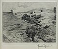
Typical brook landscape of the Bernauer Alb, drawing by Hans Thoma, 1898

Waterfalls in Maria Loch above the Menzenschwander Kluse
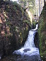
Waterfalls in the gorge of the Menzenschwander Alb


Middle course
The valley area occupied by the local position of St. Blasien is characterized by the classical dome of the St. Blasien cathedral . At the abandoned St. Blasien monastery , the Alb was branched into canals from 1813 for the use of water power by the Badische rifle factory and the St. Blasien spinning mill . Below the town center, the Alb forms the waterfall on the Tusculum (place name based on the Roman Tusculum ). Then the Alb, like almost all of the neighboring Black Forest rivers to the east, changes its course, kinking by about 60 degrees, in a southerly direction, which is related to the increasing gradient towards the Upper Rhine as a result of tectonic earth crust movements since the Pliocene . The former continues to the southeast passing valley is nearly 200 feet higher in the saddle of houses still visible, especially because part of the mighty here to 300 meters during the last ice ages Albtal glacier through this valley by transfluency the Valley of the Schwarza overflowed.
Below the Talknic, the river is dammed in the Alb basin (on average 18 hectares, length of the dam wall: around 80 meters) and most of its water flow is diverted to the Schwarzabruck reservoir of the Schluchseewerk . From an average discharge of a good 4.2 m³ / s, 0.1 m³ / s still remain below the dam.
The Alb now flows through a meadow-lined, 200 to 400 meter wide valley in which the towns of Schlageten and Immeneich are located. The valley is no longer accompanied by narrow, wooded mountain ridges, but by the undulating high plateaus of the Hotzenwald around the communities of Dachsberg and Höchenschwand , divided by moors and rocky peaks . Mining was carried out around Urberg and Bildstein until modern times. At the Niedermühle was the end of the tongue of the Alb glacier, which at 27 kilometers was the longest Black Forest glacier during the Würm cold time . Here the valley narrows abruptly and leaves no space for settlements on the remaining 14 kilometers to Albbruck.
- Middle reaches of the Alb
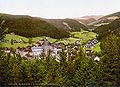
St. Blasien and the upper Alb valley around 1900

The Alb in St. Blasien near St. Blasien Cathedral
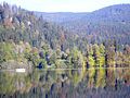
The Albstausee below St. Blasien

The Alb valley above the gorge near Niedermühle


Alb canyon
The slope of the Alb increases sharply in the gorges and the river forces its way through several gorge-like passages and blocked sections such as the well-known Teufelsküche . This is one of the largest glacier pots in the Black Forest, created by the former Albtal glacier. From the right, the Ibach and Höllbach flow into the Alb, also flowing in gorges, the latter with two waterfalls . Because of the narrowness of the gorge, the road runs up to 80 meters higher on the left bank. At the widening of the valley at the sawmill Tiefenstein , the Schildbach and Steinbach flow into two sides. Here there are two castle ruins and granite quarries halfway up.
The narrowest and steepest section, about 4 kilometers long, begins a little below. Here, too, the Alb continued to flow on a different route, namely through today's Mühlbachtal, which flows into the Rhine at Hauenstein . The old flow path was blocked by meltwater and glacier deposits during an older ice age, whereupon the Alb found a new route to the Rhine. Since then, it has cut the “new” gorge into the granite rock.
This narrowest section of the gorge is not passable without equipment, but here the water flow is mostly low due to renewed water drainage. If the water level is sufficient, the Alb is probably the most difficult white water in Germany among canoeists . In this section the road runs up to 100 meters above the river and crosses five short tunnels cut through the rock walls, which is why the road was formerly known as the Axenstraße of the Black Forest . Since Whitsun 2015, Albtalstrasse L 154 between Görwihl-Tiefenstein and Albbruck-Hohenfels has been closed until further notice due to the risk of rock falls. After protests by the affected communities, it was announced in early 2018 that the state would pay the cost of rock securing. An initial report spoke of around three million euros for securing the slope along the four-kilometer stretch. To this day, residents are still resisting the closure of the Alb valley route. From the Hohenfels group of houses (gastronomy, vantage point) the road to Albbruck gradually falls back to river level. Here, shortly before the mouth of the Alb into the Upper Rhine, is the Hohenfels hydropower plant , built in 1898 by the former Albbruck paper mill . Due to the water drainage through power plants, only 3.3 m³ / s flow into the Upper Rhine today at the confluence point of naturally 8.6 cubic meters per second.
- Upper and lower Alb canyon
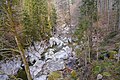
Devil's Kitchen in the upper gorge
Widening of the Alb gorge near Tiefenstein

One of five tunnels in the upper canyon wall, colored photo, before 1900

The Alb Gorge above Albbruck, engraving, 1841


_IM_HAUENSTEINER_ALBTHAL.jpg)
Catchment area
The Alb has a catchment area of 243 km² which , in terms of natural space , is almost entirely part of the Black Forest ; only about one kilometer before its mouth does it change to the neighboring natural area of the High Rhine Valley .
Tributaries and lakes
List of tributaries and ![]() lakes from the origin to the mouth. Length of water, lake area, catchment area and altitude according to the corresponding layers on the LUBW online map. Other sources for the information are noted.
lakes from the origin to the mouth. Length of water, lake area, catchment area and altitude according to the corresponding layers on the LUBW online map. Other sources for the information are noted.
Confluence of the Alb at about 786 m above sea level. NHN about 3.3 km northwest of the center of St. Blasien at the beginning of the Galgenmatt . The Alb initially flows southeast.
- Menzenschwander Alb , left upper reaches from the northwest, 13.7 km and 31.8 km². Arises at about 1435 m above sea level. NHN on the eastern slope of the Seebuck ( 1449.3 m above sea level ), which is near the Feldbeck .
- Bernauer Alb , right upper reaches from the west-northwest, 11.3 km and 37.0 km². Arises at about 1335 m above sea level. NHN on the southwest slope of the Herzogenhorn ( 1415.6 m above sea level ).
- Pulverbächle , from the right and south-southwest to about 780 m above sea level. NHN on the Galgenmatt , 2.4 km and approx. 2.0 km². Arises at about 1010 m above sea level. NHN on the northern slope of the Ahornkopf ( 1055.6 m above sea level ).
- Neuhäuserbächle , from the left and northeast to about 776 m above sea level. NHN in the Galgenmatt , 3.5 km and approx. 3.6 km². Arises at about 1135 m above sea level. NHN between Habsberg ( 1,275 m above sea level ) and Unterhabsberg under the Krummenkreuz near Schluchsser Weiler Muchenland.
- Game reserve , from the left and north-northeast to about 770 m above sea level. NHN at the beginning of the valley sports grounds in front of St. Blasien, 1.2 km and approx. 0.8 km². Arises at about 1045 m above sea level. NHN am Sattel between Breitenstein and Bötzberg ( 1215.8 m above sea level ).
- Steinbächle or Steinenbächle , from the right and west to about 760 m above sea level. NHN at the monastery in St. Blasien, 7.9 km and 12.9 km². Arises at least about 1040 m above sea level. NHN east of the Rüttewaldkopf.
- Windbergbächle , from the left and north to about 753 m above sea level. NHN in eastern St. Blasien, 3.1 km and 3.7 km². Rises at about 1090 m above sea level. NHN on the Wittemle saddle east of the Bötzberg.
-
Schönenbach , from the left and north to about 745 m above sea level. NHN towards the end of St. Blasien, 1.5 km and 0.9 km². Rises at about 1005 m above sea level. NHN between Kuhberg and Glaserkopf .
After this inflow, the Alb swings quickly to the right to the south-south-west run until the beginning of the next. -
 Flows through at 736.5 m above sea level. NHN which also Albsee lake called Albbecken , ha about 19.3.
 - Lehnernbächle , from the left and northeast in the Alb basin at the residential area Im Hüttlebuck of St. Blasien, 0.7 km and approx. 1.0 km². Arises at about 842 m above sea level. NHN west of the summit of Goldebühl from houses .
- Moosbach , from the left and total north-northeast in the Alb basin to Im Hüttlebuck on the Seeweitung, 3.3 km and 2.4 km². Arises at about 1045 m above sea level. NHN north-northwest of houses between Glaserkopf and Gießbacher Kopf .
- Steigwaldbach , from the left and southeast in the Albsee, 1.1 km and about 0.8 km² .. Arises at about 940 m above sea level. NHN in the Steigwald northwest of Höchenschwand .
- Glockenbächle , from the right and a total of about west-southwest in the Albsee, 2.3 km and 1.9 km². Arises at about 989 m above sea level. NHN in the Schwandwald east-northeast of Dachsberg (southern Black Forest) -Rüttewies.
- Wolfsbrunnenbächle , from the left and east to about 700 m above sea level. NHN across from the campsite before Dachsberg-Oberkutterau, 0.5 km and over 0.1 km². Arises at about 940 m above sea level. NHN .
- Schwemmwiesbächle , from the left and east to about 693 m above sea level. NHN opposite Oberkutterau, 0.6 km and over 0.2 km². Arises at about 940 m above sea level. NHN west of Höchenschwand.
- Ruhbächle , from the left and northeast to about 687 m above sea level. NHN a little before St. Blasien-Unterkutterau, 0.8 km and approx. 1.2 km². Arises at about 905 m above sea level. NHN west-southwest of Höchenschwand.
- Moosbach , from the right and a total of northwest to about 683 m above sea level. NHN in St. Blasien-Unterkutterau, 1.8 km and 0.9 km². Arises at about 960 m above sea level. NHN on the southern edge of Dachsberg-Inner-Urberg.
- Langwiesbach , from the left and south-east to about 655 m above sea level. NHN in St. Blasien-Niedingen a few meters before the next, 1.3 km and about 0.9 km². Arises at about 873 m above sea level. NHN west-northwest of Höchenschwand-Oberweschnegg.
- Höllenbächle , from the right and northwest to about 655 m above sea level. NHN in St. Blasien-Niedingen, 4.3 km on the entire Schmidebach → Mühlebächle → Höllenbächle and 6.6 km². The Schmidebach arises at about 979 m above sea level. NHN southwest of Dachsberg-Ruchenschwand.
- Lehenwiesbächle , from the left and northeast to over 640 m above sea level. NHN across from St. Blasien-Schlageten. Doubtful, it could be a left branch of the Langwiesbach if it exists.
- Stampfbächle , from the right and west-northwest to 639.4 m above sea level. NHN in St. Blasien- Schlageten , 4.0 km and 3.1 km². Arises at about 977 m above sea level. NHN east of the saddle between Bühl and Rütte An den four ways northwest of Dachsberg-Ennersbach.
- Hirtenwiesbach , from the left and east to about 639 m above sea level. NHN a few meters after the previous one, 0.9 km and approx. 0.8 km². Arises at about 810 m above sea level. NHN northwest of Höchenschwand-Tiefenhäuser.
- Rotenmättlebach , from the right and northwest to about 630 m above sea level. NHN opposite the northern St. Blasien-Immeneich, 1.3 km and approx. 1.1 km². Arises at about 845 m above sea level. NHN northeast of Dachsberg-Wolpadingen in Tannholz .
- Möslebach , from the left and northeast to less than 617.3 m above sea level. NHN to Immeneich, 1.6 km and approx. 1.6 km². Arises at about 825 m above sea level. NHN southwest of Tiefenhäuser.
- (Bach from the Happinger Halde ), from the right and north-northeast to about 615 m above sea level. NHN across from a group of houses between Immeneich and St. Blasien-Niedermühle, 1.0 km and approx. 0.9 km². Arises at about 760 m above sea level. NHN im Gewann Im Kochbrunnen southeast of Wolpadingen.
- Sägebächle , from the left and northeast to about 606 m above sea level. NHN shortly before Niedermühle, approx. 1.6 km and approx. 1.9 km². Arises at about 763 m above sea level. NHN southwest of Bonndorf in the Black Forest -Brunnadern on the edge of the forest.
- (Mühlkanal), from the right and north to about 603 m above sea level. NHN near Sankt Blasien-Niedermühle, 1.0 km and about 0.8 km². Goes to about 612 m above sea level beforehand . NHN to the right and finally takes a ravine stream down from Dachsberg-Happingen. Previously, large parts of the area were thickened or filled.
- Gündlisbach , from the right and northwest to about 590 m above sea level. NHN north-east below Dachsberg- Wilfingen , 1.2 km and approx. 0.8 km². Arises at about 748 m above sea level. NHN northeast of the Wilfinger sports field.
- (Bach from the Bantlisloch ), from the left and east to below 590 m above sea level. NHN east of Wilfingen, 0.8 km and approx. 0.5 km². Arises at about 715 m above sea level. NHN .
- Ibach , from the right and north-northwest to about 545 m above sea level. NHN south of Wilfingen, 14.8 km and 41.4 km². Arises at about 1075 m above sea level. NHN in the nature reserve Kohlhütte-Lampenschweine west-northwest of Ibach .
- Altbächle , from the right and northwest to a little over 520 m above sea level. NHN , 1.8 km in the open and about 2.2 km². Arises at about 645 m above sea level. NHN northeast of Görwihl -Burg. Close to the mouth of the almost equally long Haustenbächle .
- Höllbach , from the right and northwest to about 504 m above sea level. NHN east of Görwihl, 9.1 km and 13.4 km². Arises at about 955 m above sea level. NHN in the clearing Zenonmättle north of Görwihl- Engelschwand .
- Steimelbach , from the right and northwest to over 490 m above sea level. NHN southeast of Görwihl, 1.3 km and approx. 0.6 km². Arises at about 710 m above sea level. NHN on the southern edge of Görwihl at the tributary of the long Vorderen Wühre in a short upper course from the village. The artificial Vordere Wühre is a branch of the Eschenbach running to the Höllbach, which itself is fed somewhat beforehand by the artificial Hinteren Wühre from the Höllbach, and it also partly drains back into the Höllbach via a branch; the catchment area cannot therefore be clearly delineated. See also Wuhr .
- Steinbach , from the left and northeast to 442.8 m above sea level. NHN on the saw before Görwihl- Tiefenstein , 9.0 km and 19.5 km². Arises at about 727 m above sea level. NHN near Weilheim - Remetschwiel .
- Lochmühlebach , from the right and northwest to about 435 m above sea level. NHN near Tiefenstein, 7.2 km on the Stellenbach / Stellebächle → Langmattbächle → Schildbach → Lochmühlebach and 14.5 km². Arises as Stellenbach / Stellebächle at about 834 m above sea level. NHN east of Herrischried - Hogschür .
- Rumplisbach , from the right and a total of west-northwest to less than 420 m above sea level. NHN , 1.8 km and about 1.1 km². Arises at about 465 m above sea level. NHN on the southeastern edge of Görwihl-Niederwihl.
- Fluhmattbach , on the lower reaches also Rickenbach , from the left and northwest to 339.9 m above sea level. NHN northwest of Albbruck , 3.4 km and approx. 3.5 km². Arises at about 540 m above sea level. NHN on the southern edge of Albbruck-Etzwihl and the Rickenbach waterfalls plunge down into the Alb.
Mouth of the Alb from the right and finally northwest to about 308 m above sea level. NHN near Albbruck immediately after the return of the power station canal into the Upper Rhine . The Alb is 32.4 km long from the confluence of its two upper reaches, and 43.6 km from the source of its left upper reaches Menzenschwander Alb and has a catchment area of 243.0 km².
tourism
In the summer of 2017, the 83.3 km long Albsteig Black Forest premium long-distance hiking trail was opened along both source rivers to the mouth.
Individual evidence
LUBW
Official online waterway map with a suitable section and the layers used here: Course and catchment area of the Alb
General introduction without default settings and layers: State Institute for the Environment Baden-Württemberg (LUBW) ( notes )
- ↑ a b c d e Height according to the contour line image on the background layer topographic map .
- ↑ a b c Length according to the waterway network layer ( AWGN ) .
- ↑ a b catchment area after the layer aggregated areas 04 .
- ↑ Lake area after the layer standing waters .
- ↑ Catchment area measured on the background layer topographic map .
- ↑ a b catchment area after the layer aggregated areas 05 .
- ↑ a b c d e f g h i Catchment area according to the basic catchment area layer (AWGN) .
- ↑ Length according to the waterway network layer ( AWGN ) , supplemented by an initial section not taken into account on the waterway map, which was measured on the topographic map background layer .
- ↑ a b Catchment area summed up from the sub-catchment areas according to the basic catchment area layer (AWGN) .
- ↑ length after the layer water body name .
Other evidence
- ^ Flood forecast center , State Institute for the Environment Baden-Württemberg
- ↑ a b c Geoportal Baden-Württemberg: LUBW service flowing waters - discharge parameters ( memento from December 28, 2017 in the Internet Archive )
- ↑ Josef Haas: White water pearls . Constance 1980, p. 25.
- ↑ Susanne Ehmann and Hannes Schuster (text), Falko Wehr (video): Waldshut district: L 154: Rock falls in the Alb valley: a road dies here. Badische Zeitung, May 18, 2016, accessed on May 18, 2016 .
- ↑ Michael Krug: Land pays for Albtalstrasse - Südwest - Badische Zeitung. Badische Zeitung, January 26, 2018, accessed on January 26, 2018 .
- ↑ The residents of the diversion in the Albbruck district of Buch are resisting the closure of the Albtal route - Albbruck - Hochrhein. Südkurier, February 27, 2020, accessed on July 28, 2020 .
- ^ Website of the Karl Group ( Memento from February 25, 2014 in the Internet Archive )
- ↑ Günther Reichelt : Geographical land survey: The natural spatial units on sheet 185 Freiburg i. Br. Federal Institute for Regional Studies, Bad Godesberg 1964. → Online map (PDF; 3.7 MB)
- ↑ Albsteig Black Forest - The hiking trail along the Alb from Albbruck in the Rhine Valley to the Feldberg. Retrieved July 28, 2017 .
literature
- Rudolf Metz , geological studies of the Hotzenwald. With excursions, especially in its old mining areas. Schauenburg, Lahr 1980, ISBN 3-7946-0174-2 .