
Bernau in the Black Forest
| coat of arms | Germany map | |
|---|---|---|

|
Coordinates: 47 ° 48 ' N , 8 ° 2' E |
|
| Basic data | ||
| State : | Baden-Württemberg | |
| Administrative region : | Freiburg | |
| County : | Waldshut | |
| Height : | 893 m above sea level NHN | |
| Area : | 38.04 km 2 | |
| Residents: | 1982 (Dec. 31, 2018) | |
| Population density : | 52 inhabitants per km 2 | |
| Postal code : | 79872 | |
| Area code : | 07675 | |
| License plate : | WT | |
| Community key : | 08 3 37 013 | |
| LOCODE : | DE UIS | |
| Address of the municipal administration: |
Rathausstrasse 18 79872 Bernau in the Black Forest |
|
| Website : | ||
| Mayor : | Alexander Schönemann | |
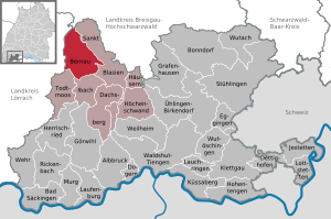
| Location of the municipality of Bernau in the Black Forest in the district of Waldshut | ||
  |
||

Bernau in the Black Forest is a municipality in the district of Waldshut in Baden-Württemberg .
geography
location
Bernau is located in a high valley in the southern Black Forest , south of the Feldberg and west of the Schluchsee . The municipality includes the valley of the Bernauer Alb, a source brook of the Alb , and extends from 800 meters above sea level to the 1415 meter high Herzogenhorn .
Neighboring communities
The municipality borders in the north on the municipality Feldberg , in the east on Menzenschwand / town of St. Blasien , in the south on Ibach , in the southwest on Todtmoos and in the west on Präg and Gschwend / town Todtnau in the district of Lörrach .
Community structure
The municipality of Bernau in the Black Forest includes the municipality parts Altenrond, Dorf mit Goldbach and Poche, Hof, Innerlehen, Riggenbach with Schwendele, Gaß, Kaiserhaus, Weierle, Oberlehen and Unterlehen.
climate
The annual precipitation is 1,919 mm. The precipitation is in the top percent of the measuring points of the German Weather Service . Over 99% indicate lower values. The driest month is September; most precipitation falls in December. In the wettest month there is about 1.9 times as much rain as in the driest month. The seasonal fluctuations in precipitation are in the upper third. In more than 95% of all places, the monthly precipitation fluctuates less. The temperatures are also quite cool at −2.5 ° C in January and 13.9 ° C in July, and in the morning the temperatures in Bernau are usually lower than on the Feldberg. The place is one of the snowiest in the Black Forest. Here the snow was almost two meters high in the winter of 2006.
|
Monthly average temperatures and precipitation for Bernau (928 m)
|
history

Settlement of today's municipality began in the late 11th century with the clearing and construction of farms by lay brothers from the St. Blasien monastery . The first documentary mention was made in 1157 on the occasion of the inauguration of a chapel in the district of Hof. With the secularization of the St. Blasien Monastery in 1806, the centuries-long rule of the monastery ended and at the same time the affiliation to Upper Austria , the place came to the newly created Grand Duchy of Baden .
In 1922, together with Holzwarenwerke Präg GmbH, the municipality built the Wacht electrical power station, which at that time supplied the woodworks and all residents of the municipality with electrical energy. In 1934, four independent municipalities in the Bernau Valley, Bernau-Innerlehen (with Riggenbach and Schwendele), Hof, Bernau-Dorf with Goldbach and Bernau-Ausserlehen (with Kaiserhaus, Altenrond, Oberlehen, Gaß, Unterlehen and Weierle) were combined to form the municipality of Bernau. Since then, the community has remained largely unchanged, even after the Baden-Württemberg regional reform in the 1970s. The name was changed to Bernau in the Black Forest on January 1, 1999.
politics
Municipal council
The municipal council in Bernau has 10 members. The municipal council consists of the elected voluntary councilors and the mayor as chairman. The mayor is entitled to vote in the municipal council. The local elections on May 26, 2019 brought the following result (with comparative figures from the previous two elections):
| Party / list | 2019 | 2014 | 2009 | |
| Citizens for Bernau | 40.9% - 4 seats | 41.8% - 4 seats | 4 seats | |
| Free voters | 38.8% - 4 seats | 36.1% - 4 seats | 3 seats | |
| CDU | 20.2% - 2 seats | 22.1% - 2 seats | 3 seats | |
| voter turnout | 71.1% | 67.3% | 70.8% |
mayor
- - 1986: Albert Schmidt
- 1986 - 2002: Heinz-Walter Kistler
- 2002 - 2018: Rolf Schmidt
- since 2018: Alexander Schönemann
Culture and sights


Museums
- The Hans-Thoma-Kunstmuseum shows paintings, graphics and other works as well as documents by Hans Thoma . In addition, the museum presents works by the respective Hans Thoma Prize winners and by Karl Hauptmann .
- The Resenhof local history museum , set up in a high Black Forest farm built in 1789, provides an insight into the living and working world of people in the Bernau high valley in the 19th century.
Sports
Almost 100 kilometers of well signposted hiking trails open up the 900 meter high and eight kilometer long high valley for hikers. The fans of Nordic walking are offered specially marked routes and mountain bikers will find routes of almost any level of difficulty. A flight school offers courses in paragliding .
Almost everything is possible in winter sports too , downhill, slalom, snowboard and tobogganing. Four ski lifts and a professional ski school run by the German Association of Ski Instructors are available to fans of alpine sports . For cross-country skiers there are several groomed trails , depending on the snow conditions up to 32 kilometers in length.
The FC Bernau football club, the SZ Bernau ski guild and the TC Bernau tennis club exist in the village. In winter, the dog sled race with international participation takes place regularly in Bernau .
Cultural associations
As of January 2020 In Bernau, citizens are organized in many cultural associations
- The accordion group - currently not active
- The choral society "Liederkranz Bernau" (since 1863) with around 15 singers
- The gospel choir "Voices - Los!" (since 1999) with approx. 30 singers
- The Guggenmusik "Gugge-Dubel" (since 1986) with approx. 70 members
- The children's u. Youth costume group
- The church choir (since 1838) with around 40 singers
- The amateur theater group "Hans-Thoma-Bühne" (since 1970)
- The Bernau Music Association (since 1864) with around 70 musicians
- The music club Bernau Ausertal (since 1906) with around 60 musicians
- The fools guild "Der Schniidesl" (since 1965)
- The traditional costume group with around 20 dancers
Economy and Infrastructure
The Bernau people traditionally lived from agriculture , forestry and wood processing. Wood carving in particular has a long tradition. Initially, utensils such as wooden spoons, wooden vessels, chip baskets and boxes were manufactured mainly in the winter months. Later, wooden toys and craft items added. However, there were and still are some wood turners in the Bernauer Valley. In 1940 there were around seven wood turners and today (2020) there are still two wood turners. These produce individual items (cans, candle / lamp stands, ...) by hand. But furniture parts (table legs, railing rungs, ...) are also manufactured industrially.
The sometimes extreme and erosion-prone slopes made agriculture difficult, not very productive and practically impossible to mechanize. Structural change began early on, in the 1930s, and this continued increasingly after the Second World War - away from agriculture and towards tourism . The location of the southern Black Forest, which was guaranteed to have snow until 2010, allowed an almost year-round tourist season. The first ski lift was put into operation in 1960 , today (2020) there are still five lifts in two ski areas.
Personalities
sons and daughters of the town
- Hans Thoma (1839–1924), painter and graphic artist, was born in Oberlehen, grew up there and was made an honorary citizen of Bernau in 1909.
- Ernst Koepfer (1878–1954), ski pioneer and founder of the Karl Köpfer Söhne company
Individual evidence
- ↑ State Statistical Office Baden-Württemberg - Population by nationality and gender on December 31, 2018 (CSV file) ( help on this ).
- ^ The state of Baden-Württemberg. Official description by district and municipality. Volume VI: Freiburg region Kohlhammer, Stuttgart 1982, ISBN 3-17-007174-2 . Pp. 1012-1013
- ↑ http://www.klimadiagramme.de
- ↑ StBA: Changes in the municipalities in Germany, see 1999
- ↑ Hans Thoma stage with a refreshing comedy. In: Badische Zeitung. July 26, 2001, accessed February 28, 2020 .
- ↑ About the panorama kiosk and other visions. In: Badische Zeitung. July 26, 2001, accessed February 28, 2020 .
- ^ Alpine skiing in Bernau in the Black Forest. Retrieved March 26, 2019 .
- ↑ ski-koepfer.de: Ski Köpfer , accessed on February 25, 2012
Web links

Albbruck | Bad Säckingen | Bernau in the Black Forest | Bonndorf in the Black Forest | Dachsberg | Dettighofen | Dogern | Eggingen | Görwihl | Grafenhausen | Houses | Herrischried | Höchenschwand | Hohentengen am Hochrhein | Ibach | Jestetten | Klettgau | Küssaberg | Leek rings | Laufenburg | Lottstetten | Murg | Rickenbach | St. Blasien | Stühlingen | Todtmoos | Ühlingen-Birkendorf | Waldshut-Tiengen | Weir | Weilheim | Wutach | Wutöschingen