Schluchsee
| Schluchsee | |||||||
|---|---|---|---|---|---|---|---|
| Schluchsee (seen from Aha) | |||||||
|
|||||||
|
|
|||||||
| Coordinates | 47 ° 49 '17 " N , 8 ° 9' 10" E | ||||||
| Data on the structure | |||||||
| Construction time: | 1929-1932 | ||||||
| Height above valley floor: | 35 m | ||||||
| Height above foundation level : | 63.5 m | ||||||
| Height of the structure crown: | 931.5 m | ||||||
| Building volume: | 124 000 m³ | ||||||
| Crown length: | 250 m | ||||||
| Crown width: | 3.7 m | ||||||
| Data on the reservoir | |||||||
| Altitude (at congestion destination ) | 930 m | ||||||
| Water surface | 5.14 km² | ||||||
| Reservoir length | 7.5 km | ||||||
| Reservoir width | 1.4 km | ||||||
| Storage space | 108 000 000 m³ | ||||||
| Total storage space : | 114.3 million m³ | ||||||
| Catchment area | 72.78 km² | ||||||
| Design flood : | 139.8 m³ / s | ||||||
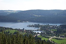
The Schluchsee is a reservoir in the municipality of Schluchsee near St. Blasien in the Breisgau-Hochschwarzwald district in Baden-Württemberg . It is located southeast of Lake Titisee and is the largest lake in the Black Forest .
The lake has also served as a tributary to the Schluchseewerk's pumped storage power station since the 1960s . In addition to a natural inflow, the lake is filled with water from the Rhine via various power plant levels.
Surname
In the Alemannic dialects of the region, the name of the lake is Schluech [ʃluˑəχs] or Schlues [ʃluˑəs] . The historical evidence also shows a diphthong : 983 lacus Sluochse , 1095 Schluochsee , 1125 predium Sluocse , 1312 the sê ze Sluoze . The name cannot come from mhd. Slûch 'hose' (Alemannic Schluuch ), as often claimed , since in this case there would be no diphthong in today's dialect and historical sources. Albert Krieger derives the name from the Middle High German sluocht 'Schlucht'. But this interpretation is not certain either.
location

The Schluchsee was originally a glacial lake of the Feldberg glacier , the level of which was around 30 meters below that of today's lake, which was only created by the damming of the Schwarza . Today it is 7.3 kilometers long and 1.4 kilometers wide in the northwest - southeast direction, the deepest point on the bottom is 61 meters below the lake surface.
The Schluchsee is part of the Schluchsee work group of the Schluchseewerk , a series of reservoirs of different heights that are connected by pumping stations. The group of works extends from houses to Waldshut . The Schluchsee is the upper basin of the Häuser pumped storage power plant . This power plant feeds an average of 100 megawatts into the power grid. In addition to the naturally flowing Schwarza or Ahabach and over the Windgälleweiher the upper reaches of the Wutach, Seegraben and Haslach , water from the Rhine near Waldshut is also fed into the basin through pumping stations.
The Schluchsee has a storage target of 930 m above sea level. NN and is thus the highest reservoir lake in Germany. It is even higher at 1048 m above sea level. NN is the storage target of the Hornberg basin, the upper basin of the Wehr pumped storage plant , but this has no dam.
Well-known places around the Schluchsee are on its northeast side, including the main town of the Schluchsee municipality a little below the center of the lake and its districts Aha in the upper, northwestern lake area and Seebrugg on the dam. The Dreiseenbahn , the extended end of the Höllentalbahn , runs from the Titisee train station along the northern shore of the lake to the Seebrugg terminus.
history
The 63.5 meter high dam was built between 1929 and 1932. To build this concrete gravity dam with a high specific weight , the natural lake first had to be lowered by 13 meters. For this purpose, a tunnel was blasted into the rock in 1930. A dugout canoe was also found, an examination of which it has now been possible to prove that the Schluchsee was already being used around the year 650 . The find was first stored in the Freiburg Augustinian museum and in the Adelhausermuseum (ethnological museum) and can now be viewed in the Archaeological State Museum in Konstanz-Petershausen .
On the south-western slope of the valley above the boat landing stage, granite was extracted for the inlet structure during the construction work in the quarry .
The rumor persists that the Schluchsee was covered with peat during the Second World War to protect the dam wall from bombing. In fact, the Schluchseetorf comes from two moor areas that adjoined the Urschluchsee before it was dammed. In the event of strong water fluctuations, peat islands can be observed to rise to the surface of the water and drift towards the dam, as most recently at the beginning of 2017.
On August 29, 1983, a major revision of the dam and the tunnel system began with the lowering of the lake. It took about 5 weeks to lower the water to the level of the original lake. As a result, the usual swimming, sea fishing and sailing had to pause. The rare event attracted many visitors; For the first time in a long time, rudiments of previously flooded buildings became visible again. The old Poststrasse also reappeared and was used by carriages.
More recently, there has been an increasing number of conflicts of interest between the Schluchseewerk and the Schluchsee community about the lake's water level in summer. While the Schluchseewerk is interested in the most advantageous economic use of the backwater, which is also accompanied by a sometimes sharp lowering of the lake level , the municipality fears that tourists will stay away if the lake is deep for a long time in the summer and reveals rather unsightly bank areas. But also the sometimes high water level and the fact that there are hardly any banks left cause discomfort among local users and tourists.
In the winter of 2013/14 the water level was massively lowered. The drained water was needed to generate electricity, as the solar power is usually less than usual at this time of year. In addition, the low water level meant that checks on the dam and drain could be carried out. In the district of Aha the old school building became visible again due to the lowering of the level. In June 2014 the water level had returned to normal.
On March 9, 2017, the usage permit for the Schluchseewerk expired. The process of applying for a new application to the Freiburg Regional Council was still ongoing at the time. There was a conflict with the community. The Schluchseewerk wanted to be able to lower the water level of the lake, the bottom of which is 888 meters above sea level, two meters more than before to 923 meters. This would make the shoreline about ten meters wider horizontally, which would be detrimental for anglers, sailors and bathers. When the usage permit expired, the regional council issued a permit for continued operation until the new usage agreement is legally binding. In January 2018, the regional council approved operation for another 60 years and set the minimum water level for the summer at 924 meters, with the exception of 923 meters on thirty days and 922 meters on ten days. Cumulative over three years it is 90 days 923 and 30 days 922 meters. Schluchseewerk AG is not satisfied with the result and is considering legal action against this decision.
icing
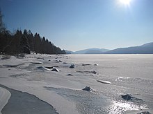
Since the water level in the reservoir fluctuates and water is supplied from deeper and thus warmer rivers, it is difficult to freeze over in winter. Entering the ice is strictly forbidden. However, the flat west end sometimes ices over so much that the cover bears. Traditionally, ice fishermen come here in winter to pierce the ice cover and catch fish.
tourism
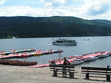
Because of the altitude, the water is relatively cool even in summer. The Schluchsee is particularly popular with bathers and sailors. In contrast to the Titisee, it has easily accessible banks almost everywhere, which is why the Schluchsee is heavily frequented in summer. It is a popular leisure destination for the wider area - beyond the Swiss border. On the forest side people bathe naked.
There is a diving center for diving in the Schluchsee in the Seebrugg station building .
The Schluchsee is surrounded by a variety of hiking trails. The whole lake can be hiked around, this 18-kilometer tour is largely flat and suitable for prams. From May to October, the hikes can be combined with trips on the excursion ship MS Schluchsee .
The 30.45 meter high Riesenbühl tower on the Riesenbühl ( 1097 m , north of the village of Schluchsee) overlooks the largest part of the lake.
Trivia
The Schluchsee became famous nationwide under the name "Schlucksee" because the German national soccer team set up their training camp there in 1982 in preparation for the World Cup in Spain . Individual players took full advantage of the freedoms that national coach Jupp Derwall gave them . Alcohol, card games and other escapades cast a bad light on the later vice world champions.
See also
Individual evidence
- ↑ The Schluchsee in the Black Forest. Retrieved July 24, 2019 .
- ↑ Stuttgarter Nachrichten, Stuttgart Germany: Energy generation at Schluchsee: The level and the exceptions. Retrieved July 24, 2019 .
- ↑ a b c Baden dictionary , Volume IV, p. 622 f.
- ↑ See e.g. B. Development planning for Schluchsee and the southern Black Forest. Project report. University of Technology, Faculty of Architecture and Design, Master’s degree in Urban Planning. Edited by Philipp Englert and Dennis Lakemann. Stuttgart, January 2006, p. 9.
- ^ Topographic dictionary of the Grand Duchy of Baden. Edited by Albert Krieger. 2nd edition, Heidelberg 1904-1905; Volume 2, p. 866.
- ^ Report in the Freiburger Zeitung of September 29, 1930
- ^ Friedbert Zapf: Schluchsee: Phenomenon of the Schluchseetorfs (I): On the Schluchsee, peat islands drift to the dam wall. Badische Zeitung, March 8, 2017, accessed on March 13, 2017 .
- ^ The Schluchsee as a moonscape , Badische Zeitung, March 7, 2014, accessed on March 16, 2014.
- ↑ Review: When the Schluchsee was lowered 40 meters , Badische Zeitung, September 28, 2013, accessed on October 2, 2015.
- ↑ Schluchseewerk needs water for electricity - community worries about tourism sighted on August 18, 2010.
- ↑ Ute Aschendorf, Ralf Morys: Schluchsee: Hochschwarzwald: Fish farmers concerned: Schluchsee has extremely little water , Badische Zeitung, March 5, 2014, accessed on March 16, 2014.
- ↑ Wulf Rüskamp: Southwest: Tourism vs. Industry: What's next with Schluchsee? Badische Zeitung, May 30, 2016, accessed on May 30, 2016 .
- ↑ Julia Gross: Schluchsee: Approval for the transition. Badische Zeitung, March 17, 2017, accessed on May 9, 2017 .
- ↑ Wulf Rüskamp: The Schluchsee is allowed to continue to supply electricity. Badische Zeitung, January 17, 2018, accessed on January 17, 2018 .
- ↑ Wulf Rüskamp: Compromise to operate the Schluchsee as a pumped storage facility. Badische Zeitung, January 17, 2018, accessed on January 17, 2018 .
- ↑ Press release from Schluchseewerk AG, Laufenburg , accessed on February 6, 2018
- ↑ Schluchsee diving area | Schluchsee diving center. (No longer available online.) Archived from the original on January 18, 2015 ; accessed on March 22, 2014 .
- ↑ The Riesenbuehlturm on riesenbuehlturm.de.


