Weir power plant
| Weir power plant | ||
|---|---|---|
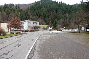
| Company premises at the lower basin of the Wehr power plant | ||
| location | ||
|
|
||
| Coordinates | 47 ° 39 '12 " N , 7 ° 56' 32" E | |
| country |
|
|
| place | Weir | |
| Waters | Upper basin: Hornberg basin Lower basin: weir basin |
|
| power plant | ||
| owner | Schluchseewerk AG | |
| operator | Schluchseewerk AG | |
| construction time | 1968-1976 | |
| technology | ||
| Bottleneck performance | Turbines: 910 megawatts Pumps: 980 megawatts megawatts |
|
| Expansion flow | 160 m³ / s | |
| Turbines | 4 machine sets with 227.5 MW turbine and 245 MW pump output Francis Bauart , Escher-Wyss / Voith | |
| Others | ||
| Website | www.schluchseewerk.de | |
The Wehr power plant is a pumped storage power plant in Wehr in the south of Baden-Württemberg . Its pumping capacity is 980 MW and its generator capacity is 910 MW. This makes it the most powerful power plant operated by Schluchseewerk AG and the most powerful pumped storage power plant in Baden-Württemberg. Until reunification, it was the most powerful hydropower plant in the Federal Republic of Germany .
The Wehr power plant is designed as a cavern power plant . The height of the cavern is 35 meters, the width 19 meters and the length 219 meters. It can be reached via a 1.3 kilometer long access tunnel. The upper basin of the Wehr power plant is the Hornberg basin . Its usable water content of 4.4 million cubic meters is sufficient for the power plant to generate electricity for over seven hours at maximum output. Around 160 cubic meters of water per second then flow through the four Francis turbines . The weir basin, located 630 meters below, serves as the lower basin and holds 4.1 million cubic meters of water.
The Wehr power plant was built between 1968 and 1976. The energy transport from and to the power plant via a 6.5 km long 380 kV - transmission line to the substation Kühmoos . The tunnel entrance is located at the lower reservoir, the switchgear, wherein the transmission line will start, halfway between the lower and upper reservoir at 47 ° 38 '56 " N , 7 ° 56' 11" O .
Individual evidence
- ↑ The Wehr underground power station. In: www.schluchseewerk.de. Accessed on May 13, 2018 (information on the power plant from the operator).

