
Windgfallweiher
| Windgfallweiher | ||
|---|---|---|

|
||
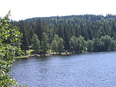
| Lake view | ||
| Geographical location | Southern Black Forest | |
| Tributaries | Kähnerbächle | |
| Drain | Windgefällbach (canal) to Schluchsee | |
| Location close to the shore | Titisee-Neustadt | |
| Data | ||
| Coordinates | 47 ° 51 '7 " N , 8 ° 7' 33" E | |
|
||
| Altitude above sea level | 966.2 m above sea level NHN | |
| surface | 19.81 ha | |
| length | 700 m | |
| width | 400 m | |
| Maximum depth | 6 m | |
|
particularities |
Reservoir, integrated into the Schluchseewerk since 1932 |
|

The Windgfallweiher is a reservoir between the Titisee and the Schluchsee in the south of Baden-Württemberg in the Black Forest . It lies in a hollow formed by Ice Age glaciers between the towns of Altglashütten , Falkau and Aha in the area of the municipality of Lenzkirch . Together with the Schluchsee and the Titisee, the Windgälleweiher is the namesake for the Dreiseenbahn , which runs along its eastern bank. The western bank is bounded by the federal highway 500 .
Location and history
The lake is located in a valley that runs from the Seebachtal in the northwest to the Schluchsee in the southeast and crosses the stream valleys that generally run northeast. This remnant of a former valley is followed by the Dreiseenbahn built between 1920 and 1926 and, since 1932, the transfer canal of the Schluchseewerk from the Seebachtal via the Haslachtal to the Schluchsee basin.
To the north of the low valley watershed between the Haslach in the north and the Ahabach in the south, which is now flooded by the Schluchsee, the glaciers of the last Ice Ages carved out a hollow in which, as the natural forerunner of today's pond, was a small moor lake. This was enlarged in 1895 by the former Falkau screw factory by a dam in the north, which raised the water level by around 6 meters. At the same time, the lake, which had previously only been fed by the Kähnerbächle flowing to the east, received a further inflow in the form of a small slope channel from the southwest. The Windgfallweiher has been integrated into the transition from the Seebach to the Schluchsee (covered slope canal) since 1932 and has been draining southwards - in the opposite direction. The water is conducted in a canal over the low watershed and then reaches Schluchsee as a windfall stream and later Schwarzach .
The lake has been under landscape protection since 1950 . In 2002, a ban on fishing and fish consumption was imposed because PCB , which dates from the 1970s, had been discovered in the sediment deposits at the bottom of the lake .
On the wooded east bank of the Windgfall Pond, which is barely touched by the streams of visitors, there is a lido whose building is a listed building.
View of the bathing area

Windgfallweiher in winter


See also
Web links
Individual evidence
- ↑ In the geomorphological literature it is called Ur-Schwarza or Ur-Mettma Valley . (Ekkehard Liehl: Landscape history of the Feldberg area . In: State Institute for Environmental Protection Baden-Württemberg (Ed.): The Feldberg in the Black Forest. Subalpine Insel im Mittelgebirge , Karlsruhe 1982, pp. 13–147)
- ↑ State Institute for the Environment Baden-Württemberg (LUBW) ( information )
- ^ Windgfallweiher at hochschwarzwald.de
- ↑ Ralf Morys: Authorities reassess the contaminated PCBs in Windgfallweiher , Badische Zeitung, May 25, 2013, accessed on November 23, 2014
- ↑ Schluchseewerk AG: Water law proceedings upper level houses , 2016, p. 51
- ↑ Tina Hättich: Feldberg: Pretzels and standing paddling at the pond. Badische Zeitung, June 8, 2013, accessed on December 23, 2016 .