
Haslach (Wutach)
| Haslach | ||
 The Haslach in the narrow valley below Lenzkirch |
||
| Data | ||
| Water code | EN : 2198 | |
| location |
Black Forest
|
|
| River system | Rhine | |
| Drain over | Wutach → Rhine → North Sea | |
| source | North-east slope of Bärhalde 47 ° 51 ′ 1 ″ N , 8 ° 4 ′ 49 ″ E |
|
| Source height | 1265 m above sea level NHN | |
| Confluence with the Gutach | at Lenzkirch -Kappel coordinates: 47 ° 51 '59 " N , 8 ° 15' 55" O 47 ° 51 '59 " N , 8 ° 15' 55" O |
|
| Mouth height | approx. 721.5 m above sea level NHN | |
| Height difference | approx. 543.5 m | |
| Bottom slope | approx. 31 ‰ | |
| length | 17.7 km | |
| Catchment area | 52.28 km² (before 1931: 53.95 km²) |
|
| Discharge at the mouth (natural discharges) A Eo : 52.28 km² |
MNQ MQ Mq MHQ HHQ |
210 l / s 1.16 m³ / s 22.2 l / (s km²) 19.32 m³ / s 79 m³ / s |
| Reservoirs flowed through | Weiher threshold in Falkau | |
| Communities | Neuglashütten, Altglashütten, Falkau, Lenzkirch | |

The Haslach is, together with the much larger Gutach , which drains the Titisee , a source river of the Wutach in the southern Black Forest . It generally flows eastwards from the Feldberg area through mostly broad-bottomed valleys until it meets the Gutach from the right , already in the Wutach gorge system .
geography
Course and valley landscape
The source area of the Haslach and its first tributaries is the eastern slope of the elongated, multi- peaked mountain ridge of the Bärhalde ( 1318.8 m above sea level ). With a steep gradient, the stream reaches a traversing valley, which still clearly shows a former river valley that drained to the southeast. In this partially boggy lowland, the Red Sea , the Haslach flows from the left to the Rotmeerbach. A concealed canal , built as part of the Schluchseewerk , also crosses under the Haslach here. Since 1931 it has been supplying water from the upper Seebachtal to the Schluchsee , plus around 180 l / s from the Haslach. It first swings a little in the direction of the valley and then leaves it again between the towns of Altglashütten and Hinterfalkau. The Schwarzenbach flows here from the right, and its name refers to the boggy valley floor. Until the construction of the discharge channel also the outflow of fed from cabbage and Kähnerbächle reached Windgfällweihers the Haslach.

From Mittelfalkau the Haslach overcomes three small valley steps down to the Stoffelsloch , the beginning of an elongated, long-silted lake basin in the Mühlinger Tal , a legacy of the last ice age glacier flow from the Feldberg area. The Haslach has cut a short gorge into the lowest of these steps, at the beginning of which it forms the Falkauer Laufen, which is 8 meters high . Here the brook crosses the southern fault line of the Lenzkircher Graben , which is also recognizable in the surrounding terrain , a section of the Bonndorfer Graben, which can be traced from the Kaiserstuhl to Lake Constance .
In front of the mountain ridge of the Hochfirst , which stretches to the southeast , the Haslachtal gives way in a gradual curve to the right and flows through the commercial town of Lenzkirch for almost 3 kilometers from Alt-Urach Castle . Below Oberlenzkirch, the actual town center, the most important tributary, the Urseebach , flows from the right . From the former glacier lake of the Urseetal , a moor with residual lake has been preserved.
From Unterlenzkirch, the valley floor gradually sinks below the surrounding level of the wide valley, creating a box valley, increasingly clear down the valley . After three kilometers it narrows to the gorge. Her two closest sites are the narrow valley at 30 meters high Höllochfelsen and especially about 20 meters deep, in porphyry cut rocks gorge of computing rock . A little below it, the Haslach and Gutach merge in a small widening of the gorge, each spanned by a footbridge, which from here bears the name Wutach .
Tributaries
(List of tributaries from the headwaters to the estuary: length of water, catchment area and altitude according to the corresponding layers on the LUBW's online map)
The source area of the Haslach (initially Haslachbach ) lies at about 1245 m above sea level. NHN on the eastern slope of the multi- peaked Bärhalde ( 1318.8 m above sea level , highest mountain east of the Feldberg ). Until the first tributary, this uppermost source stream has a length of 1.0 km and a catchment area of 0.42 km².
- Lochgrabenbach, from the left and northwest to about 1055 m above sea level. NHN in Neuglashütten :
1.0 km; approx. 0.8 km². Headwaters at about 1220 m above sea level. NHN im Loch , a cirque on the eastern slope of the Bärhalde ( 1299 m above sea level ) - Rotmeerbach, from the left and northwest to about 959 m above sea level. Above sea level in the boggy Red Sea basin :
1.7 km; approx. 1.8 km². Headwaters at about 1065 m above sea level. NHN at the Drehkopf ( 1,198 m above sea level ) south of Bärental - Schwarzenbach, from the right and southwest to about 944 m above sea level. Above sea level in the Lochert valley, northeast of Altglashütten:
2.9 km; approx. 2 km². Headwaters at about 1210 m above sea level. NHN in the southeastern foothills of the Bärhalde ( 1250 m above sea level ). At this point the stream flowing out of the Windgfallweiher also flows until the water was diverted to the Schluchsee.
In Falkau the brook is dammed in the Weiher Schwelle (approx. 0.6 ha) and one kilometer further reaches the two-tier waterfall Falkauer Laufen (from 899 m above sea level to 887 m above sea level ). There the main fault crosses the Lenzkircher trench in the south.
_-_Falkauer_Wasserfall.jpg)
- Ölesteigbächle or Elisteigbächle, from the left and north to about 845 m above sea level. NHN at the northernmost point of the Haslach run near the hamlet of Mühlingen :
1.3 km; 1.1 km². Headwaters east of the Saiger height at about 970 m above sea level. NHN . - Ölebächle, from the left and north to about 835 m above sea level. Above sea level in the east of the hamlet of Mühlingen:
1.9 km; 1.8 km². Headwaters at about 995 m above sea level. NHN south of the Hochfirst 1196.9 m above sea level. NHN . - Hierabächle, from the left and north to about 822 m above sea level. NHN on the north-western outskirts of Lenzkirch :
1.4 km; 2.2 km². Headwaters at about 960 m above sea level. NHN in the hamlet of Hiera south of the Hochfirst -
Urseebach , from the right and west to about 800 m above sea level. NHN in the center of Lenzkirch:
5.1 km; approx. 10.3 km². Headwaters at about 975 m above sea level. NHN north of the Zwerisberg ( 1129.6 m above sea level ) - Herrgottsbächle, from the right and southwest to about 790 m above sea level. NHN in the eastern area of Lenzkirch:
1.4 km; approx. 1.1 km². Headwaters at about 880 m above sea level. NHN northeast of the Pflumberg ( 1100 m above sea level ) - Geschindbach, from the right and southwest to about 782 m above sea level. NHN opposite the Lenzkirch sewage treatment plant:
3.4 km; approx. 3.8 km². Headwaters at about 1050 m above sea level. NHN southwest of the Pflumberg ( 1100 m above sea level ) - Roodbach, from the left and southwest to about 768 m above sea level. NHN south of Kappel :
3.5 km; approx. 4.0 km². Headwaters at about 960 m above sea level. NHN on the southeast slope of the Hochfirst. - Klausenbächle, from the right and southwest to about 766 m above sea level. NHN east of Lenzkirch:
4.4 km; approx. 5.2 km². Headwaters at about 1060 m above sea level. NHN east of the large forest ( 1108 m above sea level )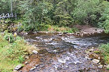 Confluence of the Haslach (front) and the Gutach to the Wutach
 - Kreuzschachenbächle, from the right and south to about 754 m above sea level. NHN in the western part of the Haslach Gorge:
1.1 km; approx. 0.2 km². Headwaters at about 880 m above sea level. NHN on the Kreuzschachen - Schleifenbächle, from the right and south to about 748 m above sea level. NHN in the middle Haslach gorge:
0.9 km; approx. 0.4 km². Headwaters at about 855 m above sea level. NHN northwest of Holzschlag ( Gündelwangen )

At the confluence of the Haslach (from the right) with the Gutach zur Wutach at approx. 721.5 m above sea level. NHN near Gündelwangen ( Bonndorf in the Black Forest ) the stream ends after 17.7 kilometers.
Transport and development
The development of traffic in the Haslachtal was and is in the main directions rather perpendicular to the valley. In Lenzkirch, after 1786, a country road crossed the brook, coming from Titisee via Seesteige , or Saiger Steig , into today's road to Bonndorf ( B 315 ). Today the B 315 reaches Lenzkirch along the northern slopes of the valley and thus follows the broad depression of the Lenzkircher trench. Today's cross-traffic runs more strongly over the valley, which crosses the Haslach near Altglashütten (capital of the Feldberg community). In addition to the B 500, it is followed by the three - track railway with the Feldberg-Bärental station , which was built until 1926, and is the highest standard-gauge station in Germany on the watershed to the Seebach valley . The lower, ravine-like Haslachtal was crossed by a branch line of the Höllentalbahn , which went to Bonndorf and was closed in 1977 , which had a hairpin at Lenzkirch station .
- Places and traffic

Altglashütten in the wide upper valley

Lenzkirch, the main town in the Haslach valley
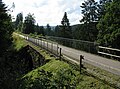
Rail bike path on the earlier route to Lenzkirch


Individual evidence
- ↑ a b c d State Institute for the Environment Baden-Württemberg (LUBW) ( notes ), height according to the contour line image on the background layer topographic map
- ↑ a b State Institute for the Environment Baden-Württemberg (LUBW) ( notes ), length according to the water network layer ( AWGN )
- ↑ a b c d Geoportal Baden-Württemberg: LUBW Service Flowing Waters - discharge parameters , accessed on May 11, 2020
- ^ Schluchseewerk AG: Water law procedure upper level houses, application part C; Explanatory report , Laufenburg 2016; accessed on May 3, 2020
- ↑ Note: The name Hangrohrkanal given in the LUBW's online map series for the waterway network is not in use for the Rotmeerbach. It can currently be assumed (May 12, 2020) that this is a transmission error, because the slope pipe canal, which carries water from the Seebach area to the Schluchsee, runs a short distance away.
literature
- Geographisch-Kartographisches Institut Meyer [Hrsg.]: Meyers Naturführer - Südschwarzwald Mannheim, 1989 ISBN 3-411-02775-4 .
- State Institute for Environmental Protection (Ed.): The Wutach - Natural history monograph of a river landscape. = Natural u. Landsch.-Schutzgeb. Baden-Württ., Vol. 6, Karlsruhe, 1988 ISBN 3-88251-135-4 .