Feldberg Glacier
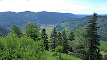
The Feldberg glacier was a large area of glaciation of the Feldberg massif and the surrounding valleys of the southern Black Forest in a radial direction during the last ice age, the Würm glaciation . It already existed on a larger scale in the Riss Ice Age . Today numerous terminal moraine walls , boulders , glacier cuts , cirques and trough valleys in the greater Feldberg area bear witness to the last glacial shape .

Extension and main streams

The total area of the Feldberg glacier in the high glacial of the Würm glacial period was approx. 900–1000 km². The flattened peaks of the Feldberg are evidence of their temporary cover with ice caps (plateau glacier). Some peaks protruded from the ice as nunatakkers ; the summit of the 1,414 meter high Belchen was also frozen in the Würm and belonged to the western edge of the Feldberg glacier. The valley glaciers extended into all the valleys leading radially away from the Feldberg with (clockwise) the Titisee glacier, Schluchsee glacier, Alb glacier, Wiesental glacier, St. Wilhelmer valley glacier and Zastlertal glacier. The longest valley glacier was the Albtal glacier. With a length of 25 kilometers to the village of Niedermühle, it reached roughly the size of the Aletsch Glacier , which is now the longest glacier in the Alps . The Albtal glacier towered over the 1,038 meter high Lehenkopf near St. Blasien and completely covered the area of today's municipality of Dachsberg . The Wiesental glacier reached as far as Mambach (Zell) when it was most icy , which corresponds to a length of 20 kilometers. The question of a connection between the Feldberg Glacier on the Upper Rhine and the Rhine Glacier flowing north and along the High Rhine to the west during the Riss Ice Age has not yet been finally clarified according to current research. The thickness of the ice in the upper valley areas in the nutrient zone of the main glacier was several hundred meters during the high glacial period. At pass heights such as the Äulemer Kreuz or on the Muchenland, the ice thickness is stated to be several tens of meters.
The glacier in the Riss and Würm glacial periods
The southern Black Forest was extensively glaciated in the last two glacial periods. In the first cold periods of the Pleistocene , the peaks of the Black Forest probably did not reach sufficient heights for persistent glaciation. During the crack glaciation, the radial arms of the Feldberg Glacier reached a length of up to 35 kilometers. The snow line was 700–800 meters (today the north side of the Alps: 2,500–2,800 meters), the deepest terminal moraines were at 500 meters. The principles and landscape formations of the Riss Ice Age were the same as in the later Würm Ice Age. However, many of the earlier manifestations were overprinted by the last glacial period and have now disappeared. The most recent Würm glaciation therefore provides the best evidence of the Feldberg Glacier. The high glacial phase of the Würm glacial period, which began 115,000 years ago, reached a geological history only briefly lasting, beginning with a temperature drop 28,000 years ago and a maximum of glaciation 20,000 years ago and an average temperature of −4 ° C. The climate was much drier than it is today, and most of the precipitation fell as snow. In the Black Forest, continuous permafrost can be assumed during the high glacial period. This was crucial for the effectiveness of the ice removal processes. Glaciation had already peaked 18,000 years ago. The melting process began in the subsequent late glacial period. The Feldberg valleys were free of ice again 12,000 years ago at the latest, with the retreat of the Feldberg glacier and other glaciers in several stages with intermediate stoppages and smaller new advances.
Meltdown stages
After the highest level of glaciation around 20,000 years ago with a snow line of 1000 meters, the Feldberg Glacier retreated in proven stages. The first stage of retreat was the Titiseestand 15,000 years ago and the Bärentalstand 14,000 years ago. 12,000 years ago, the last stage was the Feldseestand with a snow line of 1,300 meters.
Deflection of the Feldberg-Danube
During the glaciation of the Feldberg, the Wutach am Feldberg was the original source of the Danube. The Feldberg-Danube still drained in the Würm high glacial as the original Danube in a wide valley in the direction of today's Danube. Shortly after the maximum glaciation between 17,000 and 18,000 years ago, the Wutach was able to tap into the Danube through retrograde erosion and divert it into the Upper Rhine. The Danube lost its original headwaters on the Feldberg. This changed the watershed between the Danube and the Rhine.
Today's witnesses to the glacier

In the greater Feldberg area, numerous evidence of the former glaciation can be found today. Some examples are:
- Delta remnants of an ice rim reservoir: Langenordnachtal gravel pit ( Titisee-Neustadt )
- Terminal moraine: Menzenschwander Albtal Height: 15 meters (Klusen moraine of the Feldsee stand), Jostal (maximum stand of the Titiseegletscher)
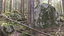
- Boulders ( Erratic blocks ): Schwarzatal below Schluchsee dam; largest boulder in Michelrütte near Schönau (Wiesental) with 180 tons
- Gletscherkessel: Gletscherkessel Präg (confluence of six glacier arms with a valley hollow); also in Menzenschwand the confluence of the Alb valley and the Krunkelbach glacier.
- Glacier cut : at the Zastler Hütte , scarred erratic blocks in Hinterzarten, 10 * 3 meter large scarred rock slab on the Letzberg near Schönau (Wiesental)
- Glacier pots in the Albtal Gorge ( Teufelsküche ) and in Schwarzenbächle below Lindau ( Todtmoos ) ( Krai-Woog-Gumpen )
- Raised moors (late Ice Age relics as a result of glacier retreat ): Horbacher Moor ( Dachsberg ), Hinterzartener Moor, Tiefenhäusener Moor ( Höchenschwand )
- Kamesterrasse : glazed terrace in the Präg glacier basin
- Kare: Herzogenhorn - Wechte , Feldbergwechte to Feldsee, Zastler Loch , Katzensteig-Kar ( Todtnau )
- Karseen: Feldsee with east-facing terminal moraines, Nonnenmattweiher (Belchen), Klosterweiher (Dachsberg) . The Kargrund on the Herzogenhorn has not been excavated into a tub like on the Feldsee, and the Karriegel is also missing. Therefore no lake could form. In this case one speaks of a carembryo .
- Moutonnée : Präg, Menzenschwand, Hanselmichelehof ( Hinterzarten ) Katzensteig Card ( Todtnau )
- Lateral moraine : Menzenschwand north side
- Transfluence : Highest ice transfluence in the Black Forest on the summit plateau of the Bärhalde near Altglashütten with gneiss debris from the Herzogenhorn; Ice transfluence from the Albtal glacier to the Schluchsee glacier at the Äulemer Kreuz and in houses from the Albtal to the Schwarzatal
- Toteisloch : in Titisee (place)
- Trough valleys : Menzenschwander Tal (Albtal), Bärental, St. Wilhelmer Tal , Zastlertal
- Zungenbeckensee : Titisee , Schluchsee (before the damming)
literature
- Bernhard Metz, Helmut Saurer: Geomorphology and landscape development. In: Regional Council Freiburg (Hrsg.): The Feldberg - Subalpine island in the Black Forest. Jan Thorbecke Verlag, Ostfildern 2012, ISBN 978-3-7995-0757-8 , pp. 27-62.
- Ekkehard Liehl : Landscape history of the Feldberg area - II. The ice age and its forms. In: Arno Bogenrieder u. a .: The Feldberg in the Black Forest. Subalpine island in the low mountain range. State Institute for Environmental Protection Baden-Württemberg, Institute for Ecology and Nature Conservation, Karlsruhe 1982. (= The nature and landscape protection areas of Baden-Württemberg, Volume 12). ISBN 3-88251-046-3 , pp. 30-99.
- Christoph Hebestreit: Wutach and Feldberg region - a geological guide. Spektrum Akademischer Verlag, Heidelberg, Berlin 2002, ISBN 3-8274-1241-2 .
- K. Rother: The Cold Ice Age glaciation of the German low mountain range as reflected in recent research. In: Petermanns Geographische Mitteilungen 139, 1995, ISSN 0031-6229 , pp. 45-52.
- Adolf Zienert: Würm retreat stages from the Black Forest to the High Tatras . In: Ice Age and the Present. Volume 21, 1970, pp. 58-70, doi: 10.3285 / eg . 21.1.05 .
Web links
- Glaciation of the Black Forest and the Alpine Foreland in the Pleistocene (image file)
- Glacial morphology of the southern Black Forest in the area of the Feldberg-Schauinsland-Horstes (school excursion guide)
Individual evidence
- ↑ The glaciation of Beichengebietes (Südschwarzwald) for Würm ( Memento of the original July 21, 2016 Internet Archive ) Info: The archive link is automatically inserted and not yet tested. Please check the original and archive link according to the instructions and then remove this notice. Ice Age and Present. 37. p. 31.39. 1987
- ↑ a b c Joachim Eberle, Bernhard Eitel, Wolf Dieter Blümel, Peter Wittmann: Germany's South from the Middle Ages to the present. 2nd edition, Spektrum Akademischer Verlag, Heidelberg 2010. ISBN 978-3-8274-2594-2 .
- ↑ a b c d e f Traces of the Ice Age in the Southern Black Forest Nature Park. Regional history series of the Southern Black Forest Nature Park, Vol. 1. ISBN 3-9810632-0-1 .
- ↑ Information board at the Krai-Woog-Gumpen
- ↑ a b c d e f g Geotopes in the administrative region of Freiburg State Institute for Environmental Protection Baden-Württemberg
- ↑ Note: Glacier pots are referred to as glacier mills in the Black Forest . However, these are formed from ice in the ice itself.
- ^ Badische-Seiten.de: Krai-Woog-Gumpen
- ↑ Horbacher Moor ( Memento of the original from July 14, 2016 in the Internet Archive ) Info: The archive link was inserted automatically and has not yet been checked. Please check the original and archive link according to the instructions and then remove this notice.
- ↑ Hinterzartener Moor nature reserve
- ^ Tiefenhäusener Moor
- ↑ Nature Conservation Center Southern Black Forest. Achim Laber, Stefan Büchner (2007) in the Museum House of Nature on the Feldberg
- ^ Basement Black Forest Ministry for the Environment, Climate and Energy Baden-Württemberg


