Klosterweiher (Dachsberg)
|
Horbacher See monastery pond |
||
|---|---|---|

|
||
| Monastery pond, Horbach | ||
| Geographical location | Waldshut district , Baden-Württemberg , Germany | |
| Drain | Otlisbächle → Mühlebächle → Höllenbächle → Alb | |
| Data | ||
| Coordinates | 47 ° 44 ′ 7 " N , 8 ° 6 ′ 17" E | |
|
|
||
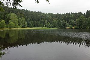
The monastery pond , also called Horbacher See , is a small lake in the southern Black Forest between St. Blasien and Dachsberg near Horbach in the Waldshut district . It lies in a coffin and was dammed up as a fish pond for the St. Blasien monastery for the fasting fish it needed . This use has been documented since the 18th century. The pond, which had since fallen into disrepair and was muddy, was dammed again in 1952 by an embankment. A small silted up part of the lake is part of the Friedrich-August-Grube nature reserve . The monastery pond is a late Ice Age relic as a result of the retreat of the Feldberg glacier from the Dachsberg.
A few hundred meters to the north is the Horbacher Moor nature reserve .
literature
- Bernhard Stein: Parke and Wandere , Volume 9, 1979 ISBN 3-87804-073-3
- Christian Neumann: The lakes of the Black Forest , 1978, ISBN 3-921340-34-9
- Rudolf Metz : Geological regional studies of the Hotzenwald , 1987 ISBN 3-7946-01742
Web links
Commons : Klosterweiher - Collection of images, videos and audio files
Individual evidence
- ↑ Acknowledgment of the Friedrich-August-Grube nature reserve , accessed on May 18, 2014
