
Zell im Wiesental
| coat of arms | Germany map | |
|---|---|---|

|
Coordinates: 47 ° 42 ' N , 7 ° 51' E |
|
| Basic data | ||
| State : | Baden-Württemberg | |
| Administrative region : | Freiburg | |
| County : | Loerrach | |
| Height : | 443 m above sea level NHN | |
| Area : | 36.13 km 2 | |
| Residents: | 6325 (December 31, 2018) | |
| Population density : | 175 inhabitants per km 2 | |
| Postal code : | 79669 | |
| Area code : | 07625 | |
| License plate : | LÖ | |
| Community key : | 08 3 36 103 | |
| LOCODE : | DE ZEW | |
City administration address : |
Constanze-Weber-Gasse 4 79669 Zell im Wiesental |
|
| Website : | ||
| Mayor : | Peter Palme | |
| Location of the city of Zell im Wiesental in the Lörrach district | ||
  |
||


Zell im Wiesental is a town in the district of Lörrach in Baden-Württemberg ( Germany ). It was probably founded at the beginning of the 11th century in the Upper Wiesental as a monk's cell / hermitage of the Säckinger Fridolinskloster and first mentioned in 1275. Zell was the center of a stiftsacking Dinghof , for which the gentlemen of Schönau held the office from the 14th century . The main town and the surrounding villages belonged to Upper Austria and later to the Grand Duchy of Baden , from whose Grand Duke Karl Friedrich Zell received town charter in 1810 . As in the rest of the Wiesental, industrialization began quite early in Zell, and in the 19th and 20th centuries the city was an important production location for the Baden textile industry .
geography

Geographical location
Zell im Wiesental forms the center of the Zeller Bergland, which extends in the southernmost part of the Black Forest at an altitude of 415 to 1300 m above sea level between Basel and the Feldberg in the great Wiesental. The dominant mountains are the Zeller Blauen ( 1077 m ) north of Zell and the Hohe Möhr ( 989 m ) in the south-east, on the Schopfheimer district . The highest point in the Zeller district is also on the Blauen; it is deepest in the southwest on the border with Hausen at 415 m . In addition to the city itself, its localities Adelsberg , Atzenbach , Gresgen , Mambach , Pfaffenberg and Riedichen as well as the municipality of Häg-Ehrsberg belong to this region. The districts of Zell, Atzenbach and Mambach are located in the valley of the meadow, while Adelsberg, Gresgen, Pfaffenberg and Riedichen are significantly higher at 660 m , 708 m , 730 m and 650 m - 710 m .
Neighboring communities of Zell are, clockwise (starting from the north): Kleines Wiesental , Fröhnd , Häg-Ehrsberg , Schopfheim and Hausen im Wiesental . Due to a forest enclave northwest of the actual district between the Häg-Ehrsberg districts of Happach and Altenstein, Zell also borders Todtmoos and thus the district of Waldshut .
City structure

The town of Zell im Wiesental and 20 other villages , hamlets , Zinken and farms or houses belong to the town of Zell im Wiesental with the formerly independent communities of Adelsberg, Atzenbach , Gresgen , Mambach , Pfaffenberg and Riedichen .
The villages of Adelsberg (with upper and lower village) and Blauen belong to the former municipality of Adelsberg. The former communities of Atzenbach and Gresgen only consist of the villages of the same name. The former municipality of Mambach includes the village of Mambach, the Zinken Saufert and Silbersau, the Mühlschau farm, the cotton spinning mill and the Maria Frieden mountain hermitage. The village of Pfaffenberg, the hamlet of Käsern and the Zinken Helblingsmatt and Hollbühl (Biegematthof) belong to the former municipality of Pfaffenberg. The village of Riedichen, the hamlet of Gaisbühl and the Zinken Grüneck and Hütten belong to the former municipality of Riedichen. The town of Zell im Wiesental within the borders of February 29, 1972 includes the town of Zell im Wiesental and the farms of Oberer Henschenberg and Unterer Henschenberg.
In the area of the former municipality of Atzenbach are the desert areas of Itzingen, Schowingen and Zizingen.
In the course of the secularization of the St. Blasien monastery , Zell im Wiesental and some suburbs were given forest areas northwest of the actual district, which led to the exclaves still existing today, surrounded by Häg-Ehrsberg and Todtmoos. Of the areas, 156 hectares are between Happach, the hamlet of Forsthof and the Hohe-Muttlen on Zell. Adelsberg has 43 hectares on the Sägenhalde near Schürberg-Säge, Atzenbach 25 hectares near Kupferbühl west of Forsthof and the St. Antoni Pass, and Riedichen has 24 hectares near Dietenschwander Kopf .
The formerly independent municipalities that were incorporated in the 1970s form localities within the meaning of the Baden-Württemberg municipal code with their own local councils and local councilors as their chairmen.
geology
The Zeller Bergland forms a southern extension of the Black Forest , in which two types of rock predominate: In the southwest, on the border with Hausen, you can find “ Malsburger Granite ”, to the northeast, around Hohe Möhr and Zeller Blauen, dominated by “Mambacher Syntexit”. The latter is igneous rock that was created by mixing magma with metamorphic sediments . In both rock regions there are also numerous granite and porphyry dykes running in a northwest-southeast direction . In the crack-cold period cell was completely covered by ice, in the Wiirm cold period Meadow glacier reached until Atzenbach; any moraines , however, were probably washed away by the meltwater and erosion.
climate
Due to the large differences in altitude in the Zeller district, there are also significant climatic differences between the various districts, whereby the higher-lying districts usually have lower temperatures and higher amounts of precipitation, which are also manifested in the fact that the apple blossom there about 10 days later than in the valley . There is a weather station in the Eichen district of Schopfheim at a similar altitude to the city of Zell. The temperature and precipitation values measured there are shown in the following table:
|
Monthly average temperatures and precipitation for Schopfheim oaks
Source:
|
||||||||||||||||||||||||||||||||||||||||||||||||||||||||||||
Since 1987 there has also been a station in the Pfaffenberg district of Zell at 730 m . In 1988 this station registered a precipitation level that was around 550 mm higher than oak.
Natural landscape
The entire municipality of Zells is part of the Southern Black Forest Nature Park and the Black Forest biosphere area . Zell also has a share in two Fauna-Flora-Habitat (FFH) areas: 111.87 hectares of the district belong to the FFH area "Weidfelder im Oberen Wiesental". The cultural landscape of pasture fields, beech forests and meadow streams typical of the Black Forest has a total area of more than 1700 hectares and offers, among other things, a habitat for bullhead , brook lamprey , green fork-tooth moss , Spanish flag and large mouse-eared mouse . 3.53 hectares of the district also belong to the FFH area "Röttler Wald". It is a more than 2500 hectare large, structurally rich forest and meadow area with old beech stands distributed over several communities . The species native to it include the yellow-bellied toad , the stag beetle , the helmet-azure damsel , the green fork-toothed moss , the Bechstein's bat and the ciliated bat and the great mouse-eared bat . A small district piece of 1.71 hectares is also part of the SPA "Southern Black Forest" (total 33,515.91 hectares), whose species inventory including the eagle owl , peregrine falcon , black kite , honey buzzard and the Zitronengirlitz belong.
There are also seven natural monuments in the Zell area. These are the top of the "Rümmelesbühl" near Gresgen, the Atzenbach waterfalls, the Höll waterfalls near Pfaffenberg, the Fischbach waterfalls near Zell and three trees: a single willow linden tree in the "Moosrain" near Pfaffenberg, the spruce "Lonely Fir ”near the Hohe Möhr and a willow beech in the“ Erlenboden ”near Gresgen.
history
First settlement and mention
Zell was probably founded around the year 1000 as a monk's colony or hermitage (cella) of the Säckingen Fridolin Monastery in Säckingen. Zell was first mentioned in a document in 1275 in the tithe book of the Diocese of Constance . In it, Pastor Waltherus in Celle asked for two installments of 34 and 33 pounds in Basel currency as a crusade tithing. Atzenbach and Gresgen were mentioned in documents of today's districts before Zell. Both appear as Atzo and Greszkon in a deed of donation from Walcho von Waldeck from 1113. The place name Gresgen is probably based on Grasinchoven , a name that suggests an origin in the 9th or 10th century. The other districts were all mentioned later: Mambach in 1377, Pfaffenberg and Riedichen (together with Gaisbühl, but without Käsern, which was mentioned in 1396) in the Säckinger Zinsrodel of 1439. The same applies to Adelsberg, in which, however, probably one residential tower from the 13th century.
Dinghof and Bailiwick of Säckingen Abbey
The ownership structure in today's Zeller district was shaped by numerous lords, claims and rights (see also the article on the history of the Wiesental ). The monasteries of St. Blasien and Säckingen as well as the lords of Stein and the Röttel side line of those of Rotenberg, who were especially wealthy in Gresgen, should be mentioned here. After several donations, however, there was a certain consolidation, with the entire current municipality area, with the exception of Gresgen , coming to the Säckingen monastery and thus to the Habsburgs ( Upper Austria ), Gresgen under margravial Baden sovereignty. Zell formed the main place of a Dinghof or a bailiwick . With the exception of Gresgen, this comprised the entire area of today's political communities of Zell and Häg-Ehrsberg, an area of around 5200 hectares. In the 14th century, the management of the courtyard was passed from the von Stein / Altenstein family to the Schönau family, who were related to them and who were able to establish a manorial rule over the bailiwick that lasted until 1831. The location of Altenstein Castle is controversial; the castle belonging to the Herren vom Stein is believed to be either in the district of the same name in the municipality of Häg-Ehrsberg or on the " Henschenberg " near Zell.
Manorial rule of the Lords of Schönau

The administration of the bailiwick was incumbent on the one hand to the bailiff elected by the citizens for two years and on the other to the bailiff appointed by the manorial house. The best known bailiff was certainly Franz Fridolin Weber , the uncle of Carl Maria von Weber and Mozart's father-in-law , who held the office from 1754 to 1763. Between the various instances - Säckingen Abbey, the noble Schönau family and the bailiwick - there were disputes and lawsuits, especially from the 16th century, when the Schönauers gained more and more powers and insisted on a manorial rule instead of a penitentiary fief. Although the aristocratic manor had to suffer some setbacks, from 1601 the Säcking fiefdom for the lords of Schönau no longer spoke of the Meieramt, but of the high and low jurisdiction over the villages of the Vogtei Zell. In addition to these disputes, the population was plagued by wars and the associated labor and taxes. In the course of the war between Austria and the Swiss Confederation (see also Battle of St. Jakob an der Birs ), plundering Armagnaks moved through the area at the end of the 15th century , with a battle between two Armagnak groups supposedly north of Zell near Schönenbuchen . In 1446 there was also a campaign by the Basler against the Habsburg possessions in front of Austria, during which Zell was also plundered on Easter Monday. To protect against wandering looters, the population built so-called Landhage (Alemannic Hag for a fence) in many places . The subdivision of the Vogtei Zell into Vorderhag (today's municipality of Zell without Gresgen) and Hinterhag (today's municipality of Häg-Ehrsberg) could also be derived from such a Hague . An alternative interpretation sees the eponymous Hag as a protective wall against the spread of an epidemic. Further adversity followed during the Thirty Years' War . Because of the denominational border running through the Wiesental between the Catholic Front Austria and the Protestant Baden-Durlach , several acts of war occurred in the Baden Oberland, especially in the second half of the war. Swedish and imperial troops fought each other and occupied areas, plundered and pillaged in frequent turns. Zell was occupied by Swedish troops, and the tower of the parish church was set on fire. Further burdens of war and damage incurred during the wars of Louis XIV. , With cell but apparently got away quite happy in comparison to other towns such as Schonau or Schopfheim and "only" under occupation costs and compulsory labor for the construction of Margrave Ludwig Wilhelm von Baden-Baden conceived Defense system in the Black Forest suffered. It was similar for the Zellern in the War of the Spanish Succession . In the Polish and Austrian War of Succession, on the other hand, the city was occupied several times by the French in addition to billeting and compulsory labor and was given high contributions. In 1735 the French took the bailiff, the bailiff and eight other citizens and jury hostage to Hüningen . Zell was also occupied in 1796 in the course of the First Coalition War . On October 22nd there was a battle on the Schwarznau between the French on one side and 400 imperial soldiers and the Wiesental militia on the other. The French were forced to withdraw from the Wiesental, but six citizens of the Zeller Vogtei had died and eight others had been wounded. Another battle broke out in 1799 when an attack by the French was repulsed by an Austrian sniper company.
Early industrialization
The names of Bailiff Meinrad Montfort and his brother Peter are inseparable from the industrialization in Zell. In 1776 the bailiff applied for a permit to build a hammer forge. The Upper Austrian government approved and supported the project against resistance from the community and the population, who feared a greater risk of fire. As a result, the forge under construction was damaged, which resulted in a military division being ordered to Zell and several citizens being sent to prison . After further administrative back and forth, the Montfort brothers finally acquired a site on the Schwarznau in the south of the city and set up their hammer forge there. In addition to the hammer forge, Montfort was also active in the field of textile production in publishing: he had cotton spun in Zell and had weavers come from Augsburg to train the locals in this activity. He and his brother also ran a mill, a brewery and a bleaching plant. In the course of the French Revolution and the continental blockade later imposed by Napoleon Bonaparte , Montfort's undertakings got into trouble; the cotton factory died, only a small cotton weaving mill survived until it was sold in 1837. The hammer forge was sold to Jakob Bernauer from Hausen in 1856 and converted into a foundry.
Baden city

As a result of the Peace of Pressburg , Upper Austria and with it the Vogtei of Zell fell to Baden, which in 1806 became the Grand Duchy. The new Grand Duchy also owned the St. Blasien Abbey, which also included the forest between Todtmoos and the Hinterhag; This “superior forest” was given to Zell and the surrounding villages by the new Grand Duke. This donation formed the basis for the later forest enclave of the municipality of Zell between Häg-Ehrsberg and Todtmoos.
In 1810 Zell also received by Grand Duke Karl Friedrich , the city charter granted. In addition, the former Vogtei Zell was dissolved. The Hinterhag had its own parish Häg since 1779, but subsequent requests for political independence were rejected. On June 1, 1811, however, it was decided to divide the Vogtei Hinterhag into the new communities Häg and Ehrsberg and separate it from Zell. In the same year, the communities Adelsberg, Atzenbach, Mambach, Pfaffenberg and Riedichen were founded and also separated from Zell, whereby the city of Zell was limited to the actual core city. The superordinate administrative authority for the new municipalities became the office Schönau, for the already existing municipality Gresgen the office Schopfheim became responsible in 1809.
On July 23, 1818, the city was almost completely destroyed by a major fire. 64 houses burned down within half an hour, 72 were destroyed in total, and two women died as a result of the fire. The reconstruction took place according to fundamentally new plans and gave the city its current core.

The 48 revolutions and the strengthening of the textile industry
At the end of the 18th century, the Montfort companies had no long-term success, but they laid the foundation for the final industrialization of the city, which began in the first half of the 19th century when Swiss manufacturers increasingly invested in the Wiesental. In 1819 Peter Köchlin set up a hand weaving mill with 250 looms, which was converted into a spinning mill in 1840. In 1837, Köchlin also took over an insolvent mill and set up a mechanical cotton sizing plant on the site, a supplier for his hand-weaving mill. Köchlin's son Johann Albert built a weaving mill in 1853 in which the looms were powered by water. In the same year, a Bölger and Ringwald foil spinning mill was set up on the site of the former Montfort cotton weaving mill. Four years earlier, in 1849, a spinning mill had also been founded in Atzenbach. The Baden Revolution of 1848/49 also fell during the period of increasing industrialization . In Zell there was a democratic people's association under the direction of several landlords (including Peter Montfort) and the mayor Alois Thoma. So it is not surprising that 80 people from Zell joined the Hecker train when it pulled around 1000 strong through the city on April 18, 1848. Two days later Franz Sigel's revolutionaries marched through Zell towards Schopfheim, but came back the next day after learning of Hecker's defeat in the battle on the Scheideck . As a third group, Georg Herwegh's “German Legion” moved into the city on April 26th to take a break. However, since government troops were already in Schönau and Schopfheim, the legionaries left after rest and discussion and were ultimately defeated at Niederdossenbach . Even Gustav Struve moved by cell. After the May Revolution was suppressed in 1849, parts of a Prussian infantry regiment were stationed in the city. Compared to nearby communities, Zell had to bear quite high war costs of almost 2500 guilders.
Zell becomes an industrial city
After the end of the Baden Revolution there was a certain stability, briefly interrupted by the wars of unification , in which several Zellers had to serve. One death occurred during the Franco-German War . The industry in Zell continued to grow during this time, and there was both a shift in the population as more and more people moved from the mountain villages of Adelsberg, Pfaffenberg and Riedichen to Atzenbach and Zell, as well as a general population growth. The population of today's urban area grew between 1852 and 1910 by 58.6% to 6046 inhabitants. The population of the core city of Zell grew by 158.7% over the same period, which shows the uneven growth and the attraction of the factories located in the valley.

On June 5, 1876, Zell was also connected to the Wiesental Railway ; Around 13 years later, on July 7, 1889, the Zell im Wiesental – Todtnau railway line , popularly known as Todtnauerli , was opened.
At the same time, there were important and formative changes in ownership for the Zell textile industry. In 1883 Gottfried Feßmann and Theodor Hecker from Kirchheim-Teck acquired the Köchlinsche Spinnerei, which grew rapidly under the name “Feßmann and Hecker” and became one of the most important companies in Zell. Another important company came into being in 1880, when the Freiburg banker Christian Mez acquired the weaving mill formerly operated by Albert Köchlin and expanded it as the “Mechanische Weberei Zell” and finally converted it into a stock corporation . In 1889 the "Webi" operated 550 looms, and in the period after that the company continued to grow with the establishment of a factory in Hottingen and the purchase of the weaving mill in the Rohmatt district of Häger. The Bögler und Ringwald foil spinning mill had also changed hands several times; from 1893 it traded as Zimerlin-Forcart & Cie. The Atzenbach spinning mill took over a worsted yarn spinning mill in Mambach in 1894 and merged with the spinning mill in Schopfheim in 1910. The increasing growth of the textile industry and its need for machines also caused mechanical engineering companies to emerge. In 1885 Karl Wittig founded a machine factory in the city center, and in 1898 Josef Krückels purchased the site of a company in financial difficulties on the outer Schwarznau in the south of the district and built a factory specializing in the manufacture of textile machines. The main product was a sizing machine designed by Krückels .

In addition to the companies already mentioned, other companies were set up in Zell in the second half of the 19th century, for example factories for the production of cellulose, leather and paper tubes. The growth of the Zell industry was not without setbacks; Fires broke out several times (1903 in the Feßmann & Hecker spinning mill, 1909 in the weaving mill), and in 1902 an engineering factory that had existed since 1850 went bankrupt. Another turning point came with the First World War ; Numerous factories had to switch to war production, so that grenades were turned in Zell and wooden shoe floors and nitrided cellulose were manufactured. The powerful Feßmann & Hecker spinning mill was one of the few factories in Baden that was allowed to continue yarn production. The city of Zell was spared any direct impact of the war (apart from the occasional dropping of French leaflets). However, military hospitals were set up in the city hospital and in the building of the trade school, and 657 young men from the city of Zell alone had to serve in the army, 124 of whom died. In relation to today's municipal area, the losses amounted to 204 dead and 9 missing.
The Wiesentäler textile riots
After the World War, the Zell textile industry returned to its old production; In 1920 the weaving mill in Zell employed 570 people, the Feßmann und Hecker spinning mill had 330 workers a year later. In the same year, the mechanical weaving mill in Zell merged with the spinning mill and weaving mill Schönau to form “Spinnerei und Weberei Zell-Schönau AG”, which now had over 1200 employees. Another 412 people were employed in the Zimerlin-Forcart & Cie spinning mill, which now spins using the Schappe method. The hyperinflation following the First World War hit Zell with full force from the summer of 1923; the banks could no longer get enough cash, which is why the workers often received their wages only with delays and the associated loss of purchasing power. Dissatisfaction grew among the workers, and the communists were particularly popular in Zell. On September 14, 1923, a general strike began in Lörrach , whereupon the city was occupied by 300 police officers. Three days later, on September 17th, a strike also began in Zell. On the same day, however, an agreement was reached with the employers who promised the workers economic aid of 50 Swiss francs . The next day there was another protest directed at the state government, but in Zell, unlike in Schopfheim, it was peaceful. On the same day, the districts of Schopfheim, Lörrach, Schönau and Säckingen were declared a state of emergency. Nevertheless, Zell did not come to rest; in November a plan of overthrow was uncovered, which had the goal of building a communist "South German Republic"; a police force ordered from Waldshut found stocks of ammunition and explosives. 32 penitentiary sentences were imposed, 17 of them against citizens of Zell. In 1925 the cellulose factory in Zell, which had 150 employees to date, ceased production, ten years later the Wittig mechanical engineering factory moved to Schopfheim.
National Socialism and World War II
Immediately after the “ seizure of power ” by the National Socialists, there were arrests of communists. Associations and parties were soon dissolved or brought into line. Due to the municipal code passed in 1935, Zell lost its town charter and became a "medium-sized municipality". Several streets in Zell were renamed in honor of prominent National Socialists such as Adolf Hitler and Robert Wagner .
A camp for the female Reich Labor Service was set up in Zell and, as the “spa town of 100 walks”, the city became a destination for KdF trips. As a Catholic city, Zell and the surrounding communities were not strongholds of the NSDAP even during the Weimar Republic (see section Politics). This was also confirmed in 1938 when, in the course of the “ Anschluss ” of Austria, 118 out of 2500 Zeller voters voted “No”. As a result, the houses of presumed no-voters were smeared with the lettering “118er”, the clerical councilor Augustin Scher was also called “118er” and on top of that as a “traitor”. A former Jewish teacher was arrested in 1938, but later apparently managed to flee to France and returned to Zell after the end of the Second World War . In the course of the Wagner-Bürckel campaign in 1940, a Jewish person was deported to Gurs .
In the Second World War, the Zell industry had to change its production again; Air bombs were now being processed, cartridges and detonators for grenades made; In the Vistra and Schappe (formerly Zimmerlin-Forcart & Cie) spinning mills, control cabinets for V2 rockets were also manufactured. In 1944, Zell was attacked by fighter bombers, resulting in one death. A year later a line of defense against the advancing French was built on the Grendel in the direction of Hausen and the meadow bridge was prepared for demolition; however, their destruction was prevented by a pioneer sergeant named Willi Gräßlin. There was no battle for Zell; When the French marched in on April 25, not from Hausen as expected, but from Gresgen, the city was flagged with white. In relation to today's community, Zell lost 429 people in World War II, 117 of them missing.
Decline of the textile industry

The Zeller textile industry had initially survived the renewed war production and the French dismantling. Zell-Schönau AG invested in new machines and established a successful brand in post-war Germany with its " Irisette " bed linen. However, the crisis began as early as the 1960s. The Feßmann und Hecker spinning mill founded subsidiaries under the names "Zellaerosol" and "Zellplastik", which concentrated on filling spray cans and gradually relocated their business to this branch. The spinning mill, which employs around 400 people, was closed at the end of the 1960s, and a small textile production facility was maintained until 1985. Schappe GmbH, renamed again in 1962, and Zell-Schönau AG continued to produce for the time being; Zell-Schönau AG took over the Atzenbach spinning mill in 1965. In 1970 there were still 1,515 textile jobs in Zell, a number which, however, continued to decline in the following period due to rationalization measures. The Todtnauerli was not spared from problems either; In September 1966, passenger traffic was discontinued on the Oberer Wiesentalbahn, and freight traffic a year later. The tracks have been completely dismantled, and the former route has now been converted into a railway cycle path .
From the end of the 1960s, the two remaining textile companies also changed hands several times, with Schappe GmbH moving to the American manufacturer Burlington , Zell-Schönau AG initially to the Backnang company Adolff, and later to the Drews company in Schrozberg . As early as the 1970s, the Zell industry was in crisis again: Schappe GmbH closed its doors in 1974, and Zell-Schönau AG closed production sites in Alsace and Rohmatt in 1977. Through these and other measures, the company halved its workforce from 4,000 to 2,000 employees in the six years between 1972 and 1978, but could not stop the decline: in 1987 there were only 574 textile jobs in Zell, and four years later all of the Zell Companies belonging to Schönau are closed.
Incorporations
In the years 1972 to 1975 were under the administrative reform in Baden-Wuerttemberg communities Adelberg Atzenbach (1 January 1975), Gresgen (October 1, 1974) (1 January 1974), Mambach (1 January 1975) Pfaffenberg (January 1, 1975) and Riedichen (March 1, 1972) incorporated. The former Vorderhag of the Vogtei Zell was reunited and expanded to include the former Baden community of Gresgen. With the Hinterhag , which was also reunited as the municipality of Häg-Ehrsberg, an agreed administrative community was also established.
- Coats of arms of the former municipalities

Adelsberg

Atzenbach

Gresgen

Mambach

Pfaffenberg

Riedichen


population
On December 31, 2009, Zell had 5987 inhabitants, around 15 percent of whom were foreigners. The average age is 42.9 years (women) and 40.3 years (men); the average household size in 2006 was 2.4 people, slightly above the national average of 2.2. In December 2016 the population in Zell was 6,226.
religion
The present city area was divided from the Reformation period: the Upper Austrian districts of Zell, Atzenbach, Mambach, Adelsberg, Riedichen and Pfaffenberg remained Catholic, while Gresgen in Baden became Protestant. In the second half of the 19th century, increasing industrialization led to the influx of Protestants to the valley towns of Mambach, Atzenbach and Zell, where in 1895 they made up around 27.3% of the population. The mountain towns of Gresgen, Adelsberg, Riedichen and Pfaffenberg, on the other hand, retained their denominational homogeneity. It is also noteworthy that a relatively strong Old Catholic community was formed in Zell at the beginning of the 20th century. The relationship between Catholics and Protestants has remained relatively constant in the entire community since then; In 1987, 26.8% of the population declared Protestantism, 61.7% Catholicism.
For many centuries the entire Vogtei of Zell also formed a parish; In 1779, however, the Hinterhages was detached, for which a separate Häg parish was created. Another detachment took place in February 1942 when the Atzenbach Curate was created, which later became the Atzenbach parish and looked after the then independent communities of Atzenbach, Mambach, Riedichen and Pfaffenberg. The three Catholic parishes of St. Michael in Häg, Assumption of Mary in Atzenbach and St. Fridolin in Zell still exist today, but together form the pastoral care unit Zell im Wiesental of the Wiesental dean's office in the Archdiocese of Freiburg .
The evangelical community in Zell was initially looked after from Hausen. Efforts began in 1879 to establish a community of their own, and at Christmas of the same year the first Protestant service in Zell was held in the Löwen's inn . In 1886 a pastoral clergyman was appointed to Zell for the first time, and in 1892 the Protestant parish was finally established in Zell. Gresgen, in which its own church is documented as early as 1267, plays a special role. Gresgen initially apparently also belonged to the Zeller parish, but with the introduction of the Reformation in Baden-Durlach in 1556, the place was assigned to the parish of Tegernau. The population initially resisted the ordered change of faith, but margravial threats of punishment ultimately enforced the Reformation, and Gresgen came to the Protestant parish of Tegernau, to which it still belongs today. Both the parish of Zell and the parish of Tegernau and thus the entire city of Zell belong today to the Schopfheim region in the Markgräflerland Evangelical Church district of the Evangelical Church in Baden .
In 1874 an old Catholic association was founded in Zell, from which a parish developed in the following period; The Christ Church belonging to the parish was started in 1891 and completed in 1892. At times the old Catholic community in Zell was responsible for the pastoral care of 381 old Catholics in the entire district of Lörrach; the number of members decreased steadily in the course of the 20th century, so that the parish of Zell was dissolved in 1978; the parish of Säckingen has been responsible for the old Catholics of Zell since then. Since 1950 there has also been a New Apostolic Church congregation in Zell .
dialect
Like the rest of the Wiesental, Zell im Wiesental belongs to the High Alemannic language area . The initial sound shift from k to ch is characteristic of the dialect: Chind, Chopf, Chuchichäschtli . The Wiesentäler Alemannic is not homogeneous, however, but differs from place to place. The poems of the Zeller Leveraging Prize winner Gerhard Jung can be seen as an example of the local dialect .
politics
Municipal council
The last election to the local council took place on May 26, 2019. With a turnout of 56.6% (+ 5.9 * ) it led to the following result:

| Political party | Share of votes | +/-% p * | Seats | +/- * |
|---|---|---|---|---|
| SPD | 32.3% | - 10.5 | 6th | - 2nd |
| CDU | 23.3% | - 10.5 | 4th | - 2nd |
| FWV | 13.3% | - 9.6 | 3 | - 1 |
| Citizens' Forum (BF) | 23.3% | + 23.3 | 4th | + 4 |
| Green | 7.3% | + 7.3 | 1 | + 1 |
* Changes to the 2014 local elections
mayor
The last mayoral election took place on October 22, 2017. Peter Palme was newly elected to the office as mayor.
elections
Zell belongs to the Bundestag constituency 282 Lörrach-Müllheim and to the state constituency 58 Lörrach . With regard to the historical election results, the current municipal area is divided into three parts: In the confessionally homogeneous villages of Adelsberg, Pfaffenberg, Riedichen and Mambach, the Catholic Center Party dominated before the First World War ( German Empire ) , while the National Liberals achieved only isolated successes. In Gresgen, which is also quite homogeneous but Protestant, the National Liberals won all votes between 1877 and 1887, and at the beginning of the 20th century the Social Democrats also became an important political force. The third block was formed by the more confessionally mixed and more industrial valley communities of Zell and Atzenbach, where changing majorities arose and where the Social Democrats also gained ground.
During the Weimar Republic , the Social Democrats were able to gain further growth, particularly in Zell and Gresgen (where they became the party with the highest number of votes), while the Communists also gained in importance in Zell. If one summarizes the individual results of the former municipalities for today's urban area, however, the decisive role of the center, which received 45.6% of the votes in 1932, is still evident. The Social Democrats achieved 13.4%, the Communists 15.7 and the National Socialists 16.2% of the votes cast. The aggregation, however, obscures some variation between the municipalities; so agreed z. In the elections in March 1933 , for example , none of the 202 voters in Gresger supported the center, while 114 voted for the National Socialists. In Pfaffenberg, on the other hand, the NSDAP received only 14 out of 83 votes.
After the Second World War , the CDU, as the successor to the center, became the dominant party that was also able to win voters in Gresgen (there, however, the SPD returned to its formerly dominant role). Relatively high proportions of votes for the NPD and KPD in the 50s and 60s disappeared over time, while the FDP and the Greens were able to establish themselves.
|
|

coat of arms
The blazon of the coat of arms reads: "In red a silver bar with four blue wavy lines." The color scheme of the coat of arms is reminiscent of the historical affiliation to Upper Austria, the four blue waves symbolize the meadow. The coat of arms has been used in this form since 1975, before that the Zell coat of arms was based more closely on that of Schönau.
Town twinning
The twin town of Zell is the French town of Embrun in the Hautes-Alpes department .
Culture and sights

Site and buildings
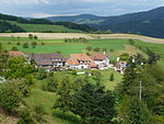
Core city and Atzenbach
In the south of the urban area, Zell extends on both sides of the meadow. The Liebeck residential area is on its right bank, and the Schwarznau on the left bank , where there is a large industrial area with plants from the Mahle and Benninger companies. The federal road 317, which comes from Hausen, runs through the town along the left bank of the meadow. Shortly after the former hospital, the actual core town on the right bank of the meadow and the slopes behind it is reached via the Wiesebrücke. This is where the two main streets of Zeller cross, the Schopfheimer Straße running in north-south direction and the Schönauer Straße coming from the east . The town hall, the Sparkasse Wiesental office building and Constanze-Mozart-Gasse (formerly Rathausgasse ) with the Zeller Carnival Fountain are in the immediate vicinity of the intersection . To the north of this is the Catholic parish hall and the Church of St. Fridolin, further to the west there is a small park with the swan pond .

A nursing home and old people's home was built a little west of the city center on Hans-Fräulin-Platz near the Old Catholic Church; To the south-west of this is the Zeller Stadtpark with the Protestant church at its western end. A little above this is the school grounds in Zell with the Gerhard Jung School , the Montfort Realschule , the Johann Faller Förderschule and the sports hall. The Zell train station is located even further south-west of the schools; Around it is another industrial park with a Mahle plant to the north and Zellaerosol GmbH to the south of the track system. To the southeast of the city center, between Wiese and the city center, is the Webi -Areal, on which the former weaving mill of Zell-Schönau AG stood. In the meantime, several supermarkets, the textile museum (see below) and some smaller businesses have settled here. Further to the east, the city narrows quite sharply between the meadow and the mountain slope, before it widens again significantly for the residential area of Greenland in the northeast of the city area. In Greenland, the Zeller road network also connects to the B317 (which from now on runs along the right bank), and Atzenbach extends east of it, although due to the elongated building of the former Atzenbach spinning mill, it is difficult for the observer to establish a structural boundary between the City and the district can be perceived. Atzenbach lies in a bend in the meadow and is completely traversed by the B317; The majority of the village is on the right bank between the main road and the river, the Catholic church in the south and an industrial area at the northern exit of the village, however, extend on the left bank. The Atzenbacher sports hall is located near the exit of the town in the north.
Further districts
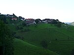
To the west and above Zell is the village of Adelsberg. In addition to the village, the former municipality of Adelsberg also included the Zinken Blauen, a little north of Adelsberg on the slope of the mountain of the same name. West of Adelsberg and a little higher is Gresgen. The westernmost district of Zell extends on a plateau and borders on Tegernau, Enkenstein and Hausen. Important buildings are on the one hand the slightly raised Protestant church, on the other hand the "Citizens' Center", which is located in the south of the village and was built in 1999, which serves as a sports and festival hall as well as the seat of the local administration. Gresgen received the rating of a resort from the regional council . The Henschenberg lies between Zell and Adelsberg; In addition to the courtyards Unterer and Oberer Henschenberg, there is also the ruin of a medieval castle , of which a half-ditch, wall remains and brick and ceramic rubble can still be seen today.
Adelsberg

The Zinken Blauen belonging to Adelsberg with the mountain of the same name

Gresgen


Besides Zell and Atzenbach, Mambach is the only district that is not located on the mountain ranges around the town, but in the valley of the meadow. It is located about 2 kilometers north of Atzenbach and extends on both sides of the river. Like Atzenbach and Zell, Mambach is crossed by the federal highway 317, which runs along the left bank. The Maria Frieden chapel, built on the “Scheibenackerköpfle” to the west of the village, is visible from afar; The older Antonius Chapel is located in the village itself. Erected from sandstone, it also protrudes clearly from the rest of the village. To the northwest and well above Mambach is the village of Pfaffenberg, which can best be reached from Atzenbach. The Zinken Käsern also belonged to the former municipality of Pfaffenberg, further to the north-west. Finally, Riedichen is the only part of Zell that is located in the mountains to the east of the city. The Zinken Gaisbühl also belonged to the municipality of Riedichen.

Mambach
Pfaffenberg

Riedichen


Churches
There are 4 churches and chapels in the town of Zell itself. The Catholic parish church of St. Fridolin with the year 1545 carved in the archway is located in the center of the Zell city center. The church tower was rebuilt in 1699. After the town fire of 1818, the church was rebuilt from scratch from 1820 to 1823. Further alterations were made in the second half of the 19th century (pointed roof), in 1883 (new main altar), and in 1884 (covered with green glazed tiles). In 1994 the final redesign of the chancel and the nave was completed. The Evangelical City Church of St. Peter on the edge of the city park has a 35.8 meter high tower with a pointed helmet and copper roofing. Halfway up the tower there is a circumferential balcony from which trumpets used to be heard on high feast days. The church tower clock has existed since 1893, and a new sacristy was added between 1956 and 1960. The "Christ Church" is the former old Catholic parish church used on special occasions (including weddings) . The interior height of the nave is 7.20 meters, the tower is 32 meters high. For the 100th anniversary of the church in 1992, the altar was restored to the furnishings from 1892. On the side end walls in front of the choir, large paintings depict the Ascension of Christ and Mary with the child. On the left bank of the meadow, the Kalvarienbergkapelle was also built in 1889 on a ledge on the way to the Möhrenberg in place of a dismantled previous building.

Calvary Chapel


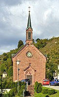
Other churches are located in the districts: The Catholic parish church of the Assumption of Mary was built in Atzenbach in 1928. It has a wide transept and a rather short nave, the center is vaulted with a dome. The churches in Mambach also belong to the parish of Atzenbach: The Antonius chapel was built in 1871 from red sandstone in the style of historicism and is located on a small hill in the middle of the village. 1946 was also on the Scheibenacherköpfle between Mambach and Pfaffenberg the chapel Maria Peace built in thanks for the end of World War II and for being spared from severe war damage. According to documents, there was already a church in Gresgen in 1267, which was probably consecrated to St. Nicholas . In 1763 a new building was necessary, which is still in place today after renovations in 1980/81.
Antonius Chapel Mambach

Maria Frieden chapel above Mambach


Textile museum and game reserve

The Wiesentäler Textile Museum , opened in 1996, provides information on the development of the textile industry , which has been the most important economic sector in the region since the middle of the 19th century. The operational exhibits from the history of textile production include mechanical looms , spinning machines , weft winding machines and dyeing machines. The development stages from home work to the factories to industrial production are shown in an image documentation .
Slightly above the residential area Schwarznau was established in 1971 as a private initiative a game reserve, which now fallow deer and red deer and wild boar can be seen. The area of the enclosure is 3.6 hectares.
Regular events
Zell carnival
.jpg)
The Zell Carnival is the largest folk festival in Zell im Wiesental. It was first mentioned in a document in 1627 and thus has a very long tradition. Until the 19th century, the carnival was carried out without any organizational structures. It was not until the middle of the 19th century that individual events such as “demonstrations”, “colorful evenings” or “carnival dances” were organized by local associations. Since at least 1927 the organization of the Zell Carnival has been the responsibility of the Zell Carnival Society. The Zeller Fasnacht is not borne by the carnival society, but by the individual districts, which organize themselves in so-called bailiwicks. The oldest of these bailiwicks is the Greenland Valley Bailiwick, founded in 1897. The bailiwicks hold their bailiwick evenings or “Chappeobe” annually before the actual street carnival. The audience is entertained in tavern halls or in the town hall. The head of the Zell carnival is the "Hürus". His term of office begins on “Ölfte Ölfte”, November 11th, when the Zell Carnival begins. The term of office of the Hürusses ends on Shrove Tuesday, exactly midnight. The figure of Hüruss is related to the history of Zell: The gentlemen of Schönau, who exercised the office of Meier over Zell, were mostly nicknamed Hürus for centuries, which means something like "proud, powerful man". Another specialty of the Zell Carnival is the “Altwiiberrenne”, which has been taking place on the evening of Carnival Tuesday in Kirchstrasse for almost a hundred years. The participating "old women" are usually disguised young men who master an obstacle course.
Zell open-air theater
Since 1996 the Zeller Trachtengruppe has been organizing the Zeller Freilichtspiele , which take place every few years. The initiator of these theater performances was the local poet from Zell, Gerhard Jung , who dedicated the revolutionary play “A Day in April” to his home town in 1996 on the occasion of his 70th birthday. In the same year the piece was performed on the site of the former weaving mill. Over 7,000 visitors saw the Jungsche play, which was based on the entry of the revolutionary groups around Georg Herwegh into Zell in April 1848. After this great response, “Ein Tag im April” was performed again in 1998, 150 years after the Baden Revolution .
So far the following have been performed at the Zeller Freilichtspiele:
- One day in April (Gerhard Jung, 1996 and 1998)
- Montfort or the first factory in Zell (Gerhard Jung, 2004)
- A Midsummer Night's Dream (William Shakespeare, 2007)
- The happy vineyard ( Carl Zuckmayer , 2010)
Sports and clubs
Numerous associations in Zell are associated with the Zell Carnival. In addition to the "Vogteien" Mittelstadt, Obertal, Sunneland, Greenland, Innegmei, Paradies, Schwyz, Adelsberg, Gresgen, Riedichen, Mambach and the Atzenbach fools' guild there are the music formations of the "Fanfarenzuges" and the Guggen music "Zeller Noteknacker". In addition to these two clubs, numerous other clubs are dedicated to music: There are brass bands in Zell (“town music”), Mambach (“fire brigade music ”), Gresgen and Atzenbach . The parishes of Zell and Atzenbach have their own church choirs, which have been operating as a choir community since 2012, and there are male choirs and choirs in Atzenbach, Zell, Gresgen, Riedichen and Pfaffenberg.
There are several sports facilities in the city of Zell. A soccer field with an athletics facility was built on the “Grendel” between Hausen and Zell, there are sports halls in the city of Zell itself in the school district and near the train station and in the suburbs of Atzenbach and Gresgen. In the northeast of the urban area, in "Greenland", there is also an outdoor swimming pool and a tennis facility not far away. These sports facilities are used by various clubs: In the city center there is the soccer club FC Zell, the tennis club TC Zell, the sports clubs SC and TV Zell and the ring community Hausen-Zell, which emerged from a merger of two clubs . There is another sports club (which is heavily dedicated to wrestling ) in Gresgen. In the Schützengesellschaft 1862 eV, archery as well as archery is practiced, whereby the Zeller archers have already made German runners-up. Other clubs are dedicated to fishing and dog sports as well as small animal breeding, there are also local groups of the German Red Cross , the DLRG and the Black Forest Association . Other associations with social and caring purposes are the Zeller Kolping Family , the Arbeiterwohlfahrt , the association "Cabanja" for peace and development, the VdK and the Turkish-Islamic cultural association "Diyanet".
Economy and Infrastructure
Land use
290 hectares of the Zell district are designated as settlement and traffic areas, which corresponds to around 8% of the district area. The extensive distribution of the Zell suburbs across the Zeller Bergland is reflected in a large forest area, which makes up almost two thirds of the entire district (2347 hectares). 950 hectares or 26.3% of the district are designated as agricultural area.
Established businesses

In 2009 there were four manufacturing companies in Zell, which together employed 769 people. The most important local employer is the automotive supplier Mahle GmbH . The origin of the Zeller Mahle location is the Carl Pleus company, which was founded in Krefeld in 1919 and relocated to Zell in the course of the Second World War. Also of importance are the cell aerosol mentioned in the history of the diversification of a textile company and the location of Benninger AG , which was created in 1991 through the acquisition of the Krückels machine factory. Since 1855 there had been a branch of the district savings bank Schönau in Zell , in 1898 the Sparkasse Zell iW was founded, which merged with the Sparkasse Atzenbach in 1913 and in 2018. Other guarantor communities were Adelsberg, Atzenbach, Mambach, Pfaffenberg and Riedichen, from 1928 also Gresgen and Hausen and ab in the 1970s also Häg; After the municipal mergers in the course of the administrative reform, this number was reduced to Zell, Hausen and Häg-Ehrsberg. In 2003 the Sparkasse Zell iW merged with the Sparkasse Schopfheim to form the Sparkasse Schopfheim-Zell; Before its merger, the Zeller Sparkasse was the smallest savings bank in Baden-Württemberg, but was considered profitable. In 2017 the Sparkasse Schopfheim-Zell merged with the Sparkasse Schönau-Todtnau to form Sparkasse Wiesental . Another banking business in Zell was opened in 1953 with the branch of Volksbank Schopfheim (today VR Bank Schopfheim- Maulburg ). Crafts (1995: 50 companies with 347 employees) and trade and hospitality (1993: 69 companies with 421 employees) are also important. The number of overnight stays was 16,000 in 2010. There are also 74 farms, the majority of which are part-time. The average farm size of these farms is 13 hectares, the focus is on livestock farming, especially cattle, chickens and sheep. As a result, almost the entire agricultural area is permanent grassland, only 1 percent is used as arable land. All in all, a large part of the Zell population still works outside the municipal boundaries: in 2010 there were 828 professional commuters compared to 1,638 out-commuters.
traffic

The city is connected to Lörrach and Basel from the station in Zell (Wiesental) with the Wiesentalbahn (line S6 of the S-Bahn Basel ) ; it also has some local and regional bus connections . It belongs to the Regio Verkehrsverbund Lörrach . From 1889 to 1967, a narrow-gauge railway also ran from Zell to Todtnau , which also served stops in the Atzenbach and Mambach districts.
The federal highway 317 ( Weil am Rhein - Titisee-Neustadt ) along the valley axis of the Wiesental connects Zell with the national road network. The side valleys of the mountainous district are accessed via numerous district and state roads. One of the highest passes in the district, the St. Antoni Pass , leads from Mambach from Zell to Todtmoos in the neighboring district of Waldshut .
education
In addition to the Montfort Realschule and a primary school (Gerhard-Jung-Schule) - Werkrealschule until 2018 - in the core city there are primary schools in Atzenbach and Gresgen. The Johann-Faller - special school and a Sprachheilschule complete the training program. The closest grammar schools are the Schönau grammar school and the Theodor-Heuss grammar school Schopfheim . There are three municipal and one Protestant kindergarten for the youngest residents. In 1998, the SRH Fernhochschule opened a study center in Constanze-Weber-Gasse, where students from the Fernhochschule have the opportunity to attend accompanying events, take exams and obtain information on site.
Personalities

Franz Fridolin Weber was born in Zell in 1733 as the son of the bailiff. In 1754, when he was only 21, he was also appointed bailiff by Baron Ignaz Ludwig von Schönau, and in 1756 he married Cäcilia Stamm, who came from Mannheim. At the beginning of the 1760s there were disputes between the bailiff and the baron, as a result of which Weber moved to Mannheim in 1764. About a year and a half earlier, on January 5, 1762, Weber's daughter Constanze was born in Zell, who later married Wolfgang Amadeus Mozart . Another daughter of Weber, born in Zell, was the singer and singing teacher Aloisia Lange , who was born in the city between 1759 and 1761. Johann Faller was born in Todtnau, but worked in a responsible position in the Zell textile industry and campaigned for social issues in Zell, including founding a reading society and the Zell fire brigade, with financial support for associations and with cheap loans for housing construction. As a member of the Second Chamber of the Baden Estates Assembly , he also had several roads built in the Upper Wiesental.
Severin Kern (1900–1986) was Lord Mayor of Villingen from 1950 to 1972.
In 1903 Karl Müller was born in Zell as the son of a textile worker. Persecuted as a trade unionist and communist during National Socialism , imprisoned and forced to serve in Penal Battalion 999 , after his release from Soviet captivity, he became a member of the SED and editor of the Sächsische Zeitung .

Gerhard Jung (1926–1998) was born on August 10, 1926 in Zell. He became known as a dialect poet and writer in Wiesental and beyond and received the Johann-Peter-Hebel-Badge of the community of Hausen in 1973, and in 1974 the Johann-Peter-Hebel-Prize of the State of Baden-Württemberg. In 1997, Jung was also awarded the Federal Cross of Merit, and since 1986 he has been an honorary citizen of his hometown. Jung's son Markus Manfred was also born in Zell. Like his father, he is known as a dialect poet and writer.
The bank manager and art collector Manfred Meier-Preschany , who was born here on January 21, 1929, also comes from Zell .
In addition to Gerhard Jung, the city of Zell has granted honorary citizenship to five other men: Karl Fritz was born in Adelhausen , but came from a Pfaffenberg family and spent part of his youth there. After finishing theology studies he celebrated on July 12, 1888 in Zell his first Mass , other stations 1920 he was archbishop of Freiburg. He celebrated his forty-year jubilee as a priest in Zell in 1928 and received honorary citizenship on this occasion. Karl Bernhard Wittig had initially worked in the Zimmerlin-Forcart spinning mill, but went into business for himself in 1885 and founded a textile machine factory. For his industrial as well as social services he was granted honorary citizenship in 1935. The third honorary citizen was Bernhard Lederer, who was Mayor of Zell from 1957 to 1985. Hans Fräulin was made an honorary citizen in October 1995. Fräulin had been active as a local politician for many years and had been very committed to the construction of the Zeller Bürgerheim. The place where the community center is located was named after him. In addition, he was involved in homeland maintenance and local research and was the author of the local history book published in 1999. Franz Wolfgang Leppert was made an honorary citizen at the New Year's reception in 2006 because of 30 years of pastor's Catholic parish St. Fridolin in Zell.
Other sons and daughters of the city
- Franz Anton von Weber (1734–1812), conductor
- Aloisia Lange (between 1759 and 1761–1839), soprano and vocal teacher
- Josepha Hofer (1761–1819), soprano
- Franz Joseph Dietschy (1770–1842), brewery entrepreneur from Pfaffenberg
- Rudolf Vogel (1882–1970), materials researcher and metallograph
- Hermann Specht (1892–1968), District Administrator in Heidelberg, Member of Parliament
- Fritz Eiche (1902–1967), politician (KPD)
- Karlheinz Weber (* 1934), correspondence chess player
- Carola Horstmann (* 1948), dialect author and local poet
- Michaela Fuchs (* 1949), classical archaeologist
- Heidi Knoblich (* 1954), novelist, children's book author and playwright, speaker
- Arnulf Krause (* 1955), Medievalist
literature
- Guido Fackler : D'Webi dies - on the current crisis in the textile industry in the Wiesental, on the Upper and Upper Rhine. In: Brigitte Heck, Heidi Müller, Friederike Lindner, Guido Fackler: Between School and Factory. Textile women's work in Baden in the 19th and 20th centuries (= folklore publications of the Badisches Landesmuseum Karlsruhe. Volume 1). Thorbecke, Sigmaringen 1993, ISBN 3-7995-0300-5 , pp. 163-174.
- Hans Fräulin: New history of the city of Zell im Wiesental. Self-published by the city of Zell im Wiesental, Zell im Wiesental 1999, ISBN 3-932738-13-6 .
- Hans Fräulin: Zell im Wiesental from then until today. In: Das Markgräflerland, issue 1/1992, pp. 5–17 ( digitized version from Freiburg University Library ).
- Theodor Humpert : Local history of the district of Schönau i. W. General edition. Müller, Schönau im Wiesental 1920.
- Department of State Description of the State Archives Freiburg im Breisgau: The district of Lörrach. Volume 2: B. Community descriptions Kandern to Zell im Wiesental. Edited by the Baden-Württemberg State Archives Directorate in conjunction with the Lörrach district. Jan Thorbecke Verlag, Sigmaringen 1994, ISBN 3-7995-1354-X .
- Uli Merkle: That's how it is for me - the Zell Carnival. Self-published by Uli Merkle, Zell 2006.
- Werner von Schönau-Wehr, Katharina Frings (Hrsg.): Nobility on Upper and High Rhine. Contributions to the history of the barons of Schönau. Rombach, Freiburg (Breisgau) 2001, ISBN 3-7930-9282-8 .
- Uli Merkle: Go to heaven via Gresgen - hiking book for the most beautiful hikes to Gresgen and the surrounding mountains. Self-published by Uli Merkle, Zell 2014, ISBN 978-3-00-044760-0 .
- Pirmin Rottler: Zell im Wiesental - border town between Upper Austria and Margraviate. In: The Markgräflerland. Issue 2/1967, pp. 48–53 ( digitized version of the Freiburg University Library ).
- Heidi Knoblich: The highly musical Weber family in Zell. Constanze Mozart and Carl Maria von Weber's father were born in the former administrative building in Zell. In: The Markgräferland. Edited by the Geschichtsverein-Markgräflerland e. V. issue 1/2015, pp. 94-109.
Web links
- Official website of the city of Zell
- Regional information system for Baden-Württemberg (LeoBW): Zell im Wiesental - archive material
- Website Zeller Bergland Tourismus eV
- Wiesentäler Textile Museum
- Atzenbach district website (currently unavailable)
- Website of the Pfaffenberg district
- Website about the Todtnauerli. (No longer available online.) In: todtnauerli.de. Benno Dörflinger, archived from the original on October 8, 2016 (private website).
Remarks
- ↑ State Statistical Office Baden-Württemberg - Population by nationality and gender on December 31, 2018 (CSV file) ( help on this ).
- ↑ Lörrach district, p. 925.
- ↑ Fräulin, New History of the City of Zell im Wiesental , p. 28.
- ↑ Lörrach district, p. 886.
- ↑ district Loerrach, p 893ff.
- ^ The state of Baden-Württemberg. Official description by district and municipality. Volume VI: Freiburg administrative region. Kohlhammer, Stuttgart 1982, ISBN 3-17-007174-2 , pp. 910-913.
- ↑ Fräulin, Neue Geschichte der Stadt Zell , p. 16.
- ↑ Internet presence of the city of Zell: Adelsberg .
- ↑ Internet presence of the city of Zell: Atzenbach .
- ↑ Internet presence of the city of Zell: Riedichen
- ^ Lörrach district, p. 885 ff.
- ↑ a b Lörrach district, p. 887.
- ^ Deutscher Wetterdienst : mean values for the normal period 1961 to 1990 .
- ↑ Data evaluation sheet NP 6 - Southern Black Forest, accessed on June 16, 2012 from the data and map service ( memento from April 19, 2013 in the Internet Archive ) of the State Environmental Authority of Baden-Württemberg (map no longer available).
- ↑ Data evaluation sheet FFH 8213341 - Weidfelder im Oberer Wiesetal, accessed on June 16, 2012 from the data and map service ( memento from April 19, 2013 in the Internet Archive ) of the Baden-Württemberg State Environmental Authority (data no longer available).
- ↑ Data evaluation sheet FFH 8312341 - Röttler Wald, accessed on June 16, 2012 from the data and map service ( memento from April 19, 2013 in the Internet Archive ) of the Baden-Württemberg state environmental authority (data no longer available).
- ↑ Data evaluation sheet SPA 8114441 - Southern Black Forest, accessed on June 16, 2012 from the data and map service ( memento of April 19, 2013 in the Internet Archive ) of the State Environmental Authority of Baden-Württemberg (data no longer available).
- ↑ Datenauswertebögen to END 83361030003, END 83361030002 END 83361030001, FND 83361030007, FND 83361030006, FND 83361030005 and FND 83361030006, accessed on 16 June 2012 from data and mapping service ( Memento of 19 April 2013, Internet Archive ) of the State Environmental Protection Agency Baden-Württemberg (Data no longer available).
- ↑ Lörrach district, p. 925.
- ↑ Fräulin, New History of the City of Zell im Wiesental , p. 28.
- ↑ Lörrach district, p. 920 ff.
- ^ Lörrach district, p. 922.
- ↑ Fräulin, New History of the City of Zell im Wiesental , p. 65.
- ↑ Fräulin, New History of the City of Zell im Wiesental , p. 34 ff.
- ↑ Klaus Schubring : Where was Altenstein Castle? In: The Markgräflerland. Volume 1/2012, pp. 106-117. For the assignment to the Henschenberg: Andre Gutmann: Under the coat of arms of Fidel. The Lords of Wieladingen and the Lords of Stone between ministerialism and aristocratic rule With the collaboration of Christopher Schmidberger (= research on the history of the Upper Rhine region. Volume 55), Freiburg i. Br./München 2011, p. 320 f. ( Full text as PDF ).
- ↑ Fräulin, New History of the City of Zell im Wiesental , pp. 67 and 74.
- ↑ Fräulin, New History of the City of Zell im Wiesental , pp. 53–56.
- ↑ Fräulin, New History of the City of Zell im Wiesental , p. 139.
- ↑ The Hinterhag in the beautiful Angenbachtal on hinterhag.de .
- ↑ Fräulin, New History of the City of Zell im Wiesental , p. 141 f.
- ↑ Fräulin, New History of the City of Zell im Wiesental , pp. 147–150.
- ↑ Fräulin, New History of the City of Zell im Wiesental , p. 338 ff.
- ↑ Lörrach district, pp. 905 and 931.
- ↑ Fräulin, New History of the City of Zell im Wiesental , p. 385f. and 339.
- ↑ Fräulin, New History of the City of Zell im Wiesental , p. 42.
- ↑ Ernst Rümmele, Der Hinterhag , p. 136 f.
- ↑ Ernst Rümmele, Der Hinterhag , p. 69.
- ↑ Fräulin, New History of the City of Zell im Wiesental , p. 263.
- ↑ Landkreis Lörrach, p. 922 and p. 927.
- ↑ Fräulin, New History of the City of Zell im Wiesental , pp. 150–157.
- ↑ Fräulin, New History of the City of Zell im Wiesental , pp. 368–380.
- ↑ Fräulin, New History of the City of Zell im Wiesental , pp. 158–163.
- ↑ Fräulin, New History of the City of Zell im Wiesental , p. 163.
- ^ Lörrach district, p. 897 f.
- ↑ Fräulin, New History of the City of Zell im Wiesental , pp. 368–372.
- ↑ Fräulin, New History of the City of Zell im Wiesental , pp. 377 and 382.
- ↑ Fräulin, New History of the City of Zell im Wiesental , pp. 388 and 394.
- ↑ Fräulin, New History of the City of Zell im Wiesental , pp. 368, 372 and 395.
- ↑ Fräulin, New History of the City of Zell im Wiesental , p. 166.
- ↑ a b c Lörrach district, p. 908.
- ↑ Fräulin, New History of the City of Zell im Wiesental , pp. 165 ff.
- ^ Lörrach district, p. 898.
- ↑ Fräulin, New History of the City of Zell im Wiesental , p. 373.
- ↑ Fräulin, New History of the City of Zell im Wiesental , pp. 373 and 377.
- ↑ Fräulin, New History of the City of Zell im Wiesental , pp. 169–173.
- ^ Lörrach district, p. 901.
- ↑ Fräulin, New History of the City of Zell im Wiesental , p. 178.
- ↑ Fräulin, New History of the City of Zell im Wiesental , pp. 175–179.
- ↑ Deportation sites. In: mahnmal.kja-freiburg.de, Specialist Office for Christian-Jewish Memorial Work of the Christian Youth Work of the Archdiocese of Freiburg, accessed on July 22, 2019.
- ↑ Fräulin, New History of the City of Zell im Wiesental , p. 180.
- ↑ Lörrach district, p. 90.
- ↑ Fräulin, New History of the City of Zell im Wiesental , pp. 370, 373 f.
- ↑ Fräulin, New History of the City of Zell im Wiesental , p. 370.
- ↑ Fräulin, New History of the City of Zell im Wiesental , p. 374.
- ^ Fackler, D'Webi dies , p. 167.
- ↑ Fräulin, New History of the City of Zell im Wiesental , pp. 374 and 379.
- ↑ Fräulin, New History of the City of Zell im Wiesental , p. 379.
- ↑ a b c Fackler, D'Webi dies , p. 166.
- ^ Federal Statistical Office (ed.): Historical municipality directory for the Federal Republic of Germany. Name, border and key number changes in municipalities, counties and administrative districts from May 27, 1970 to December 31, 1982 . W. Kohlhammer, Stuttgart / Mainz 1983, ISBN 3-17-003263-1 , p. 498 and 521 .
- ↑ a b c d e f State Statistical Office Baden-Württemberg: Structural and regional database .
- ^ Lörrach district, p. 898 f.
- ↑ Rümmele, p. 136 ff.
- ↑ Fräulin, New History of the City of Zell im Wiesental , p. 266.
- ↑ Pastoral care unit in Zell im Wiesental .
- ↑ Fräulin, New History of the City of Zell im Wiesental , pp. 304–308.
- ↑ Fräulin, New History of the City of Zell im Wiesental , p. 270.
- ↑ Fräulin, New History of the City of Zell im Wiesental , pp. 318–322.
- ↑ Fräulin, New History of the City of Zell im Wiesental , p. 324.
- ↑ Statistics BW: Local elections 2019
- ^ Lörrach district, p. 901.
- ↑ Fräulin, New History of the City of Zell im Wiesental , p. 413.
- ^ Lörrach district, p. 902.
- ↑ Lörrach district, p. 884.
- ^ Website of Zell - twin town
- ↑ a b Internet presence of the city of Zell: Gresgen . Retrieved July 22, 2019.
- ↑ Lörrach district, p. 895.
- ↑ a b c d e Internet presence of the city of Zell iW: Kirchen-Dorfkirchen-Kapellen .
- ^ Lörrach district, p. 896.
- ↑ a b Lörrach district, p. 897.
- ↑ Internet presence of the city of Zell iW: Sights .
- ↑ Uli Merkle: The history of the Zell carnival. In: The Markgräflerland. Volume 1/2015, pp. 110-123.
- ↑ Internet presence of the Fastnachtsgesellschaft Zell: Vogteien. In: zeller-fasnacht.de, accessed on July 22, 2019 (with map).
- ^ Paul Berger: Church choirs Zell and Atzenbach merge. In: Badische Zeitung. May 9, 2012, accessed May 22, 2019.
- ↑ a b c Internet presence of the city of Zell iW: Club life .
- ↑ Fräulin, New History of the City of Zell im Wiesental , p. 385 ff.
- ↑ Fräulin, New History of the City of Zell im Wiesental , p. 390.
- ↑ Fräulin, New History of the City of Zell im Wiesental , pp. 356-360.
- ↑ Fräulin, New History of the City of Zell im Wiesental , p. 360.
- ↑ Inside-B Magazin, May 2006, p. 48 (PDF; 791 kB). ( Page no longer available , search in web archives ) (no mementos).
- ↑ Fräulin, New History of the City of Zell im Wiesental , p. 361.
- ↑ Study Center Zell im Wiesental | SRH Fernhochschule. Retrieved January 9, 2020 .
- ↑ Milestones | SRH Fernhochschule. Retrieved January 9, 2020 .
- ↑ Fräulin, New History of the City of Zell im Wiesental , pp. 58–63.
- ↑ Internet presence of the city of Zell: Johann Faller .
- ↑ Andreas Herbst: Müller, Karl . In: Who was who in the GDR? 5th edition. Volume 2. Ch. Links, Berlin 2010, ISBN 978-3-86153-561-4 .
- ↑ Fräulin, New History of the City of Zell im Wiesental , p. 421.
- ↑ Fräulin, New History of the City of Zell im Wiesental , p. 421 f.
- ↑ Fräulin, New History of the City of Zell im Wiesental , p. 422.
- ↑ Fräulin, New History of the City of Zell im Wiesental , p. 422 f.

Aitern | Bad Bellingen | Binzen | Böllen | Efringen churches | Eimeldingen | Fischingen | Happy | Grenzach-Wyhlen | Häg-Ehrsberg | Hazel | Hausen im Wiesental | Inzlingen | Kandern | Small meadow valley | Loerrach | Malsburg-Marzell | Maulburg | Rheinfelden | Rümmingen | Schallbach | Schliengen | Schönau in the Black Forest | Schönenberg | Schopfheim | Schwörstadt | Stones | Todtnau | Tunau | Utzenfeld | Because on the Rhine | Wembach | Wieden | Whiting | Zell im Wiesental