
Whiting
| coat of arms | Germany map | |
|---|---|---|

|
Coordinates: 47 ° 39 ' N , 7 ° 39' E |
|
| Basic data | ||
| State : | Baden-Württemberg | |
| Administrative region : | Freiburg | |
| County : | Loerrach | |
| Height : | 304 m above sea level NHN | |
| Area : | 4.5 km 2 | |
| Residents: | 942 (December 31, 2018) | |
| Population density : | 209 inhabitants per km 2 | |
| Postal code : | 79599 | |
| Area code : | 07621 | |
| License plate : | LÖ | |
| Community key : | 08 3 36 100 | |
| LOCODE : | DE WYG | |
| Address of the municipal administration: |
Rathausplatz 1 79599 Wittlingen |
|
| Mayor : | Michael Herr | |
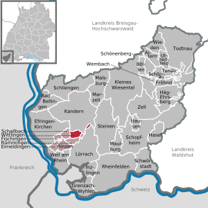
| Location of the municipality of Wittlingen in the district of Lörrach | ||
  |
||


Wittlingen (Alemannisch Wittlige ) is a municipality in the district of Lörrach in Baden-Württemberg . Apart from the village of the same name, no other villages belong to the municipality of Wittlingen. The place is a member of the community administration association Vorderes Kandertal based in Binzen .
geography
Geographical location
Wittlingen is located in the lower Kandertal in the Markgräflerland north of Lörrach . The municipality is located on the eastern edge of the Bamlach-Schallbacher Lösshügelland. The highest point of the community is located in the district exclave in the Röttler forest at 571 meters above sea level. NN in the win high stand.
Neighboring communities
The community borders in the north on the Wollbach district of the city of Kandern , in the east on the district town of Lörrach , in the south on Rümmingen and in the west on Schallbach .
Historical geography
The Crensheim desert and the defunct St. Martin's Church are in the municipality .
history
Until the 19th century
Archaeological finds suggest that the Alemanni were first settled before the village came into Franconian hands around 600.
Wittlingen was first mentioned as Witringhove in a document from the St. Gallen monastery in 874 . In other documents the names Witelichon and Wittlikeim appeared before the current place name prevailed in the 16th century. The monastery had extensive property in Whiting and the entire region, which was lost to the diocese of Basel and other rulers in the High Middle Ages as a result of the fighting with the Habsburgs .
In 1503 the village became part of the margraviate of Baden and with this in 1806 it became part of the newly founded Grand Duchy of Baden .
It is no coincidence that the pumpkin was used to name the carnival clique. Because this thick, round plant was preferably grown in the community a long time ago. In the famous handwriting of the Röttler Oberamtmannes von Leutrum, that excellent description of the margraviate from the early 18th century, Whiting is portrayed as a village with many poor who eat poorly and everything that "grows on fields, meadows and vines" is their own highest necessity ”. The margravial superintendent wrote literally: "Whiting are called pumpkin eaters, presumably out of poverty and because they are not particularly capable of planting better fruit".
Population development
At the end of the 17th century the population was around 160, and by the end of the 18th century it had risen to around 240. The population development of Whiting over the last 200 years is as follows:
| year | 1804 | 1852 | 1910 | 1933 | 1987 | 1991 | 1995 | 2005 | 2010 | 2015 |
|---|---|---|---|---|---|---|---|---|---|---|
| Residents | 288 | 339 | 277 | 327 | 647 | 697 | 765 | 958 | 965 | 978 |
politics
Municipal council

The municipal council in Wittlingen has eight members. It consists of the voluntary councilors and the mayor as chairman. The mayor is entitled to vote in the municipal council. In the local elections on May 26, 2019, the local council was elected by majority vote. Majority voting takes place if no or only one nomination has been submitted. The applicants with the highest number of votes are then elected. The turnout was 69.0% (2014: 57.6%).
The town council is headed by the mayor Michael Herr. He was re-elected in July 2015 with 97.3% of the vote.
coat of arms
The municipality's coat of arms shows in a split shield in front in gold (yellow) a red sloping bar and thus refers to the affiliation to the state of Baden ; behind is a golden (yellow) ploughshare on a blue background and symbolizes agriculture. The municipality has had the coat of arms since 1906 at the suggestion of the Baden General State Archives.
societies

- FC Wittlingen 1954 eV
- Chürbse-Clique Wittlingen 1978 eV
Culture and sights
In the center of the village of Wittlingen is the church of St. Michael , which was built from 1772 to 1774 according to plans by Wilhelm Jeremias Müller on the foundations of a Gothic hall church . It is considered to be the forerunner of the small church in Karlsruhe . To the east of the church is the cemetery.
To the north of the church is the almost square, two-story rectory. The town hall from the 1930s is located at the intersection of Kirchstrasse and Rathausstrasse.
Economy and Infrastructure
traffic
Until 1983, Wittlingen was connected to the national rail network via the Kandertal Railway from Haltingen to Kandern . Today only a museum train , called Chanderli , runs there . The place is a bus stop in the local public transport of the SWEG .
Landstrasse 134 runs through the village along the Kandertal and connects Binzen with Kandern. From Rümmingen, the town is connected to the national road network via the 141 road with the A 98 via the Kandern junction.
From the town center, the county road 6344 branches off from the country road over a small mountain pass called Wittliger Buck (437 meters above sea level) in the direction of Haagen and front Wiesental . In the settlement area of the village- like structure of the place, the streets form a square.
economy
Until well into the middle of the 20th century, Whiting was a heavily agricultural village. The agricultural area grew from 163 hectares in 1895 to 180 hectares in 1930 until after some fluctuations it leveled off at 142 hectares in 1985. The grassland area was 44 hectares and the arable land was 83 hectares. The most important branches of agriculture were the cultivation of grain, the cultivation of root crops and fruit growing. In the second half of the 19th century, livestock farming in particular expanded.
To this day, Wittlingen has no industrial operations and only a few craft businesses. In 1895 twelve people were organized in seven commercial establishments. The largest commercial steel construction company was a company founded in 1961, which went bankrupt in 1993. The service and tourism sector is also weak in Whiting. Markets never formed in Wittlingen.
literature
- Department of State Description of the State Archives Freiburg im Breisgau: The district of Lörrach. Volume 2: B. Community descriptions Kandern to Zell im Wiesental. Published by the Baden-Württemberg State Archives Directorate in conjunction with the Lörrach district. Jan Thorbecke Verlag Sigmaringen 1994, ISBN 3-7995-1354-X , pp. 868-883.
- Eugen Eble: Ortssippenbuch Wittlingen, district Lörrach in Baden. Grafenhausen: Albert Köbele 1966 (= Badische Ortssippenbücher 16), processed period 1583–1964
Web links
- Regional information system for Baden-Württemberg : Altgemeinde, suburb of Wittlingen - archive material
Individual evidence
- ↑ State Statistical Office Baden-Württemberg - Population by nationality and gender on December 31, 2018 (CSV file) ( help on this ).
- ^ Department of State Description of the State Archives Freiburg im Breisgau: Der Landkreis Lörrach. Volume 2: B. Community descriptions Kandern to Zell im Wiesental. 1994, p. 868, gives 428 meters because the exclave is not taken into account.
- ^ Landesarchivdirektion Baden-Württemberg (ed.): Das Land Baden-Württemberg. Official description by district and municipality. Volume 6: Freiburg administrative region. Kohlhammer, Stuttgart 1982, ISBN 3-17-007174-2 , p. 833.
- ^ Department of State Description of the State Archives Freiburg im Breisgau: Der Landkreis Lörrach. Volume 2: B. Community descriptions Kandern to Zell im Wiesental. 1994, p. 881.
- ^ Department of State Description of the State Archives Freiburg im Breisgau: Der Landkreis Lörrach. Volume 2: B. Community descriptions Kandern to Zell im Wiesental. 1994, p. 871.
- ↑ Preliminary results of the 2019 municipal council elections at the State Statistical Office
- ↑ http://www.verlagshaus-jaumann.de/inhalt.wittlingen-97-3-der-stimmen-fuer-michael-herr.4105ef22-1fe7-4103-9c9b-b0a89a6ee40e.html
- ↑ Harald Huber: Wappenbuch Landkreis Lörrach. Verlag des Südkurier, Konstanz 1984, ISBN 3-87799-046-0 , p. 139.
- ↑ Arno Herbener, Rolf Rubsamen, Dorothee Philipp, Jost Grosspietsch: Art, thermal baths, wine. Voyages of discovery through the Markgräflerland. Kunstverlag Josef Fink, Lindenberg 2006, ISBN 3-89870-273-1 , p. 73.
- ^ Department of State Description of the State Archives Freiburg im Breisgau: Der Landkreis Lörrach. Volume 2: B. Community descriptions Kandern to Zell im Wiesental. 1994, p. 873.
- ^ Department of State Description of the State Archives Freiburg im Breisgau: Der Landkreis Lörrach. Volume 2: B. Community descriptions Kandern to Zell im Wiesental. 1994, p. 874.

Aitern | Bad Bellingen | Binzen | Böllen | Efringen churches | Eimeldingen | Fischingen | Happy | Grenzach-Wyhlen | Häg-Ehrsberg | Hazel | Hausen im Wiesental | Inzlingen | Kandern | Small meadow valley | Loerrach | Malsburg-Marzell | Maulburg | Rheinfelden | Rümmingen | Schallbach | Schliengen | Schönau in the Black Forest | Schönenberg | Schopfheim | Schwörstadt | Stones | Todtnau | Tunau | Utzenfeld | Because on the Rhine | Wembach | Wieden | Whiting | Zell im Wiesental