
Häg-Ehrsberg
| coat of arms | Germany map | |
|---|---|---|

|
Coordinates: 47 ° 44 ' N , 7 ° 55' E |
|
| Basic data | ||
| State : | Baden-Württemberg | |
| Administrative region : | Freiburg | |
| County : | Loerrach | |
| Height : | 681 m above sea level NHN | |
| Area : | 25.04 km 2 | |
| Residents: | 851 (December 31, 2018) | |
| Population density : | 34 inhabitants per km 2 | |
| Postal code : | 79685 | |
| Area code : | 07625 | |
| License plate : | LÖ | |
| Community key : | 08 3 36 106 | |
| LOCODE : | DE HEZ | |
| Address of the municipal administration: |
Rathausstrasse 27 79685 Häg-Ehrsberg |
|
| Website : | ||
| Mayor : | Bruno Schmidt | |
| Location of the municipality of Häg-Ehrsberg in the district of Lörrach | ||
  |
||

Häg-Ehrsberg is a municipality in the district of Lörrach in Baden-Württemberg . It is located in the Angenbachtal , a side valley of the meadow , and was created in 1975 through the merger of the formerly independent communities of Häg and Ehrsberg. Häg-Ehrsberg counts 851 inhabitants (31 December 2018) and covers an 2,503 hectare large district . The municipality is also known as Hinterhag and includes 22 villages , Zinken and houses. As part of the Upper Austrian Vogtei Zell im Wiesental , Häg-Ehrsberg remained Catholic after the Reformation and only came to the Grand Duchy of Baden in 1806 . After the community had been shaped by agriculture for a long time, textile production gained in importance from the middle of the 19th century with two factories in its area. Since the decline of the Wiesentäler textile industry in the second half of the 20th century, most of the workers in the village have been out- commuters .
geography
Geographical location


Häg-Ehrsberg lies at 540 to 1192 m above sea level. NN Höhe in the Angenbachtal, a side valley of the Wiesental in the Southern Black Forest Nature Park . The Angenbach arises in the district of Happach through the confluence of smaller source streams, then runs in a south-westerly direction through the entire district and flows into the meadow in the neighboring village of Mambach . Häg-Ehrsberg is sometimes included in the Upper Wiesental (also called Hinteres Wiesental ) , as it belongs to a secondary valley , which as a landscape designation refers to the entire catchment area of the upper meadow beyond the sole river valley, from the source to Zell in the Wiesental is enough. The district is 2503 hectares in size and is characterized by numerous hills and mountains: St. Antoni ( 1052 m ) and Steinbühl ( 1148 m ) in the east , Rohrenkopf ( 1170 m ), Hörnle ( 1002 m ), Dietenschwander Kopf on the southern boundary ( 1099 m ) and Obere Hohe Tanne ( 1090 m ). In the southwest there are Rohrberg ( 809 m ) and Wegscheidekopf ( 829 m ) and in the north Herrenschwander Kopf ( 1152 m ) and Wannenkopf ( 1129 m ). The highest point of the district is in the northeast, where the district of Beim Dreieckigen Stein at 1192 m meets those of Todtnau and Todtmoos in a three-point mark, the lowest in the Rohmatt district in the southwest of the district at the outlet of the Angenbach at around 530 m . The eponymous villages of Häg and Ehrsberg are at 681 and 854 m respectively .
The community borders in the north on Fröhnd and the district Herrenschwand of the city of Todtnau , in the east on Todtmoos, in the south on the district Gersbach in the city of Schopfheim and in the west on the city of Zell im Wiesental (districts Mambach , Atzenbach and Riedichen ).
geology

The Zeller Bergland, to which Häg-Ehrsberg belongs, is a southern branch of the Black Forest and, like this, consists of crystalline rock such as gneiss and granite that is relatively old in geological terms .
In the western part of the district, diatectically modified paragneiss dominate, i.e. gneisses that are streaky due to melting . In the eastern part, on the other hand, a mixed rock, so-called anatexite, which has been changed by partial melting of the original rock predominates . Around Happach there is also of St. Blaise herkommender granite .
Community structure

The municipality of Häg-Ehrsberg, consisting of the formerly independent municipalities of Häg and Ehrsberg, includes 22 villages, Zinken, individual farms and houses. The former municipality Ehrsberg consisted of the village Ehrsberg and the Zinken Hinterstadel, Vorderstadel (Stadelhalde), Waldmatt, Oberwühre, Mittelwühre and Unterwühre, the former municipality Häg consisted of the villages Häg, Happach, Schürberg, Rohmatt, Rohrberg, Sonnenmatt and Altenstein, the Zinken Forsthof, Fuchsbühl, Häger Mühle, Husarenmühle and Wölflisbrunn (Wolfsbrunn) with Moosmatt, the Mutterbühl and Simmelebühl farms and the Schürberg-Säge house.
climate
There is no weather station in the municipality of Häg-Ehrsberg, but one at 781 m above sea level. NN in the eastern neighboring town of Todtmoos . Their temperature and precipitation values are given in the following table:
|
Average monthly temperatures and rainfall for Todtmoos
Source:
|
||||||||||||||||||||||||||||||||||||||||||||||||||||||||||||
Natural landscape
The entire municipality of Häg-Ehrsberg is part of the Southern Black Forest Nature Park. Häg-Ehrsberg also has a share in three Fauna-Flora-Habitat (FFH) areas: 703.55 hectares of the district belong to the FFH area "Weidfelder im Oberen Wiesental". This cultural landscape, which is typical of the Black Forest and consists of pasture fields , beech forests and meadow brooks, has a total area of more than 1,700 hectares and offers, among other things, a habitat for bullhead , brook lamprey , green fork-tooth moss , Spanish flag and large mouse-eared mouse .
The FFH area "Weidfelder bei Gersbach and an der Wehra" (total area 1,977.89 hectares) is similar in nature, but Häg-Ehrsberg has only a negligibly small share of around 0.03 hectares, also only 0.04 hectares. Hectare gusset of the FFH area “ Gletscherkessel Präg ”. belongs to Häg-Ehrsberg.
394.68 hectares of the community area are part of the protected area by the SPA "Southern Black" (total area 33515.91 hectare) to the asset types, inter alia, owl , Peregrine , Black Milan , Wespenbussard and Zitronengirlitz belong.
The Häger waterfalls (see below) are a natural monument .
history
First certificates
Like the rest of the Hintere Wiesental, the Häg-Ehrsberg area was probably settled in the tenth or eleventh century. The first district mentioned in a document is Rohrberg, which was pledged to Walter von Schönau in 1378 by the Basel canon Werner Schaler. In 1394 the " Castle of the Old Stone " was mentioned, which probably belonged to the Lords of Stein . The exact location of the castle is controversial, it is suspected either in the district of the same name in the municipality of Häg-Ehrsberg or on the " Henschenberg " near Zell im Wiesental. The gentlemen von Stein were related to the gentlemen from Wieladingen and shared the stiftsacking Meieramt with them . This also included the administration of the Dinghof Zell, which included the Häg-Ehrsberg area. The Herren von Stein also owned Neuenstein Castle, which was previously believed to be near Todtmoos -Schwarzenbach, but was probably near Raitbach . Around 1350 Heinrich von Stein married his only daughter and heiress to Rudolf von Schönau , the father of the aforementioned Walter. Burg and Meieramt came to the Schönauer.
Ehrsberg was first mentioned in 1416 and Häg in 1439. The community area belonged to the Dinghof Zell of the Säckinger Damenstift . The Dinghof later became the Vogtei Zell . At that time it consisted of two parts; the Hinterhag comprised the municipality of today's Häg-Ehrsberg, the Vorderhag included Zell, Atzenbach, Mambach, Pfaffenberg with Käsern, Riedichen with Gaisbühl and Adelsberg with Blauen, i.e. today's area of the city of Zell im Wiesental. The name Hinterhag for the area was retained and is now used synonymously for the municipality of Häg-Ehrsberg. According to local lore, the name comes from a fence (Alemannic Hag ) that the inhabitants of Häg and Ehrsberg built between Mambach and Rohmatt when an epidemic was around the front of the Bailiwick. Another interpretation sees in the Hag one of the population to protect against wandering Armagnacs built and looters Landhag . The estate of the Zeller Dinghof was held by the gentlemen of Schönau , with the exception of the years 1397 to 1511, when the office was pledged to a Basel patrician family. The Schönau lordship then continued until 1831.
Church and political independence
In 1779 the parish of Häg was set up, the first step in breaking away from Zell. The places Rohmatt, Häg, Ersberg, Schürberg, Happach, Altenstein, Rohrberg, Sonnenmatt, Stadel and Forsthof had to be "partly because of the distance [...] from their parish church in Zell, partly because of the poor location of the mountainous landscape and partly because of the difficult roads that mother church “asked for their own parish, which was then granted to them by the Archdiocese of Constance. The parish was named Häg, nine other locations were named as branches: Ehrsberg, Stadel, Wadmatt, Schürberg, Happach, Altenstein, Sonnenmatt, Rohmatt and Rohrberg. In 1807 1485 souls were recorded in the parish.
In 1788, only a few years after the establishment of the Häger parish, the citizens of Hinterhag, Jakob Scheuble and Christian Philipp, presented to the Zeller office and asked for “a separate court for Hinterhag, which would consist of a bailiff or staff holder and jury, like the Vogtsgericht im Vorderhag ”. The Zeller office referred the request to the Säckinger Oberamt and recommended that it be rejected, which was promptly followed. Another request from the Hinterhager in 1798 was rejected after several negotiations and appeals in September 1802; From 1804, however, the Hinterhag was allowed to elect its own bailiff. The Hinterhager municipalities nevertheless remained part of the Zeller Vogtei, a situation that only changed when Upper Austria came to the new Grand Duchy of Baden and Zell became a Baden city in 1810. Now it was again possible to negotiate about the separation of the hiding place. This time the efforts were successful: On June 1, 1811, the Hinterhag was separated from Zell, and its area was divided into the two now independent communities of Häg and Ehrsberg.
Wars and fires
Ten citizens had to join the Baden contingent for Napoleon's Russian campaign in 1812 . Three of them came back, a fourth had left the French army at Glogau . In the course of the wars of liberation , haulage, digging and other auxiliary services had to be performed several times. In the period between the French Revolution and the end of the 19th century there were numerous fire disasters: in 1795 Ehrsberg burned down to two houses, twelve men are listed as "fire victims". In 1821, 17 houses again fell victim to the flames and in 1832 another fire destroyed 13 houses and the chapel. In 1851 there was also a fire in Häg; Twelve houses fell victim to this, and the spread to the remaining 30 houses was prevented. In 1884 a major fire raged in Altenstein, which destroyed four houses and claimed the life of a boy.
The fires were joined by several bad harvests, for example in 1815 and 1847. Because of these adverse circumstances, it is not surprising that in 1852 half of the Häger population belonged to the “very poor”, the other half to the “partially poor, including some wealthy “Was counted and that many emigrated in the 19th century, initially to the Banat and Hungary , later mainly to America . Between 1813 and 1933 a total of 230 emigrants were counted. In Ehrsberg there was even talk of a mass emigration of up to 300 people, but this did not materialize. Many residents moved to the Vordere Wiesental and Zell after the start of the Wiesentäler industrialization.
In the course of the Baden Revolution , Friedrich Hecker moved into Zell on April 18, 1848; two irregulars came to Ehrsberg and advertised their cause there unsuccessfully. In the wake of the revolution in 1849 and 1850, the municipalities again had to contribute to the war costs.
Industrialization and world wars
In the middle of the 19th century, industrialization reached the Hinterhag: In 1850, Samuel Lanz founded a weaving mill in Rohmatt (“Upper Company”), followed in 1863 by a spinning mill (“Lower Company”). Both factories changed hands several times in the following years; the weaving mill finally came to the weaving mill Zell (later Zell-Schönau AG ) in 1900 , the spinning mill in 1894 to the later spinning mill Atzenbach.
In 1870/71 17 citizens of Ehrsberg and 24 Häger had to serve in the Franco-German War , three of them died.
In 1904 a sick association was founded in the Häger parish and Sisters of the Holy Cross took over the care of the sick. Six years later, a nurses' home with an old people's home for civilians was built at the Häger Church, the St. Josefsheim.
During the First World War , 70 Ehrsbergers and 80 Häger were drafted into the army, 26 and 27 respectively of whom fell or are considered missing. The losses in the Second World War were even higher: 52 men from Häg died, 28 Ehrsbergers died or are considered missing, and one woman was killed in an air raid in Titisee. As the front approached, the civilian population also often suffered from air attacks, especially on trains. After the Second World War, Häg and Ehrsberg, like the rest of southern Baden, belonged to the French-occupied zone .
Post-war and present
In 1965, Zell-Schönau AG acquired the Atzenbach spinning mill and thus also the “lower operation”; Both Rohmatter textile factories now belonged to Zell-Schönau AG. However, as a result of a crisis in the textile industry, the factories were closed in 1977.
As part of the regional reform in Baden-Württemberg in the 1970s, the municipalities of Häg and Ehrsberg merged on January 1, 1975 to form the municipality of Häg-Ehrsberg and agreed an administrative partnership with the city of Zell. A year later, the schools in Happach, Ehrsberg and Häg were merged to form the Angenbachtal School (see section Education ).
In 2005 the St. Joseph House had to be closed. In 2007 a new fire station was built for the united volunteer fire brigades from Häg and Ehrsberg .
population
As of December 31, 2009, Häg-Ehrsberg had 863 residents, 451 of them men. The average age of the male population on the same reference date was 39.7, that of women 41.5 years. The average household size was 2.8 people and was thus above the national average of 2.2.
religion

|

|
|
|
Hague Parish Church of St. Michael
|
Chapel of St. Wendelin Ehrsberg
|
As part of the Habsburg Front Austria, the area of Häg-Ehrsberg remained Catholic even after the Reformation . It was not until the second half of the 19th century, long after the annexation of Upper Austria to Baden , that some Protestants settled in the Hinterhag. Their share has increased a little since then, but in 1987 was only 8.6% compared to 86.6% Catholics.
At first, the area of Häg-Ehrsberg belonged to the parish of Zell, but in 1779 a separate parish was set up in Häg, which at that time already included the entire current municipality of Häg-Ehrsberg. Today, the Häger parish of St. Michael, together with the parishes of Atzenbach and Zell, form the pastoral care unit in Zell im Wiesental of the Wiesental dean's office in the Archdiocese of Freiburg . The Protestant parish in Schopfheim was initially responsible for the Protestants, and Häg-Ehrsberg has been part of it since the establishment of the Protestant parish in Zell.
dialect
Häg-Ehrsberg heard how the rest Wiesental, for high Alemannic -speaking world. A characteristic of the dialect is the initial sound shift from k to ch , for example Chind and Chopf . The Wiesentäler Alemannic is not homogeneous, but differs from place to place. The poems of Gerhard Jung, who was born in nearby Zell, give an impression of the Hinterhager dialect .
politics
Administrative community
Häg-Ehrsberg forms an agreed administrative community with the city of Zell im Wiesental . The community has had three mayors since its inception : Franz Zettler was in office from 1975 to 1983, Helmut Lederer in 1983 and Bruno Schmidt since 1983.
Municipal council
In addition to the mayor, ten other members belong to the Häg-Ehrsberg municipal council. The high number of villages and Zinken means that there are eight voting districts in Häg-Ehrsberg within the framework of the false suburbs that are common in Baden-Württemberg : Altenstein / Sonnenmatt, Ehrsberg, Häg, Happach / Schürberg, Rohmatt, Rohrberg, Stadel and Waldmatt / Wühre . With the exception of the districts of Häg and Ehrsberg, which send two representatives, each district has a seat on the municipal council. The municipal council consists of the elected voluntary councilors and the mayor as chairman. The mayor is entitled to vote in the municipal council.
In the local elections on May 26, 2019, the local council was elected by majority vote. Majority voting takes place if no or only one nomination has been submitted. The applicants with the highest number of votes are then elected. The turnout was 72.3% (2014: 64.9%).
elections
Häg-Ehrsberg belongs to the Bundestag constituency 282 Lörrach-Müllheim and the Landtag constituency 58 Lörrach .
As in other surrounding Catholic villages, the center in Häg-Ehrsberg was the determining political party until 1933, which almost always received the absolute majority of the votes. The second strongest party at the time of the German Empire were the Liberals, which, however, lost a lot of the vote in the Weimar Republic and were finally replaced by the National Socialists in 1930 . But even these did not succeed in overtaking the center: in the Reichstag election in November 1932 they achieved 38.8% of the vote, the center 51.6%.
After the Second World War , the CDU took on the role of the center as the party with the largest number of votes in the Hinterhag. The Social Democrats now established themselves as the second strongest force . The election results of the last two federal and state elections are shown in the following tables.
| Political party | Share 2013 | Share 2009 |
|---|---|---|
| CDU | 62.4% | 47.4% |
| SPD | 12.5% | 9.8% |
| FDP | 5.1% | 17.9% |
| Green | 7.7% | 11.8% |
| The left | 2.9% | 4.4% |
| Others | 9.4% | 8.5% |
| Political party | Share 2011 | Share 2006 |
|---|---|---|
| CDU | 56.5% | 63.7% |
| SPD | 13.5% | 10.8% |
| Green | 18.0% | 9.1% |
| FDP | 5.5% | 9.1% |
| Others | 6.5% | 7.1% |
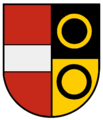
coat of arms
The coat of arms of the municipality of Häg-Ehrsberg combines elements from the coats of arms of the former municipalities of Häg and Ehrsberg. The blazon reads: In a split shield in front in silver on a green three-mountain, a bricked red tin tower, at the back divided by black and gold, above and below each a ring in mixed colors.
The green Dreiberg with the bricked red pinnacle tower was also to be found on the Häger coat of arms, but there was still a red ring. The Zinnenturm stands for the abandoned Altenstein Castle (see also first certificates ). The black and gold rings on the right ("rear") side of the coat of arms also formed the rear part of the Ehrsberg coat of arms in this form; they are based on the family coat of arms of the barons of Schönau. The front part of the earlier Ehrsberg coat of arms showed the coat of arms of front Austria (in red a silver bar).
Coat of arms of the former municipality of Ehrsberg

Coat of arms of the former municipality of Häg
Family coat of arms of those of Schönau

Coat of arms of front Austria


Culture and sights
Site and buildings

In the west of the municipality, Rohmatt is the first district that can be reached from Mambach. At the entrance to the village are the two former textile factories, the grounds of which were taken over by other companies after the decline of the Wiesentäler textile industry. The factories are followed by the actual village, which continues up the country road. To the north and south, the roads branch off to the Wölflisbrunn and Husarenmühle. Following the country road, after a few kilometers you will reach the Zinken Häger Mühle. There the county road 6302 branches off to the north, which first reaches Häg uphill. At the southern entrance to the village are the cemetery and the Catholic parish church of St. Michael. The church was built in 1888 in the neo-Romanesque style. A previous church, built on the same site in 1781, was destroyed by fire. The church comprises three bays , is plastered in white on the outside and has a black gable roof . Behind the church, the place initially extends along the thoroughfare. From around the center of the village, where the school and town hall are located, the street branches out and with it the village. One settlement axis follows the county road uphill in the direction of Ehrsberg, another, smaller one, leads along a local connecting road in an easterly direction to the so-called heap . From there, the connecting road continues downhill, past the Häger waterfalls and into the Angenbachtal, where it joins the country road 146 again.

Middle and ...

... lower part of the Häger waterfalls

Sun mat tines

Happach village


The most populous district of Ehrsberg is located above and north of Häg. In contrast to Häg, which closely follows the road and the slope, Ehrsberg spreads out more on the plain. The center of the village is the St. Wendelin Chapel, built in the late 1840s. From Ehrsberg you reach the Zinken Waldmatt in an easterly direction, where there is a football hard court.
A little below the Häger waterfalls there is a junction to the south from the country road, via which one can reach the Zinken Sonnenmatt and Altenstein, located southeast of Häg. If you instead follow the road past the waterfalls and continue in a north-easterly direction, you will reach Happach on the western slope of the Antoni Pass, the easternmost village of the municipality, which also rises a little up along the road.
Music and culture
The music association was founded in Häg in 1899 ; After the Second World War, it was re-established as Feuerwehrmusik Häg in 1946 and renamed Trachtenkapelle Häg in 1976 . The development in Ehrsberg was similar: The fire brigade music association was founded there in 1927, re-established in 1946 and since 1972 has also operated as a traditional costume band. In 1997 the two brass bands merged to form the Häg-Ehrsberg traditional costume band . The Rohmatt music association, founded in 1949, exists in the Rohmatt district . In addition to these brass bands, there are two choirs, the Catholic church choir and the Eintracht men's choir in Ehrsberg. In 2011 the association “Theater in den Bergen” was founded, which celebrated its premiere in autumn 2011 with the staging of a landscape play in Hinterhag.
Sports
There are two sports clubs in Häg-Ehrsberg, the fishing club and the SV Häg-Ehrsberg with the gymnastics and football departments. A sports field (hard court) is located on the Waldmatt east of Ehrsberg. In the 2011/12 season, the SV men's team plays in a season of the district league B in the Hochrhein district of the South Baden Football Association . In addition to the men's team, there are 3 youth teams. In addition to the actual game operation, SV Häg-Ehrsberg organizes a Grümpel tournament every year, i.e. a football tournament for amateur teams.
Regular events
As in numerous other former Catholic places in Upper Austria, there is also a carnival tradition in Häg-Ehrsberg . The Hinterhager fools guild has several foolish groups , as well as the independent group of the Mühlibach demons Hinterhag . For the annual program of Haeger carnival include a Hemdglunki -Move, a parade on "Fasnachtsmändig" ( Rose Monday ) and a carnival combustion. The "head" of the Häg-Ehrsberger Carnival is the castle bailiff .
Economy and Infrastructure
Land use
Measured against the population, the district of Häg-Ehrsberg is relatively large, which is also shown in the fact that only 126 hectares or 5% of the municipality's area is used for settlement and transport purposes. Forest (1430 hectares or 57.1%) and agricultural land (940 hectares or 37.6%) make up the largest part of the district. 8 hectares are used for water and other uses.
traffic
Southwest of Häg-Ehrsberg, near Mambach, the road 146 branches off from the federal road 317 and leads in a north-easterly direction through the entire municipality to Todtmoos-Mättle, where it crosses the districts of Rohmatt and Happach. A few kilometers northeast of Rohmatt, the county road 6302 branches off in a northerly direction and leads through the district of Häg to Ehrsberg. There are also numerous connecting roads between the individual districts, Zinken and courtyards. The community does not have a connection to rail traffic; Until the closure of the Zell railway in Wiesental-Todtnau (Todtnauerli) , there was still one stop on this line in neighboring Mambach, today the closest train station is in Zell. In Häg-Ehrsberg itself there is a connection to some local and national bus connections of the Regio Verkehrsverbund Lörrach .
Established businesses
With the decline of the Wiesentäler textile industry, the manufacturing industry in Häg-Ehrsberg also lost its importance, so that there is no longer any industrial enterprise in the community and the vast majority of the population no longer works in the community. In 2010, 320 employees subject to social security contributions were registered in the municipality, of which 287 commuted beyond the municipal boundary. Local businesses are mainly craft businesses, of which nine were registered with 32 employees in 1995, the majority of them (18 employees) in the construction and finishing trades. Other branches are retail and hospitality / tourism; In 1995, 21 people were employed in these sectors.
The number of farms fell from 117 in 1979 to 60 in 2007, while the average farm size increased from eight to 15 hectares. Around 90% were part-time businesses. Almost the entire agricultural area is used as permanent grassland for livestock farming, especially for cattle and sheep.
education

In the 19th century there were eight schools in Hinterhag: In Häg, Ehrsberg and Happach there was a secondary school each , so-called secondary schools were in Altenstein, Rohmatt, Rohrberg, Waldmatt and Stadel. In the 1850s a factory school was added in Rohmatt. The secondary schools in Rohmatt and Altenstein were dissolved in 1856 and 1868, later the others too, so that in 1975 only the secondary schools in Häg, Ehrsberg and Happach existed. After the Ehrsberg and Happach schools were dissolved in the following years, the Angenbachtal elementary and secondary school was founded in 1976 , located in the Häg district. Today the Angenbachtalschule is only a primary school, secondary schools are in Zell ( Gerhard-Jung-Schule and Montfort-Realschule ) and Schönau ( Gymnasium Schönau ). The Häg-Ehrsberger Schule has been supported by the Angenbachtalschule Förderverein since 2011 . There is also a Caritas nursery in Häg .
Personalities
The German general Fridolin von Senger and Etterlin (1891–1963) spent his old age in Happach and was buried in the cemetery in Häg after his death.
On August 24, 1965, the Ehrsberg congregation awarded the composer Franz Philipp (1890–1972) honorary citizenship “for the loyalty he has always kept to the home congregation of his ancestors”.
literature
- Hans Fräulin: New history of the city of Zell im Wiesental. Self-published by the city of Zell im Wiesental, Zell im Wiesental 1999, ISBN 3-932738-13-6 .
- Landesarchivdirektion Baden-Württemberg, district Lörrach (ed.): The district Lörrach. Volume I (Aitern to Inzlingen), Jan Thorbecke Verlag, Sigmaringen 1993, ISBN 3-7995-1353-1 , pp. 854-874.
- Ernst Rümmele: The Hinterhag - On the history of the community Häg-Ehrsberg. published by the municipality of Häg-Ehrsberg, Greiserdruck, Rastatt 1977.
Web links
- Official website of the municipality of Häg-Ehrsberg
- Website about the municipality of Häg-Ehrsberg
- Regional information system for Baden-Württemberg (LeoBW): Häg-Ehrsberg - archive material
Remarks
- ↑ State Statistical Office Baden-Württemberg - Population by nationality and gender on December 31, 2018 (CSV file) ( help on this ).
- ↑ All altitude information in this section is in meters above sea level.
- ↑ See also the geological map of the Black Forest from Meyers Konversations-Lexikon on zeno.org
- ↑ State Institute for Environment, Measurements and Nature Conservation Baden-Württemberg: Geotopes in Baden-Württemberg Glossary (PDF; 1.1 MB), p. 12
- ↑ Landkreis Lörrach (ed.): Der Landkreis Lörrach , p. 854f.
- ^ The state of Baden-Württemberg. Official description by district and municipality. Volume VI: Freiburg region Kohlhammer, Stuttgart 1982, ISBN 3-17-007174-2 . Pp. 914-915
- ^ Deutscher Wetterdienst : mean values for the normal period 1961 to 1990
- ↑ Data evaluation sheet NP 6 - Southern Black Forest, accessed on June 16, 2012 from the data and map service ( memento of the original from April 19, 2013 in the Internet Archive ) Info: The archive link was inserted automatically and has not yet been checked. Please check the original and archive link according to the instructions and then remove this notice. the state environmental authority of Baden-Württemberg
- ↑ Data evaluation sheet FFH 8213341 - Weidfelder im Oberen Wiesetal, accessed on June 16, 2012 from the data and map service ( memento of the original from April 19, 2013 in the Internet Archive ) Info: The archive link was inserted automatically and has not yet been checked. Please check the original and archive link according to the instructions and then remove this notice. the state environmental authority of Baden-Württemberg
- ↑ FFH 8313341 - Weidfelder near Gersbach and an der Wehra, accessed on June 16, 2012 from the data and map service ( memento of the original from April 19, 2013 in the Internet Archive ) Info: The archive link was inserted automatically and has not yet been checked. Please check the original and archive link according to the instructions and then remove this notice. the state environmental authority of Baden-Württemberg
- ↑ FFH 8213342 - Gletscherkessel Präg, accessed on June 16, 2012 from the data and map service ( memento of the original from April 19, 2013 in the Internet Archive ) Info: The archive link was inserted automatically and has not yet been checked. Please check the original and archive link according to the instructions and then remove this notice. the state environmental authority of Baden-Württemberg
- ↑ Data evaluation sheet SPA 8114441 - Southern Black Forest, accessed on June 16, 2012 from the data and map service ( Memento of the original from April 19, 2013 in the Internet Archive ) Info: The archive link was automatically inserted and not yet checked. Please check the original and archive link according to the instructions and then remove this notice. the state environmental authority of Baden-Württemberg
- ↑ Data evaluation sheet FND 83361060001 - Waterfall (Häger waterfalls), accessed on June 16, 2012 from the data and map service ( Memento of the original from April 19, 2013 in the Internet Archive ) Info: The archive link was automatically inserted and not yet checked. Please check the original and archive link according to the instructions and then remove this notice. the state environmental authority of Baden-Württemberg
- ↑ Protected area profile 83361060001 waterfall (Häger waterfalls)
- ↑ a b Landkreis Lörrach (ed.): Der Landkreis Lörrach , p. 870ff.
- ↑ Klaus Schubring: Where was Altenstein Castle? . In: Das Markgräflerland , Volume 1/2012, pp. 106–117. For the assignment to the Henschenberg: Andre Gutmann: Under the coat of arms of Fidel. The lords of Wieladingen and the lords of the stone between ministerialism and aristocratic rule With the collaboration of Christopher Schmidberger (research on the history of the Upper Rhine region, vol. 55), Freiburg i. Br./München 2011, p. 320f. ( Full text as PDF ).
- ↑ Fräulin, New History of the City of Zell im Wiesental , p. 33f.
- ↑ Fräulin, Neue Geschichte der Stadt Zell im Wiesental , (p. 33) mentions a pledge from 1393, in which the village of Ehrsberg was pledged in addition to Altenstein Castle
- ↑ Landkreis Lörrach (ed.): Der Landkreis Lörrach , p. 871
- ↑ Rümmele, Der Hinterhag , p. 27
- ↑ see e.g. B. the website of the municipality, hinterhag.de
- ↑ The Hinterhag in the beautiful Angenbachtal on hinterhag.de
- ↑ Fräulin, New History of the City of Zell im Wiesental , p. 139
- ↑ Rümmele, Der Hinterhag , p. 102
- ↑ Rümmele, Der Hinterhag , p. 136ff.
- ↑ Rümmele, Der Hinterhag , pp. 138ff.
- ↑ Fräulin, New History of the City of Zell im Wiesental , p. 72f.
- ↑ Rümmele, Der Hinterhag , p. 107f.
- ↑ Rümmele, Der Hinterhag , pp. 174–181
- ↑ Rümmele, Der Hinterhag , p. 108
- ↑ Rümmele, Der Hinterhag , p. 189
- ↑ Rümmele, Der Hinterhag , p. 184
- ↑ Rümmele, Der Hinterhag , pp. 182-189
- ↑ Landkreis Lörrach (ed.): Der Landkreis Lörrach , p. 860f.
- ↑ Rümmele, Der Hinterhag , p. 213
- ↑ Rümmele, Der Hinterhag , pp. 111–115
- ↑ Rümmele, Der Hinterhag , p. 144
- ↑ Rümmele, Der Hinterhag , p. 119, p. 122
- ↑ Rümmele, Der Hinterhag , p. 129ff.
- ↑ Lörrach district, p. 865
- ^ Federal Statistical Office (ed.): Historical municipality directory for the Federal Republic of Germany. Name, border and key number changes in municipalities, counties and administrative districts from May 27, 1970 to December 31, 1982 . W. Kohlhammer, Stuttgart / Mainz 1983, ISBN 3-17-003263-1 , p. 522 .
- ↑ Lörrach district, p. 866
- ↑ Badische Zeitung, June 1, 2011: In the anniversary year one looks ahead
- ↑ a b c d e State Statistical Office of Baden-Württemberg: Structural and regional database
- ↑ Landkreis Lörrach (Ed.): Der Landkreis Lörrach , p. 861
- ↑ a b Landkreis Lörrach (ed.): Der Landkreis Lörrach , p. 868
- ↑ Pastoral care unit in Zell im Wiesental ( Memento of the original from December 10, 2008 in the Internet Archive ) Info: The archive link was inserted automatically and has not yet been checked. Please check the original and archive link according to the instructions and then remove this notice.
- ↑ Website of the municipality: hinterhag.de
- ↑ Preliminary results of the 2019 municipal council elections at the State Statistical Office
- ↑ Landkreis Lörrach (Ed.): Der Landkreis Lörrach , p. 862
- ↑ Landkreis Lörrach (ed.): Der Landkreis Lörrach , p. 854
- ↑ Lörrach district, p. 858f.
- ↑ Lörrach district, p. 895
- ↑ Chronicle. the traditional costume band Häg-Ehrsberg
- ↑ Internet presence of the municipality of Häg-Ehrsberg: Associations
- ↑ Theater in the Mountains. In: Badische Zeitung. May 14, 2011.
- ^ SV Häg-Ehrsberg: Association ( page no longer available , search in web archives ) Info: The link was automatically marked as defective. Please check the link according to the instructions and then remove this notice.
- ↑ Internet presence of the Hinterhager fools guild: HNZ
- ↑ Landkreis Lörrach (Ed.): Der Landkreis Lörrach , p. 868
- ^ Badische Zeitung, March 26, 2011: Foundation of the friends' association
- ↑ Rümmele, Der Hinterhag , p. 164

Aitern | Bad Bellingen | Binzen | Böllen | Efringen churches | Eimeldingen | Fischingen | Happy | Grenzach-Wyhlen | Häg-Ehrsberg | Hazel | Hausen im Wiesental | Inzlingen | Kandern | Small meadow valley | Loerrach | Malsburg-Marzell | Maulburg | Rheinfelden | Rümmingen | Schallbach | Schliengen | Schönau in the Black Forest | Schönenberg | Schopfheim | Schwörstadt | Stones | Todtnau | Tunau | Utzenfeld | Because on the Rhine | Wembach | Wieden | Whiting | Zell im Wiesental