
Utzenfeld
| coat of arms | Germany map | |
|---|---|---|

|
Coordinates: 47 ° 48 ' N , 7 ° 55' E |
|
| Basic data | ||
| State : | Baden-Württemberg | |
| Administrative region : | Freiburg | |
| County : | Loerrach | |
| Local government association: | Schönau in the Black Forest | |
| Height : | 561 m above sea level NHN | |
| Area : | 7.4 km 2 | |
| Residents: | 622 (December 31, 2018) | |
| Population density : | 84 inhabitants per km 2 | |
| Postal code : | 79694 | |
| Area code : | 07673 | |
| License plate : | LÖ | |
| Community key : | 08 3 36 090 | |
| LOCODE : | DE UZF | |
| Address of the municipal administration: |
Wiesentalstrasse 29 79694 Utzenfeld |
|
| Website : | ||
| Mayor : | Harald Lais | |
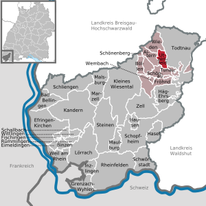
| Location of the municipality of Utzenfeld in the district of Lörrach | ||
  |
||

Utzenfeld ( Alemannisch Utzefäld ) is a municipality in the Black Forest in Baden-Württemberg .
geography
The municipality of Utzenfeld is 560 to 1124 meters above sea level in the upper Wiesental in the Southern Black Forest Nature Park . The core town extends along the right bank of the meadow between the cities of Schönau in the Black Forest and Todtnau .
Neighboring communities
The community borders in the north on Wieden , in the east on the city of Todtnau, in the south on Tunau and the city of Schönau in the Black Forest and in the west on Aitern .
Community structure
The community Utzenfeld includes the village of Utzenfeld and the Zinken Königshütte, which partly extends over the Wiedener area. In addition, the Knöpflesbrunnen residential area belongs to Utzenfeld.
history
Utzenfeld was first mentioned in a document in 1294. The place belonged to the monastery of St. Blasien and thus from 1368 to Upper Austria . When the monastery was secularized in 1806, the village became part of the newly created Grand Duchy of Baden . In 1809 Utzenfeld became an independent municipality.
As early as the High Middle Ages there was silver-lead mining in Utzenfeld, but to a lesser extent compared to mining in Wieden and Schönau. There was an ore mill in Utzenfeld. From 1922 to 1972 fluorspar and barite were mined in Utzenfeld . The administration and processing building built in 1942/43 also served the Finstergrund mine in neighboring Wieden. Russian forced laborers were also used in the construction of the large wing in 1942/43. From 1980 a riding stables were operated in the building.
politics

Utzenfeld has been a member of the Schönau community administration association in the Black Forest since 1971 .
Municipal council
The municipal council in Utzenfeld has eight members. It consists of the elected honorary councilors and the mayor as chairman. The mayor is entitled to vote in the municipal council. The local elections on May 29, 2019 led to the following preliminary final result. The turnout was 66.1% (2014: 57.7%).
| Political party | be right | Seats |
| Free voters | 79.7% | 6th |
| Citizen-friendly list | 20.3% | 2 |
coat of arms
A pair of silver pliers and a golden palm branch crossed diagonally in blue. The symbols in the coat of arms are reminiscent of the martyrdom of St. Apollonia of Alexandria , to whom the village chapel is dedicated. The coat of arms has been used since 1902. Before that, the church had only used seals.
Religions

Due to the fact that it belongs to Upper Austria, the Reformation passed Utzenfeld by, so that even today the majority of the population is Roman Catholic. The place belongs to the Roman Catholic parish Schönau in the Black Forest, but there is its own church in Utzenfeld. The few Protestant residents are also parish in Schönau.
Natural monuments
The Utzenfluh nature reserve has existed since 1940 with many natural sights, some of which are also located in the district of Todtnau.
Economy and Infrastructure
Transport
From 1889 to 1966 Utzenfeld was connected to the rail network by the Zell im Wiesental – Todtnau railway line. Today the place is connected to the local public transport by the regional bus route 7300 (Basel-Titisee) of the SBG Südbadenbus GmbH . The Wiesentalstrasse ran through Utzenfeld until 1982/83 from Basel over the Feldberg, which was then relocated from the town center to the left bank of the meadow. The two pass roads (L 123 and L 142) begin to the south and north of Utzenfeld, leading to the Wiedener Eck and making the transition to the Upper Rhine Valley via Münstertal . The valley station of the Belchen cable car can also be reached via Aitern via the L 142 .
Established businesses
Utzenfeld is the site of a major chemical producers (a subsidiary of Celanese -Konzerns) of the major polyamide - compounders belongs in Europe. The Faller jam manufacturer is well known. There are also two construction companies based in Utzenfeld, Walliser Bau GmbH & Co KG and Steinebrunner Holzbau.
Education
There is no school in Utzenfeld, elementary school students attend the joint elementary school Wieden-Utzenfeld in Wieden. The pupils from the fifth grade attend the secondary school in Schönau in the Black Forest, the secondary school in Zell in the Wiesental or the high school in Schönau in the Black Forest. For the youngest residents there is the “Utzenfluh” kindergarten .
literature
- Utzenfeld. In: Department State Description of the State Archives Freiburg im Breisgau (editor): District descriptions of the State of Baden-Württemberg. The district of Loerrach. Volume II. B. Community descriptions Kandern to Zell im Wiesental. Published by the Baden-Württemberg State Archives Directorate in conjunction with the Lörrach district. Jan Thorbecke Verlag, Sigmaringen 1994, ISBN 3-7995-1354-X . Pp. 730-741.
- Albrecht Schlageter : On the history of the village of Utzenfeld. In: The Markgräflerland. Issue 1/1995, pp. 5-56 ( digitized version of the Freiburg University Library ).
Web links
- Regional information system for Baden-Württemberg (LeoBW): Utzenfeld - archive material
- Regional information system for Baden-Württemberg (LeoBW): Utzenfeld - Altgemeinde ~ sub-town - Historical local dictionary Baden-Württemberg
Individual evidence
- ↑ State Statistical Office Baden-Württemberg - Population by nationality and gender on December 31, 2018 (CSV file) ( help on this ).
- ^ Regional information system for Baden-Württemberg (LeoBW): Königshütte - Wohnplatz - Historical Ortlexikon Baden-Württemberg
- ^ The state of Baden-Württemberg. Official description by district and municipality. Volume VI: Freiburg region Kohlhammer, Stuttgart 1982, ISBN 3-17-007174-2 . P. 880.
- ^ Regional information system for Baden-Württemberg (LeoBW): Knöpflesbrunnen - living space - historical local dictionary of Baden-Württemberg
- ↑ Hansjörg Noe: How important was the Finstergrund mine for the National Socialists? in: Badische Zeitung of February 10, 2020; accessed on February 11, 2020
- ↑ Harald Huber: Wappenbuch Landkreis Lörrach. In Verlag des Südkurier, Konstanz 1984, p. 128.
- ↑ US group takes over Nilit Plastics. In: Markgräfler Tagblatt. May 5, 2017 ( verlagshaus-jaumann.de ).
- ↑ Celanese homepage , accessed February 10, 2020.
- ↑ Homepage of the Alfred Faller GmbH jam manufacturer , accessed on February 10, 2020.
- ↑ Homepage of the Vogel-Walliser group of companies , accessed on February 10, 2020.

Aitern | Bad Bellingen | Binzen | Böllen | Efringen churches | Eimeldingen | Fischingen | Happy | Grenzach-Wyhlen | Häg-Ehrsberg | Hazel | Hausen im Wiesental | Inzlingen | Kandern | Small meadow valley | Loerrach | Malsburg-Marzell | Maulburg | Rheinfelden | Rümmingen | Schallbach | Schliengen | Schönau in the Black Forest | Schönenberg | Schopfheim | Schwörstadt | Stones | Todtnau | Tunau | Utzenfeld | Because on the Rhine | Wembach | Wieden | Whiting | Zell im Wiesental