Wieden (Black Forest)
| coat of arms | Germany map | |
|---|---|---|

|
Coordinates: 47 ° 50 ' N , 7 ° 53' E |
|
| Basic data | ||
| State : | Baden-Württemberg | |
| Administrative region : | Freiburg | |
| County : | Loerrach | |
| Local government association: | Schönau in the Black Forest | |
| Height : | 828 m above sea level NHN | |
| Area : | 12.25 km 2 | |
| Residents: | 541 (December 31, 2018) | |
| Population density : | 44 inhabitants per km 2 | |
| Postal code : | 79695 | |
| Area code : | 07673 | |
| License plate : | LÖ | |
| Community key : | 08 3 36 096 | |
| Address of the municipal administration: |
Kirchstrasse 2 79695 Wieden |
|
| Website : | ||
| Mayoress : | Annette Franz | |
| Location of the municipality of Wieden in the district of Lörrach | ||
Wieden is a municipality in Baden-Württemberg and belongs to the district of Lörrach .
geography

Wieden in the Black Forest with the parish church of All Saints
|
Geographical location
The state-approved resort of Wieden is located in a high valley between Schauinsland ( 1283.9 m ), Feldberg ( 1493 m ) and Belchen ( 1414.2 m ) in the Southern Black Forest Nature Park at an altitude of 740 to 1280 meters.
Neighboring communities
The community borders in the northeast and east on the town of Todtnau , in the south on Utzenfeld , in the west on Aitern and in the northwest on Münstertal / Black Forest in the district of Breisgau-Hochschwarzwald .
Community structure
The municipality of Wieden includes the village of Oberwieden, the hamlets of Hüttbach, Lailehäuser, Laitenbach, Neßlerhäuser, Säge and Warbach, the Zinken Bühl, Graben, Rütte and Ungendwieden, the farms Mittelbach, Neumatt and Schwaine and the houses Beckenrain, Eckle (Sommereckle) and Königshütte , which partly extends to the Utzenfeld area, Niedermatt, Scheuermatt, Steinen, Wiedener Eck and Wiedenmatt.
history
Wieden has been an independent municipality since 1809.
politics
Administrative association
The community belongs to the community administration association Schönau in the Black Forest .
Mayoress
Mayor is Annette Franz.
Municipal council
The municipal council of Wieden consists of eight members. The local elections on May 26, 2019 led to the following result:
| Free voters | 51.8% | 4 seats | (2014: 54.9%, 4 seats) |
| CDU | 48.2% | 4 seats | (2014: 45.1%, 4 seats) |
coat of arms
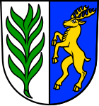
The coat of arms of the municipality of Wieden shows a green willow branch pointing to the place name on a silver background. The leaping deer in gold on a blue background is the heraldic animal of the St. Blasien monastery and reminds of the centuries-long affiliation of the place to the Schönau valley bailiwick.
Attractions
- Finstergrund visitor mine
Economy and Infrastructure
education
In Wieden there is the joint primary school Wieden-Utzenfeld, which is attended by students from Wieden and Utzenfeld. The pupils from the fifth grade attend the secondary school in Schönau in the Black Forest, the secondary school in Zell in the Wiesental or the high school in Schönau in the Black Forest.
Emergency services
- Wieden Volunteer Fire Brigade
- Black Forest Mountain Rescue Service , Wieden local group
Personalities
Honorary citizen
- Xaver Schwäbl (Former Rector of the Wieden-Utzenfeld Elementary School)
Sons and daughters of the church
- Markus Wunderle (* 1968), tug of war
Other personalities connected to the community
- Melanie Behringer (* 1985), national soccer player
Individual evidence
- ↑ State Statistical Office Baden-Württemberg - Population by nationality and gender on December 31, 2018 (CSV file) ( help on this ).
- ^ Landesarchivdirektion Baden-Württemberg (ed.): Das Land Baden-Württemberg. Official description by district and municipality. Volume 6: Freiburg administrative region. Kohlhammer, Stuttgart 1982, ISBN 3-17-007174-2 , p. 881.
- ↑ Preliminary results of the 2019 municipal council elections at the State Statistical Office


