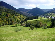
Präg glacier basin
|
Nature reserve Gletscherkessel Präg
|
||
|
View from Weißenbachsattel (1079 m) to the valley basin, the upper Prägbach valley (middle) and down the valley (left) |
||
| location | Southeast of Todtnau , Baden-Württemberg , Germany | |
| surface | 28.67 km² | |
| Identifier | 3,201 | |
| WDPA ID | 102240 | |
| Geographical location | 47 ° 47 ' N , 7 ° 58' E | |
|
|
||
| Setup date | 1994 | |

The Präg glacier basin is a steep-walled basin in the course of the Prägbach valley in the Black Forest . It belongs to the district of Lörrach in Baden-Württemberg and is a nature reserve .
Natural characteristics
In the village of Präg, which belongs to the town of Todtnau, the Prägbachtal bends sharply by around 100 ° to the right (northwest), with the stream flowing around the elbow , a central elevation, on three sides in a narrow notch. The many short side valleys that flow into this area together form the basin. The already pronounced Ice Age treasure trove of the Prägbach valley with a U-shaped cross-section and clear valley steps with waterfalls has its climax here. Crowds of round bumps and numerous, partly steep moraine walls with flank channels that once accompanied the glacier divide the basin, the steep slopes of which are largely covered by block heaps . The village of Präg is located on a Kames terrace. Three small lakes (Präger lakes) and numerous large erratic boulders are further witnesses of the glaciation.
The last time during the Würm glacial period (115,000 to 10,000 years ago), six glaciers collided here - unique for German low mountain ranges . In the high glacial, the ice reached a thickness of more than 500 meters in places, the maximum value for the Black Forest during the Würm Age. One reason for this ice thickness was the inhibition of the glacier runoff by the glacier in the Wiesental , which began in the area of the plateau-like Feldberg glacier . Today's valley floor is 600 to 700 m above sea level. NHN , the heights surrounding the valley basin up to 1309 m above sea level. NHN ( Blößling , Hochkopf ).
The valleys carved out by the glaciers converge in a star shape:
- Valley of the Prägbach from the northeast
- Valley of the Schweinbächles from the east-northeast
- The valley of the Hinter-Wildbodenbach from the east-south-east
- Valley of the Vorder-Wildbodenbach from the south
- Valley of the White stream coming from the south-southwest
- Valley of the Eulenbächles from the west-southwest
Flora and fauna
The area around the glacier basin has an interesting flora and fauna. On the extensively managed pastures you can find rare and endangered species such as arnica and various orchids (including the spotted orchid ). Almost all of Baden-Württemberg's mosses and ferns to be protected are on the FFH list; Particularly noteworthy is Roger's golden hair moss ( Orthotrichum rogeri ), which has its European focus here.
The rare zippammer occurs here as well as the capercaillie , the barn owl and the black woodpecker . Insects found in the area include the quail wheat butterfly and the wart-bite .
natural reserve
The nature reserve designated on June 27, 1994 by the Freiburg regional council on the boundaries of Todtnau, Tunau and Schönau with the Präger glacier basin in the center is, with an area of 2867 hectares, the second largest nature reserve in Baden-Württemberg after the Feldberg area and part of the FFH area Gletscherkessel Präg and pasture fields in the Upper Wiesental .
Many animals and plants live in semi-open landscapes, which, however, are becoming increasingly bushy as a result of the decline in pasture management. Therefore, from the nature conservation management in collaboration with the grazing and landscape maintenance Zweckverband southern Black Forest and the local clubs Entkusselungen - in the Black Forest Enthurstungen called - performed.
literature
- René Hantke : Ice Age. The recent geological history of the Alps and their neighboring areas , 1992, ISBN 3-609-65300-0
Individual evidence
- ↑ Stefan Kostrzewa: Scale-differentiating effects of large-scale grazing on the biodiversity of the southern Black Forest, point 2.3 Climate, geology, geomorphology, soil (dissertation) (PDF; 11.4 MB)
- ↑ Nature reserve Gletscherkessel Präg - Hiking & Meadows ??. Accessed December 3, 2019 (German).
- ↑ Natura 2000 Management Plan (MaP) Gletscherkessel Präg / Weidfelder in the Upper Wiesental
Web links
- Profile of the nature reserve in the LUBW's list of protected areas
- Präger Gletscherkessel on nsgp.de
- Overview map (PDF file, 3.3 MB)


