
Prägbach
| Prägbach | ||
 The middle Prägbach, rich in cataracts |
||
| Data | ||
| Water code | EN : 2322 | |
| location |
Black Forest
|
|
| River system | Rhine | |
| Drain over | Meadow → Rhine → North Sea | |
| source | Southwest slope of Grafenmatt 47 ° 50 ′ 39 ″ N , 8 ° 1 ′ 1 ″ E |
|
| Source height | approx. 1325 m above sea level NHN | |
| muzzle | at Geschwend coordinates: 47 ° 48 '18 " N , 7 ° 55' 59" E 47 ° 48 '18 " N , 7 ° 55' 59" E |
|
| Mouth height | 570 m above sea level NHN | |
| Height difference | approx. 755 m | |
| Bottom slope | approx. 51 ‰ | |
| length | 14.7 km | |
| Catchment area | 30.76 km² | |
| Discharge at the mouth of the A Eo : 30.76 km² |
MNQ MQ Mq MHQ HHQ |
160 l / s 1.31 m³ / s 42.6 l / (s km²) 22.15 m³ / s 95 m³ / s |
| Left tributaries | Wildbodenbächle, Weißenbach | |
| Right tributaries | Gisibodenbach | |
| Reservoirs flowed through | Wacht power station pond | |
| Communities | Coined, Geschwend | |
The Prägbach is the largest left tributary of the southern Black Forest river Wiese and is located in southwest Baden-Württemberg . Its deep valley, subdivided by steep steps, was shaped in a special way by glaciers from the last glacial periods .
geography
Course and valley landscape
The source area of the Prägbach lies in a high area characterized by soft relief forms between the Feldbergpass ( 1077 m above sea level ) in the north and the Herzogenhorn ( 1415.6 m above sea level ) in the south. The stream now flows between the Herzogenhorn and the Silberberg ( 1,358.9 m above sea level ) generally southwest through a meadow valley interspersed with small moors. The bottom of the narrow high valley, which is 1200 meters high, runs like a dam between the neighboring valleys of the Bernauer Alb in the southeast and the meadow in the northwest, which are cut 300 to 400 meters deeper .
In the following first valley step, which leads down to the approximately 950 meters high and basin-shaped sunk Präger floors , the uppermost, approximately 6 meter high waterfall of the Prägbach has formed near the Bernauer Kreuz saddle . This valley step , almost 150 meters high, is typical of mountain valleys that are heavily shaped by glaciers. At the lower end of the Präger Boden, the stream has been dammed in a small pond (approx. 0.25 ha) since 1922 and largely diverted for the small Wacht hydropower station at the foot of the following valley step . From here, the Prägbach is accompanied by the L 149 country road, which leads from Bernau over the deeply cut transfluence pass Wacht into the Wiesental.
This is followed by a Kerbtal stretch in which there are cataracts up to 3 meters high and a waterfall about 6 meters high. The valley gradually becomes trough-shaped and shows droves of rounded humps in the valley meadows , while the stream flowing in a small notch is hidden from view.

With the entry into the Präger boiler of Bach brings south to the gorge-like Talschlinge elbow , which he places a small mountain in the middle of the boiler. After its abrupt bend to the right, the stream leaves the basin to the northwest, where another rocky cliff visually delimits the basin.
Six Ice Age glaciers flowing together here cleared the Präger Kessel in an area with slightly less resistant rocks. Here in the north-east trending Kulm strip of Badenweiler-Lenzkirch, slate and greywacke from the Upper Devonian and Lower Carbons , volcanic rocks , tuff and sandstones are exposed , whereas the surrounding area is made up more of various types of granites and gneisses . The bottom of the Präger Kessel is slightly lower than the bottom of most of the neighboring valleys. Due to the only slight incline to the Wiesental valley, which was also highly ice-filled during the cold periods, the largest glacier in the Black Forest, around 500 meters thick, was able to accumulate and accumulate here. In the south of the valley basin, the village of Präg lies on a chimney terrace . It is flanked by the most important southern tributaries, the Wildbodenbächle and the Weißenbach.
At a last valley step almost buried under valley sediments, the valley widens again and gives space to the village of Geschwend on the north side . The largest side stream, the Gisibodenbach, descends from a cultivated high alpine pasture, flows here from the right. A little below the Prägbach flows with an average water flow of 1.31 m³ / s into the little larger meadow (1.76 m³ / s). In length, the Prägbach exceeds the previous course of the meadow by a good 3 kilometers.
Tributaries
From the headwaters to the estuary: length of the river, catchment area and altitude according to the corresponding layers on the LUBW online map
The headwaters of the Prägbach are at around 1325 m above sea level. NHN on the southwest slope of the Grafenmatt ( 1376.5 m above sea level , in the north of the Herzogenhorn ). Up to the first tributary, this uppermost source brook has a length of 6.4 km and a catchment area of 5.67 km²
- Kesselbach, from the right and north to about 844 m above sea level. NHN west of the saddle Wacht :
1.08 km; approx. 0.7 km². Headwaters at about 1090 m above sea level. NHN on the southeast slope of the Brenntkopf ( 1245 m above sea level ) - Wildbodenbächle, from the left and southeast to about 789 m above sea level. Above sea level in the deeply notched elbow :
2.3 km; approx. 4.2 km². Headwaters at about 1070 m above sea level. NHN on the northeast slope of the Hochkopf ( 1263 m above sea level ). The brook arises from the Hinter- and the Vorder-Wildbodenbächle. - Weißenbach, from the left and southwest to about 867 m above sea level. NHN in the southwest of the Elbow north of Präg :
2.9 km; approx. 4.3 km². Headwaters at about 1065 m above sea level. NHN at the Weißenbachsattel ( 1077 m above sea level ) - Schwarzenbach, from the left and west to about 635 m above sea level. NHN at the exit of the Präger Kessel :
1.5 km; 1.4 km². Headwaters north of the Nollenkopf at about 1050 m above sea level. NHN - Gisibodenbächle, from the right and northeast to about 593.5 m above sea level. NHN in the east of Geschwend:
4.0 km; 5.3 km². Headwaters at about 1165 m above sea level. NHN on the Hochalm Gisiboden .
At the mouth (from the left) into the meadow at about 570.1 m above sea level. NHN west of Geschwend the course of the Prägbach ends after 14.7 kilometers.
- Steep steps in the valley of the Prägbach

The top waterfall at the Bernauer Kreuz (6 m)
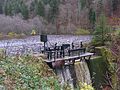
The small reservoir of the Wacht hydropower plant

Waterfall at the middle Prägbach (6 m)

The upper cascades of the Hinter-Wildbodenbächle


Individual evidence
- ↑ a b c d State Institute for the Environment Baden-Württemberg (LUBW) ( notes ), height according to the contour line image on the background layer topographic map
- ↑ a b State Institute for the Environment Baden-Württemberg (LUBW) ( notes ), length according to the water network layer ( AWGN )
- ↑ a b c d e Geoportal Baden-Württemberg: LUBW Service Flowing Waters - discharge parameters , accessed on May 11, 2020
- ↑ District Office for Nature Conservation and Landscape Management Freiburg: Expert opinion on the planned nature reserve Gletscherkessel Präg
literature
- Geographisch-Kartographisches Institut Meyer [Hrsg.]: Meyers Naturführer - Südschwarzwald Mannheim, 1989 ISBN 3-411-02775-4 .
- M. Pfannenstiel, G. Rahm: The Würmzeitlichen glaciers of the valley basin of Präg , Ber. Naturf. Ges. Freiburg i.Br, Vol. 51, pp. 119–132, Freiburg 1961 (accessed on May 15, 2020)