Terrace (geology)
A terrace (from French terrace ) is a flat to slightly sloping part of the terrain, which is separated from neighboring parts of the terrain by an embankment or a steeper slope.
In geology and geomorphology , the term is used for flat rock or gravel steps on valley slopes . Terraces indicate the location of the original river bed (see river terrace), the lakeshore (bank terrace) or the beach (beach terrace, surf platform ). Together with the slope, the leveling area forms the boundary of the terrace body. Narrow terraces are often referred to as benches . As erosion progresses , terraces can emerge as isolated remnants with demolition edges on all sides.
The terraces are structured according to genetic criteria
River terrace
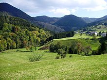
River terraces are elongated flat areas that morphologically subdivide the slopes of river valleys on both sides and at the same height or on one side. River terraces are created by the flowing activity of water: River terraces can arise as forms of accumulation (embankment terrace) as well as forms of erosion (rock bed terrace). The relatively flat terrace areas are laterally limited by steeper slopes. The transition between the level terrace area and the steeper slope is called the terrace edge.
The formation of river terraces is often the result of climatic fluctuations or tectonic movements . While erosive processes determine the development of valleys in warm periods due to the higher surface discharge, in cold periods the deposition of sediments and the gravel of terraces dominate due to the decrease in water flow . The repeated alternation of cold and warm periods can create characteristic terrace steps or terrace stairs on valley slopes. The thickness of the terrace deposits and their altitude are controlled by a variety of climatic, tectonic and sedimentological factors.
The two basic types of river terraces - rock bed terrace and embankment terrace - arise from sedimentation or erosion of rock material.
Crag terrace
Rock terraces or rock bottom terraces are remnants of old valley floors that have formed in the rock . Most of these terraces no longer have gravel bodies, only a thin veil of gravel may have been preserved. The formation of rock bottom terraces can be divided into several phases:
- The uplift of the surrounding area increases the depth of erosion and the river deepens. The former valley floor will be largely reconditioned.
- If the uplift tendency decreases, the side erosion of the river increases and the valley floor widens.
- When the surrounding area starts to rise again, the river cuts itself again and the valley floor that has formed is eroded again. The remains of erosion then form a new level of rock bottom terraces.
This cycle can be repeated several times in the course of the earth's history and lead to the development of a rock-bottom terrace staircase.
Landfill terrace
Embankment terraces are created by the deposition of fluvial sediments with subsequent deep erosion. In contrast to the rock-bottom terraces, embankment terraces have a more or less powerful gravel body. Conclusions about the deposition conditions can be drawn from the different petrographic , sedimentological and mineralogical properties of the deposits that make up the gravel body. The qualitative and quantitative petrological composition of the terrace body allows statements about the delivery area of the rocks. Together with the grain size distribution, the sorting, the heavy mineral spectrum, the degree of rounding and the degree of weathering , the deposition conditions (climate, transport distance, runoff behavior and delivery area) can be reconstructed. The stratification and regulation of the rocks allows conclusions to be drawn about the flow regime of a river and thus indirectly about the climatic conditions. The direction of flow can be determined by adjusting the mostly flattened, rounded rocks. Structures can sometimes be found in the ballast that have not been filled with ballast but with other material. Most of these structures are so-called ice wedges that were created in the periglacial area . After the wedges had defrosted, the resulting cavities were filled with material from the hanging wall. Occasionally older terraces are covered with loess .
Lakeside terrace
A lake terrace represents a former coastline on the shore of a glacial or non-glacial lake . Terrace-shaped planarization on the edge of a lake is caused by the accumulation of shallow water sediments in the bank area or by erosion due to water movements. Compared to sea terraces, the lake terraces are much narrower due to the lower wave movements. Some lake terraces, which have formed in the glacial environment of ice reservoirs and glacial lakes , do not represent former shorelines, but fossil lake floors.
Sinter terrace
Sinter terraces or sinter cascades often form on projections and steps overflowing with calcareous mineral or thermal water . Preferably in the immediate and wider area of source outflows of such water, pressure reduction and an escape of carbon dioxide from the mineral-containing water occur. Calcium carbonate settles as sintered lime around organic or inorganic crystallization nuclei , usually with the participation of algae . The accumulation of the carbonate-containing substance counteracts the erosive activity of the water and can gradually build up sintered terraces.
The most famous sinter terraces - the Pamukkale sinter basins - are now a UNESCO World Heritage Site . The Plitvice Lakes are also separated from each other by sinter steps up to 20 m high. In addition to numerous well-known terrace formations on the surface, there are sinter basins and terraces, also in karst caves .
Coastal or sea terrace, beach terrace


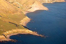
A coastal terrace or sea terrace is created in the immediate area of the shore of the sea due to eustatic sea level fluctuations or land elevations, usually triggered by tectonic processes such as earthquakes. The leveled areas, which are slightly inclined towards the sea, often represent fossil shore and beach areas. Currently, these terrace areas are not in the area of influence of the wave movements. In addition to terrace areas that are located above the current shoreline, terraces can also be formed below today's sea level, which were flooded when the sea level rose. Coastal and sea terraces can be created both by the accumulation of beach sediments (beach terrace) and by erosion as a result of wave movements. While coastal terraces tend to take a long time to accumulate, erosion can be a very short-term event. Rock breaks during storm surges and tsunamis can change and destroy the leveling areas within a very short time.
Depending on the former tidal range, sea terraces are several tens of meters to one kilometer wide and usually have an incline of 1 to 5 °. They can sometimes be spread over several kilometers along the coast. The slope and height of the slope bordering the terraces usually depends on the rock structure, the height of the wave-affected zone and the speed of the sea level fluctuation. A surf cave is often formed at the transition between the terraces and the steep slope that adjoins the rear . The morphology of the older terraces can be changed above the sea line by soil material and subsequent embankments , below the water level by the movement of the waves.
A beach terrace usually consists of rounded gravel and sand that is deposited between the high water level and the low water level. The mostly unconsolidated sand-gravel bodies can be eroded again during storm surge events. Beach terraces made of reef material or solidified beach rocks are much more resistant to erosion . Loose rock material - sometimes also anthropogenic objects, such as beverage cans or bottles - are cemented in tropical and subtropical areas with a calcareous binding agent and form the flat surfaces that accompany the coastline.
Terracing under glacial influence
Solifluction terrace or floating earth terrace

A Solifluktionsterrasse is a flat accumulation shape formed by material displacement due to floor tiles in Auftaubereich of water-saturated permafrost has emerged. The loose rock material is transported down the slope by slow flow movements, often mixing with organic material in the lower slope area. The flow processes can be initiated even on small slopes from 2 °.
Chimney terrace

Kamester terraces are deposited from fluvioglacial ice rim sediments from glacier rivers that flow between the glacier rim and the valley slope. After the glacier has thawed, the sediment body remains as a terrace body. The glacier rivers are often branched out and characterized by a permanent change in direction and speed of flow, so that the terrace body is characterized by a frequent change in the deposited sediments. The grain size spectrum ranges from clay to large blocks . At the edge of the valley, fluvioglacial sediments of the river often mix with the material of the lateral moraine , so that the terrace bodies of the Kamester terraces are very heterogeneous and characterized by chaotic stratification . Most of the time, the elongated Kamester terraces - in contrast to most lateral moraines - can only be observed on one side of the valley.
Nivation terrace
Nivation terraces are planarization areas that are formed by the erosion of perennial and temporary snow fields . In places where snow fields accumulate in hollow forms over a longer period of time, material shifts occur due to the strong moisture penetration, caused by freeze-thaw cycles, freeze bursts, gravitational mass movements and gelifluction . As a rule, more snow is absorbed in the hollow molds than in the surrounding area, which increases the effect. Leveling niches are created which can be further formed by continued gelifluction. The leveling areas in such leveling niches are called Nivation terraces. In the course of further development, these can combine to form cryoplanation terrace levels on the slope.
Cryoplanation terrace
Cryoplanation terraces , also known as altiplanation terraces or Golez terraces , are preferably created in the periglacial climate. Since they are mostly associated with permafrost soils , they are often viewed in the literature as an indicator of fossil and recent permafrost soils. This stepped terrace shape is created by shifting material on slopes due to frost-thaw alternation , in connection with frost blasting , accumulation in snow banks and solifluction .
Cryoplanation terraces are preferred in continental periglacial areas with moderate aridity, mostly on upper slopes. They are often covered by a thin layer of solifluction rubble so that frost pattern soils can develop here . The cryplanation terraces can usually be followed on all sides with a few interruptions. Usually there are several superimposed terraces on a slope. The height of the terraces depends on the nature of the rock and the slope; hard rocks form higher terraces.
Anthropogenic terraces

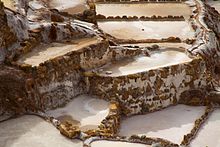
Terraces have been created for thousands of years by human activity in areas with strong morphological relief, in order to gain the flatest possible areas for agriculture and to enlarge and effectively irrigate the workable areas . In addition, terraces fulfill different tasks. In areas at risk of slipping, the slope stability is significantly improved by terracing . Terrace surfaces can divide quarry walls into technically degradable floors and enable the creation of transport routes. Sloping terraces have been used as settlement areas or created to gain settlement areas since the beginning of human development. Many historical examples, such as the ancient Greek city of Pergamon or Andean settlement Machu Picchu are known.
Arable terrace
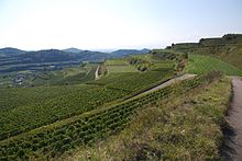
Agriculture has been practiced on fertile terraced areas with loess cover since the Neolithic . Since at least the Bronze Age humans have terraced areas for arable farming. Basically, earth terraces and stone terraces are differentiated. In addition to creating a level work surface, earth terraces have the task of reducing surface runoff and thus better supplying the soil with water. In addition, in dry climates, a flat wall is created on the edge of the terrace on the valley side, which holds back rain and drainage water. As a rule, only special crops, such as wine or certain types of fruit, are grown on stone terraces. Examples of man-made slopes are vineyard terraces, terraces for tea and rice cultivation. In the Andes , maize, peanuts , quinoa , potatoes and cotton are mainly cultivated on terraced slopes .
Mining terraces: berms and benches
As berms artificial terraces are called, which are applied to a bank to stabilize and against landslides secure. By dividing a slope into several sections, the earth pressure on the foot of the slope should generally be reduced. Berms are created both in open-cast mines and when constructing stable dump slopes. The height of the berms and the angle of slope depend primarily on the properties of the rock, in the case of loose rock, in particular, on the grain size distribution and the water saturation . In general, it should be noted that the more water-saturated and sandy the subsoil in which an embankment or bench is to be created, the flatter it must be technically implemented. If there is not enough space for such flat embankments, geotechnical measures such as placing gabions , sheet piling or back anchoring measures in the rock to stabilize the slope must be carried out.
In large quarries an access road for the bottom is often on the terraced paragraphs soles created. These terraces are called stopes .
Occasionally, berms are also used in road and dike construction as well as in landscaping and fortification to stabilize slopes.
Extraterrestrial terrace structures
Also lunar craters , especially ring Mountains have often terraced structures at the inner crater rim . Terracing produced during impact of meteorites on the lunar surface. The incline of the inner slopes is 20-30 °, that of the outer slopes is less. The TYC ( Tycho ) type lunar craters are known for their terraced inner slopes . Numerous lunar craters and a. the lunar crater Copernicus have distinct terraced steps.
Structure of the terraces according to stratigraphic criteria

According to the history of their origins, terraces in large river valleys are divided into main or upper, middle and lower terrace groups. In some areas, older, mostly tertiary terrace deposits can also be found. Many of the older terraces no longer have their own gravel body, as this was removed as a result of weathering . You can usually recognize these terrace levels by the leveling areas .
The main terraces from Pliocene to Old Quaternary are located in the Breittal today. The formation of the narrow valleys in Central Europe began around 700,000 years ago. In the larger river valleys, up to 6 main terrace levels can be built one above the other. Due to their high position beyond the valley shoulder, main terrace levels are in some valleys, e.g. B. better preserved on the Middle Rhine than the younger terraces formed below. In the narrow valleys, the middle terraces are mostly found in middle slope positions. Because of the steep slope , middle terraces are usually only in "protected" positions, e.g. B. has been preserved on sliding slopes. Since the erosive erosion was significantly less here than on the neighboring sliding slope, gravel bodies may have been preserved. In addition, the sliding slope is usually primarily flatter, so that the denudative erosion also had less of an impact.
In today's valley floor, the lower terraces are connected, in which the recent floodplain has formed in the vicinity of the river .
Individual evidence
- ^ Author collective: Lexicon of Geosciences , Volume V, Spectrum Academic Publishing House, Heidelberg, Berlin 2002, ISBN 3-8274-0424-X , p. 171
- ↑ Collective of authors: Lexicon of Geosciences , Volume II, Spectrum Akademischer Verlag, Heidelberg, Berlin 2000, ISBN 3-8274-0421-5 , p. 193
- ↑ Christopher Alting: Fluvial erosion and accumulation forms, Bonn 2005, ISBN 9783638441629
- ^ D. Bowman: Geomorphology of the shore terraces of the late Pleistocene Lisan Lake (Israel) Palaeoclimatology, Palaeoecology Palaeoclimatology. Volume 9, 1971, pp. 183-209.
- ↑ L. Clayton, JW Attig, NR Ham, MD Johnson, CE Jennings and KM Syverson: Ice-walled-lake plains: Implications for the origin of hummocky glacial topography in middle North America. Geomorphology, Vol 97, 2008, pp 237-248.
- ↑ Collective of authors: Lexicon of Geosciences, Volume V, Spektrum Akademischer Verlag, Heidelberg, Berlin 2002, ISBN 3-8274-0424-X , p. 12
- ^ PA Pirazzoli: Marine Terraces , in ML Schwartz (ed.): Encyclopedia of Coastal Science . Springer, Dordrecht 2005, p. 632f
- ^ J. Pethick: An Introduction to Coastal Geomorphology. Arnold & Chapman & Hall, New York 1984, 260 pp.
- ↑ RS Anderson, AL Densmore, MA Ellis: 'The Generation and degradation of Marine Terraces', In: Basin Research, Volume 11, 1999, pp. 7-19
- ↑ Collective of authors: Lexicon of Geosciences , Volume I, Spektrum Akademischer Verlag, Heidelberg, Berlin 2000, ISBN 3-8274-0299-9 , p. 205
- ↑ PA Scholle, DG Bebout, and CH Moore: Carbonate Depositional Environments . American Association of Petroleum Geologists, Memoir, Volume 33, Tulsa 1993, ISBN 978-0-89181-310-1 , pp. 708 ff.
- ↑ Collective of authors: Lexicon of Geosciences , Volume V, Spektrum Akademischer Verlag, Heidelberg, Berlin 2002, ISBN 3-8274-0424-X , p. 24
- ^ Arno Semmel : Periglacial morphology yields of research, Vol. 231, 2nd edition. Scientific Book Society, Darmstadt 1994, ISBN 3-534-01221-6 .
- ↑ Alexander R. Stahr, Thomas Hartmann: Landscapes and landscape elements in the high mountains , Berlin Heidelberg, Springer 1999, ISBN 978-3-64258466-4 , p. 302f.
- ↑ Collective of authors: Lexicon of Geosciences , Volume III, Spektrum Akademischer Verlag, Heidelberg, Berlin 2000, ISBN 3-8274-0422-3 , p. 46
- ↑ Colin E. Thorn: Nivation: A geomorphic chimera. In: Michael J. Clark, (Ed.): Advances in Periglacial Geomorphology . Wiley 1988, ISBN 0-471-90981-5 , pp. 5-31
- ↑ Collective of authors: Lexicon of Geosciences , Volume III, Spektrum Akademischer Verlag, Heidelberg, Berlin 2000, ISBN 3-8274-0422-3 , p. 482
- ↑ Collective of authors: Lexicon of Geosciences , Volume III, Spectrum Academic Publishing House, Heidelberg, Berlin 2000, ISBN 3-8274-0422-3 , p. 199
- ↑ Zoltán Pinczés: Cryoplanation terraces in the volcanic mountains of Hungary . In: Konrad Billwitz, Klaus-Dieter Jäger, Wolfgang Janke (eds.): Jungquartäre landscape spaces , Springer, Berlin Heidelberg 1992, ISBN 978-3-54054240-7 , p. 143f
- ↑ Wolfgang R. Dachroth: Handbuch der Baugeologie und Geotechnik , Springer 2012, ISBN 978-3-642625374 , p. 303
- ^ Ernst-Ulrich Reuther: Textbook of mining science. First volume, 12th edition, VGE Verlag GmbH, Essen 2010, ISBN 978-3-86797-076-1 .
literature
- AD Howard, RW Fairbridge, JH Quinn: Terraces, fluvial — Introduction , In: RW Fairbridge (Ed.): The Encyclopedia of Geomorphology: Encyclopedia of Earth Science Series, vol. 3 . Reinhold. Book Corporation. New York, ISBN 978-0-8793-3179-5 .
- John A. Catt: Applied Quaternary Geology, Enke Stuttgart 1992, ISBN 3-432-99791-4 , 358 pp.
- Josef Klostermann: Geology of the Lower Rhine Bay , Geological Service NRW, Krefeld 1992, ISBN 978-386029-925-8 , 200 pp.
- Harald Zepp: Geomorphology: an introduction. Schöningh, Paderborn, Munich 2008, ISBN 978-3-506-97013-8 , 385 pp.
- Karl N. Thomé: Introduction to the Quaternary. Springer, Berlin 1998, ISBN 3-540-62932-7 , 287 pp.


