
Äulemer cross
| Äulemer cross | |||
|---|---|---|---|
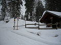
 View of the wayside cross and the refuge at the top of the pass |
|||
| Compass direction | east | west | |
| Pass height | 1137.6 m above sea level NHN | ||
| state | Baden-Württemberg | ||
| Valley locations | Column | Menzenschwand | |
| expansion | Pass road L 146 | ||
| Mountains | Black Forest | ||
| Map (Baden-Württemberg) | |||
|
|||
| Coordinates | 47 ° 49 '38 " N , 8 ° 5' 17" E | ||

The Äulemer Kreuz is a 1137.6 m above sea level. NHN high pass in the Black Forest .
Geographical location
The pass road crosses a ridge starting from the Feldberg between Kapellenkopf ( 1273 m ) in the north and Schnepfhalde ( 1290 m ) in the south. It connects the places Äule (in the east) and Menzenschwand (in the west), or the Schluchsee and the Menzenschwander valley.
Surname
The name Äulemer Cross comes to a crossroads back to the pass, which is named after the nearby village Äule.
tourism
summer
There are several parking spaces at the Äulemer Kreuz, which are the starting point for hikes in the Feldberg or Schluchsee area or offer views (into the Menzenschwander Valley).
winter
In winter, the top of the pass is the starting point for two cross-country trails :
- Äulemer-Kreuz-Loipe (also "Menzenschwander Spur", 9.2 km) around Silberfelsen and Kapellenkopf to Farnwitte ( 1235 m ), with connection to the Loipen on Feldberg, altitude difference 100 m, classic
- Habsberg lane Blasiwald (10.5 km, with a 3.5 km long connecting trail to the Äulemer Kreuz) around the Upper Habsberg ( 1274 m ), height difference 150 m, classic
Over parts of the two trails (from the Farnwitte ( 1235 m ) to the Roßhütte ( 1205 m )) runs an eight-kilometer section of the 32-kilometer long- distance skiing trail Hinterzarten – Schluchsee .

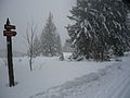
Pass top with bus stop and parking lot. The Äulemer Cross can be seen on the right
Loipenhaus at the cross-country skiing center Äulemer Kreuz
The Farnwitte, a high pasture, at the turning point of the Äulemer-Kreuz trail


