Brugga (Dreisam)
| Brugga | ||
|
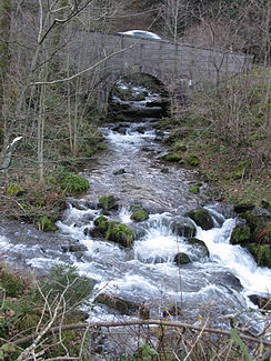
The Buselbach crosses under Notschreistraße and joins the St. Wilhelmer Talbach (from left) to form Brugga |
||
| Data | ||
| Water code | DE : 233884 | |
| location |
Black Forest
|
|
| River system | Rhine | |
| Drain over | Dreisam → Elz → Rhine → North Sea | |
|
Source (Hauptquellbach St. Wilhelmer Talbach) |
the main upper reaches St. Wilhelmer Talbach: west of the field Berg -Gipfels 47 ° 52 '8 " N , 7 ° 59' 27" O |
|
| Source height | approx. 1305 m above sea level NN | |
| muzzle | At the Kirchzarten golf course from the left and southeast in the Dreisam coordinates: 47 ° 58 '46 " N , 7 ° 54' 50" E 47 ° 58 '46 " N , 7 ° 54' 50" E |
|
| Mouth height | approx. 326 m above sea level NN | |
| Height difference | approx. 979 m | |
| Bottom slope | approx. 54 ‰ | |
| length | 18.2 km with the upper reaches of St. Wilhelmer Talbach |
|
| Catchment area | 62.387 km² | |
| Discharge at the St. Wilhelm A Eo gauge : 15.2 km² |
NNQ MNQ 1954–2003 MQ 1954–2003 Mq 1954–2003 MHQ 1954–2003 HHQ (1991) |
80 l / s 130 l / s 670 l / s 44.1 l / (s km²) 6.8 m³ / s 11.6 m³ / s |
| Discharge at the Oberried A Eo gauge : 40.1 km² |
NNQ (1964) MNQ 1933-2003 MQ 1933-2003 Mq 1933-2003 MHQ 1933-2003 HHQ (1944) |
100 l / s 350 l / s 1.53 m³ / s 38.2 l / (s km²) 16.18 m³ / s 33.6 m³ / s |
| Discharge at the mouth of the A Eo : 62.73 km² |
MQ Mq |
2.1 m³ / s 33.5 l / (s km²) |
| Communities | Oberried , Kirchzarten | |
The Brugga is a good 18 kilometers long left tributary of the Dreisam in the southern Black Forest east of Freiburg im Breisgau ( Baden-Württemberg , Germany ). The name Brugga leads the brook from the confluence of the St. Wilhelmer Talbach with the smaller Buselbach . The Brugga runs in one of the deepest valleys in the German low mountain range and is hydrologically researched intensively.
geography
Spring streams
St. Wilhelmer Talbach
The St. Wilhelmer Talbach flows through a stretched north-west running, steep trough valley , which lies almost exactly on the line connecting the peaks of Schauinsland (1284 m) and Feldberg (1493 m). The stream rises at a height of 1305 meters from a kar-like high trough west of the Feldberg and, after the alpine path has crossed it, falls steeply over 200 meters into the Napf valley head of the St. Wilhelmer Valley. The forest of the steep slopes is protected as a protected forest .
After the confluence of the Wittenbach, which descends from a hanging valley from the left , the valley floor, which was broadened by the glaciers of the last Ice Ages , allows livestock farming; this is why the upper populated section of the valley begins here. At the confluence of the next brook from the stepped hanging valley Katzensteig , again coming from the left, the relief is particularly rich in various glacial forms. The center of St. Wilhelm is also here with the remains of the former monastery of the same name. After a run of 7 kilometers, the brook flows together with the Buselbach, whose water flow it exceeds by half with an average discharge of 0.66 m³ / s.
Buselbach
The Buselbach rises at a height of around 1130 meters from a hollow in the north-west of Haldenköpfles (1265 m), which is the highest point on a plateau south of the Schauinsland. Like some of its left tributaries from this high plateau, the Buselbach initially only has a moderate gradient and flows through a series of sloping hollows that are largely made up of spruce forests.
Notschreistraße (L126) follows it to the northeast for almost its entire length . Its four double turns each indicate one of the valley steps created by glacial erosion, over which the Buselbach falls in small gorges and waterfalls. The largest waterfall is on the second level between the Rossboden boiler and the valley floor at the melting point ; its two main falls lie in the semi-darkness of a short ravine . The brook reaches the valley basin with the Steinwasen Park via two other smaller waterfalls , and then plunges steeply down to the level of the lower-lying St. Wilhelmer Valley. After around 4.3 kilometers, the Buselbach flows together with the St. Wilhelmer Talbach. It supplies the resulting Brugga with around 0.43 m³ / s of water on average.
course
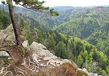
Just below the confluence at the Hohe Brücke , the Brugga plunges through a rocky narrow pass. In the following, northward running section, the valley now hardly has a trough shape; however, this section of the valley widens in some places. It reaches a depth of around 800 meters between Schauinsland (left) and Hochfahrn (1264 m). In the German low mountain ranges only the valley of the Wild Gutach is cut deeper.
Below Oberried, the Zastlertal flows from the right, but the Zastlerbach has not flowed into the Brugga for centuries, but initially in an artificial bed as an Osterbach along the eastern side of the valley and a total of more than 6 kilometers as a close right companion of the Brugga to Dreisam. The valley floor, the Schlempenfeld , which is around 500 meters wide from the former monastery town of Oberried , merges into the plain of the Zarten basin at Kirchzarten . From here the Brugga runs in noticeable turns. Shortly before the confluence with the Dreisam on the city limits of Freiburg , the Brugga takes its largest tributary from the left, the Reichenbach, which approaches from the Schauinsland down through the Kapplertal. With a water flow of around 2 m³ / s, the Brugga is the second largest watercourse in the Zartener Basin.
Tributaries
List of the tributaries and the tributaries of both upper courses, each from the source to the mouth. Water length and catchment area according to the corresponding layers on the LUBW online map. Other sources for the information are noted.
Selection.
- St. Wilhelmer Talbach, right upper reaches from the southeast, 7.0 km and 15.3 km²
- (Bach vom Stübenwasen ), from the left and south-west, 0.7 km
- (Stream from the St-Wilhelmer Hütte), from the right and southeast, 1.2 km
- (Bach from the Kammertobel ), from the right and southeast, 1.1 km
- Hüttenwasenbächle, from the right and east in the first valley direction, 1.1 km
- Schwarzenbach, from the right and northeast at the end of the first valley direction, 0.9 km
- Wittenbach , from the left and south at the Kühmatteshof, 2.1 km and 2.0 km²
- Erlenbächle, from the right and northeast near the Albrechthof, 1.8 km and 1.4 km²
- Katzensteiger Bach, from the left and southwest at the Schneeschneidershof, 1.7 km and 1.6 km²
- (Bach from the Gewann Katzensteig ), from the left and southwest in Sr. Wilhelm, 1.1 km
- (Bach from the Gewann Holzbruck ), from the left and southwest immediately to St. Wilhelm, 0.9 km
- Fuchsbach , from the right and northeast, 1.4 km and 0.8 km²
- Buselbach, left upper course from the south, 4.4 km with the upper course Schwarzenbach and 12.3 km²
- (Brook from the edge of the forest south of Halde), left upper course from the west, 2.5 km
- Schwarzenbach, right upper reaches from the southeast, 1.9 km
- Grummenbach, from the right and southeast at Schmelzplatz, 2.1 km
- Haldenbächle , from left and west, 2.0 km
- Steinwasenbach, from the left and west at Steinwasenpark, 2.6 km
- (Stream from the western slope of the Gfallmatte ), from the right and east just before the next, 0.9 km
- Tiefenbach, from the left and west just before the rear Schneeberghof, 1.8 km
- Langau, from the left and west in the forest to the Schneeberghof, 1.7 km
- Schanzbach , from left and west to Hintertal, 2.0 km
- (Stream from the northwest slope of the Gfallmatte ), from the right and southeast a little after the previous one, 2.6 km and 1.2 km²
- Wittelsbach, from the left and west in Oberried, 2.4 km and 1.8 km²
- Vörlinsbach, from the right and south near the monastery in Oberried, 2.1 km
- Geroldsbach , from the left and southwest near Geroldstal, 2.2 km
- → (exit of the Mühlbach ), to the right, 1.1 km. From the left flows into the Krummbach called dprt Zastlerbach
- (Stream from the Gewann Jungbauernhof ), from the left and south-west near the Jungbauernhof, 0.9 km
- Dietenbächle, from the left and southwest at the Kernenmühle, 2.1 km
- Krebsgraben , from the left and south at the ore laundry, 3.0 km
- Reichenbach , from LR, 8.2 km and 13.5 km²
Runoff regime
In the Brugga catchment area, around two thirds of the precipitation falls as snow. The strongest runoff therefore occurs during the snowmelt in April. In August and September, i.e. at the end of the summer phase of high evaporation, the lowest runoff is measured. Because of the steepness of the relief, a lot of water drains off before it can evaporate. Mainly because of the high rainfall, the area runoff is very high at over 38 l / s · km². Despite the steep slopes and the dense crystalline rocks ( granite and anatexite ), the ratio of mean high and low water is only about 45 and thus a value that is clearly exceeded by some of the surrounding streams. A steady effect on the runoff is attributed to the extensive, water-storing tunnel systems that ore mining has left in the area around the Schauinsland.
Cultural landscape aspects
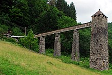
The Bruggatal has a poorly accessible topography. Notschreistrasse between the Dreisamtal and the Wiesental was not completed until 1848 . The founding of the monasteries Oberried and St. Wilhelm promoted the economic development of the valley, in which ore mining was bypassed for centuries. This is reflected in mountain names such as Dead Man northeast of the St. Wilhelmer Valley and Erzkasten , as the Schauinsland was called for a long time. There was an ore laundry on the lower Brugga . The Barbarastollen near the Brugga now serves as the central salvage site for the Federal Republic of Germany . Apart from an old hydroelectric power station, the Brugga is hardly used to generate energy. Intensive tourist use is limited to the Steinwasen amusement park ; otherwise the valley is mainly used for quiet relaxation. The Brugga is a target for whitewater paddlers when the water level is high .
Individual evidence
LUBW
Official online waterway map with a suitable section and the layers used here: Course and catchment area of the Brugga
General introduction without default settings and layers: State Institute for the Environment Baden-Württemberg (LUBW) ( notes )
- ↑ a b c Length according to the waterway network layer ( AWGN ) .
- ↑ a b c Catchment area summed up from the sub-catchment areas according to the basic catchment area layer (AWGN) .
- ↑ Catchment area according to the basic catchment area layer (AWGN) .
Other evidence
- ↑ Günther Reichelt : Geographical land survey: The natural spatial units on sheet 185 Freiburg i. Br. Federal Institute for Regional Studies, Bad Godesberg 1964. → Online map (PDF; 3.7 MB)
- ↑ a b Digital topographic map
- ↑ a b Jens Didszun: Experimental investigations on the scale dependence of the runoff formation (PDF; 4.1 MB). Freiburger Schriften zur Hydrologie 19, 2004, pp. 1–221
- ↑ Discharge of the Oberried water level (with Mq: 38.4 l / s.km²), increased by the discharge of the remaining catchment area, for which the area discharge of the topographically comparable water level Wiesneck am Wagensteigbach (Mq: 23.5 l / s.km²) is assumed is (rounded)
- ↑ St. Wilhelm gauge a little above the confluence
literature
- Topographic map 1: 25,000 Baden-Württemberg, as single sheet No. 8013 Freiburg im Breisgau Südost, No. 8113 Todtnau and No. 8114 Feldberg (Black Forest)


