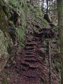
Alpine path
The Alpine Path or Alpine Steig is one of the highest hiking trails in the Black Forest . Between Hüttenwasen and Stübenwasen , the path runs largely horizontally through the rocky northern slopes of the Feldberg . The three and a half kilometers long path was abandoned by the forest administration in order to promote the development of nature there.
location
The path runs above the Napfs, the head of the St. Wilhelmer Valley and below the St. Wilhelmer Hut and the Feldberg summit. From Hüttenwasen, it runs clockwise around the Napf, about halfway between the Feldberg summit and the valley floor.
The Alpine path can be reached from the Stollenbacher Hütte (access from the Zastlertal ) or the Erlenbacher Hütte (access from Oberried ) on the Toten Mann via the Hüttenwasen, as well as from the Todtnauer Hütte (via the Stübenwasen).
Characteristic
The path is a special feature of the landscape, as it is one of the few hiking trails in the Black Forest that lead through distinctly alpine terrain with rocks and steep ravines . Other paths to which this applies are the Felsenweg above the Feldsee , a path on the Schultiskopf above the Simonswälder Valley , the Felsenweg near Oberried and the connection from the Feldbergpass to the Bernauer Kreuz . In addition, the path bears its name because of the alpine vegetation, which has one of its last retreats in the Black Forest on the north side of the Feldberg, which is turned away from the sun and is difficult to access.
The Alpine path leads through mixed forest consisting of beech , mountain ash , sycamore maple , spruce , silver fir and Douglas fir , with the conifers predominating. The path also passes rock faces, avalanche tracks and the forest-free cattle pastures typical of the Black Forest's agricultural use (on Hüttenwasen and below St.-Wilhelmer-Hütte). T. pioneer vegetation can be found. The environmental damage of recent years can also be seen particularly clearly in the numerous tree skeletons that stand below the Feldberg summit and Stübenwasen. The path ends directly behind the Stübenwasenkreuz.
The path has not been signposted and maintained by the Black Forest Association for several years . Nevertheless, it is still accessible and is occasionally equipped with self-made wooden signs or red markings on a private initiative. In many places the path is blocked by fallen or felled trees. In summer it is usually overgrown and sometimes difficult to see. This applies in particular to the access (or exit) from Stübenwasen and the descent to St. Wilhelm.
Individual evidence
- ↑ Ninja Friedel: District of Breisgau-Hochschwarzwald: Feldberg: Alpine path: Abandoned by the forestry office - an insider tip for hikers , Badische Zeitung, August 20, 2011, accessed on January 21, 2013
Coordinates: 47 ° 52 ′ 14 " N , 7 ° 58 ′ 4" E


