Simonswälder Valley
| Simonswälder Valley | ||
|---|---|---|
|
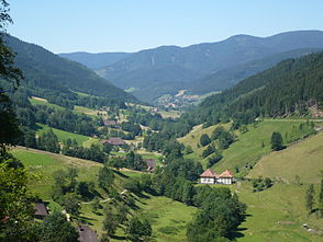
Obersimonswald (around 450 m), with Obereck (1178 m, right) and Zweribachwerk (front right) |
||
| location | Baden-Wuerttemberg , Germany | |
| Mountains | Black Forest | |
| Geographical location | 48 ° 6 ' N , 8 ° 3' E | |
|
|
||
| length | 25 km | |
The Simonswälder Tal is an approximately 25 km long side valley of the Elz in the central Black Forest . The narrow upper section of the valley is known as the Wildgutach valley .
geography
The Simonswälder Tal flows into the Elz at Bleibach (district of Gutach im Breisgau ) near Waldkirch , coming from the southeast, and is traversed by the Wilden Gutach . Administratively, this typical Black Forest valley largely belongs to the municipalities of Simonswald and Gütenbach .
In addition to the main valley, some of the eight side valleys (Etters-, Gries- and Nonnenbachtal or the Haslachsimonswälder valley), as well as the plateaus ( Platte , Gütenbach) are settled. Many centuries-old farms, mills ( Hexenlochmühle ) and chapels (Hofrainkapelle, Schmidtbauernkapelle, Kapelle am Eckle), as well as wayside crosses ( Balzer Herrgott ) have been preserved.
The valley area is flanked on the left by the mountains Kandel ( 1241 m above sea level ) and Hornkopf ( 1121 m above sea level ), and on the right by Hörnleberg ( 906 m above sea level ), Obereck ( 1178 m above sea level ) and Brend ( 1149 m above sea level ). The valley flanks have steep slopes up to 700 meters high and are structured by angular mountain ridges, cirques from the last ice ages , gorges ( Kostgfall Gorge , Teichschlucht ) and waterfalls ( Zweribach waterfalls , Hirschbach waterfalls ). Large parts of the valley are protected (nature reserve and protected forest area Zweribach , nature reserve Kostgefäll , FFH area ).
For further geographic information see Wilde Gutach .
history
The Simonswälder Valley was first mentioned in a document on August 5, 1178, although the settlement certainly began much earlier. The history and settlement of the Simonswälder Valley goes back to the high mediaeval times of the monastic land grabbing and clearing of forests, when around 900 St. Severin was the first Christian church in the region on the Mauracher Bergle . The Simonswälder Tal belonged to the possessions of the St. Margarethen women's monastery in Waldkirch and, with its settlements, formed its own large Meiertum , which can be regarded as the forerunner of today's Simonswald community. There are indications that the mountain crossing over the Black Forest through the Kilpachtal to Rottweil already existed in Roman times.
Origin of name
The Sigmannswald appears for the first time in 1178 in a document from the St. Margarethen monastery (Waldkirch).
According to legend, Simon von Walde and his entourage on horseback regularly come to the St. Severin Chapel on the Mauracher Bergle for church services.
Economy and trade
The place Simonswald has today after the voluntary amalgamation of the once independent places Unter-, Alt-, Ober- and Haslachsimonswald as well as Wildgutach on January 1st 1974, around 3100 inhabitants (as of January 2008). In addition to the dominant tourism industry, which experienced a rapid boom in the 1950s, there is small industry (precision and watchmaking) as well as handicrafts and trade. The farms make their main and sideline income from animal husbandry and forestry. Agriculture is only possible to a limited extent in the lower valley areas. The name "Rebbergweg" suggests that wine was also grown here in the past.
Tourism and leisure
The road through the valley is part of the German Clock Road , which runs through the Black Forest from Waldkirch to Rottweil.
The term “ZweiTälerLand” was created for the tourist marketing of the Simonswälder Valley and the Elz Valley, and is used by the Elztal & Simonswäldertal Tourismus GmbH & Co. KG to advertise. This also includes the cone traffic concept .
Landscape protection area
On August 17, 1942, the Simonswälder Valley with two sub- areas was declared a landscape protection area by ordinance of the Baden Ministry of Education and Culture as a higher nature conservation authority . The area has a total size of 6,767 hectares, of which 500 hectares are in the Schwarzwald-Baar district (protected area number 3.26.010) and 6,267 hectares in the district of Emmendingen (protected area number 3.16.004).
literature
- Rudolf Schiffer: Simonswald. "The little Allgäu in the Black Forest". In: REGIO Magazin, Freiburg im Breisgau. JG 10, No. 6, June 1993, pp. 20-23.
Web links
- Profile of the landscape protection area in the protected area directory of the LUBW


