
Pond gorge

The pond gorge is located in the northern Black Forest (also the southern Central Black Forest ) and forms the border between Gütenbach ( Schwarzwald-Baar district ) and Simonswald ( Emmendingen district ). The Teichbach (once Woutenbach ) , which comes from four high valleys around Gütenbach, plunges through them southwest to the Wilder Gutach . It also marks the upper end of the valley section of the Wild Gutach called Simonswälder Tal . In the ravine-like Kerbtal with an average gradient of almost 13 percent, the Teichbach overcomes an altitude difference of around 250 meters as a torrent with many blocks and three cascade groups . The steep slopes, up to 400 meters high, are characterized by large scree slopes, some of which are free of forest , and are interspersed with cliffs. Opposite the pond gorge, the waterfall-rich Zweribach-Kar flows into the main valley.
Geography and geology
The Teichschlucht is part of one of the most rugged valley landscapes in the German low mountain range. The valley was formed over by glaciers during the past ice ages , but this is hardly noticeable because of the thick debris cover. The blocked bed of the often very watery brook occasionally shows typical fluvial erosion forms . The entire gorge with its typical gorge forest and montane spruce, fir and beech mixed forests is designated as a protected forest area.
The road from Waldkirch to Furtwangen runs halfway up the rocky northern slope of the valley .

Names
In old sources still called dike or dike gorge , it has appeared on maps as a pond gorge since the 1950s . For the name, as well as for the brook name pond , which occurs several times in the upper Murg valley , an explanation seems to be pending .
The place name Gütenbach is also related to the impetuous torrent: around 600 years ago, the then young settlement of Woutenbach or Wuttenbach , i.e. the "angry brook", was mentioned (see Wutach ). In Gütenbach, however, the stream flows much more calmly than below.
tourism
In the 1920s, the pond gorge was opened up by the Gütenbach local group of the Black Forest Association under the leadership of Erwin Schwer at the time, and a hiking trail was created along the course of the stream , today a part of the cross-way Black Forest – Kaiserstuhl – Rhine and in the lower area of the Zweälersteig . Although the path was built at a suitable distance from the watercourse, the Teichbach tore part of the hiking path with it in 1993. A section of the adventure hiking trails around Furtwangen runs above the pond gorge. The rocks in the pond gorge are also a target for climbers.
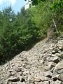
Scree slope on the northern side of the gorge
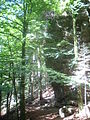
Hiking trail through the gorge

Climbing rocks in the gorge


There are numerous other hiking destinations close to the pond gorge, such as the Zweribach waterfalls , the Balzer Herrgott or the Hexenlochmühle .
Sources and web links
Coordinates: 48 ° 2 ′ 20 ″ N , 8 ° 7 ′ 16 ″ E