
Zweribach waterfalls
The Zweribach waterfalls are located 20 kilometers east of Freiburg in a part of the Upper Black Forest , which is counted as part of the Central Black Forest . Over the approximately 40-meter-high waterfalls plunges Zweribach into Simonswälder Valley , where he worked in the Wilde Gutach flows.


Location and natural space
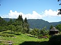
The Black Forest is known for its wealth of waterfalls, a result of the often large differences in altitude over a short distance below high valleys. On the 300 to 700 meter sloping western flank of the Simonswälder Valley, the strong ice age glaciations have created particularly steep cirque walls . The Zweribach and Hirschbach brooks , which run in gently undulating hanging valleys above waterfalls, plunge into the largest of these cirques, which is over 300 meters deep . The former main glacier of the valley basin came from the more southern Hirschbachtal; its northern lateral moraine runs through the basin below the Zweribach Falls. These are located in the Karwand at a height of around 800 meters and have three levels, with heights of fall of 8 meters, almost 3 meters and finally 15 meters.
In the natural area on a montane slope , there is an Atlantic-toned climate . On the Sundays as well as shady side slopes of karförmigen basin have loamy - grusige Ranker formed by rocks and scree slopes are interspersed. The original canyon forest vegetation is anthropogenic overprinted by meadow , pasture and Reutberg farming .
Protected areas and research
The falls are located in the middle of the Zweribach nature reserve . The Zweribach spell forest was first designated as early as 1970 in the St. Märgen forest district . The Bannwald area on the Zweribach is one of the oldest natural forest reserves in Germany .
The Geographical Institute of the University of Freiburg is carrying out the project "Usage-related changes in selected mountain forest ecosystems - focus on soils - in the Black Forest and in the Vosges " at the Zweribach .
Tourism and leisure
The Zweribach waterfalls are particularly popular with hikers on weekends . Usual starting points are in the valley east of the falls of the Simonswald district Wildgutach and the Hexenlochmühle , on the mountain in the west St. Märgen and the plateau of the Platte . The shortest way is signposted access via the parking lot in Wildgutach at the end of the Zweribachweg at the Zweribachbrücke / Hirschwinkelweg. From there, going steadily upwards, after a left bend, turn right and pass the Bruggerhof to the courtyard of the burned-down Brunnenhof with remains of walls, a chapel and a Vesper square with a refuge. After a turnoff to the left to the Hirschbach Falls 0.6 km away , the rock climb leads securely and over steps through the forest to the waterfalls. The path crosses it over a steel bridge and then serpentines uphill to the plate .
The Zweribach waterfalls have been a destination for ice climbers in winter for several years .
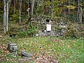
Remains of the fountain courtyard
Vespers square with chapel


Use of hydropower

The Zweribachwerk hydropower plant was built in 1924; it stands noticeably downhill from the falls in the Wild Gutach valley. Its fall water is fed to it via a pipeline from Lake Balaton , a reservoir on the Platte plateau in the course of the Zweribach. Therefore only part of the natural water flow of the stream falls over the falls, which is particularly noticeable in summer.
Sources and web links
- Katrin Bürger: Usage-related changes in selected mountain forest ecosystems - focus on soils - in the Black Forest and in the Vosges. Archived from the original on July 6, 2007 ; Retrieved August 18, 2013 .
- Hiking tips from Freiburg-Schwarzwald.de
- Collective ordinance of the Freiburg Forestry Directorate on the “Conventwald”, “Faulbach”, “Feldseewald”, “Hirschfelsen”, “Zweribach” forests (PDF; 28 kB)
- Thomas Ludemann: In Zweribach - From the post-glacial primeval forest to the “primeval forest of tomorrow”. The vegetation of a valley landscape in the Middle Black Forest and its change over the course of the seasons and centuries (= State Institute for Environmental Protection Baden-Württemberg (Hrsg.): Supplements to the publications for nature conservation and landscape management in Baden-Württemberg 63). Karlsruhe 1992, ISBN 3-88251-171-0 .
Coordinates: 48 ° 2 ′ 35 ″ N , 8 ° 5 ′ 35 ″ E