
Hirschbach Falls
_gro%C3%9Fer_Hirschbach-Wasserfall_Bild_3.jpg)
The Hirschbach Falls are located between St. Peter and Simonswald in the part of the Upper Black Forest that is also included in the central Black Forest . In the almost 20 meter high, stepped main fall, the Hirschbach falls into an Ice Age cirque in the Simonswälder Valley , where it flows into the Zweribach , a tributary of the Wild Gutach . Two other smaller waterfalls are 300 meters upstream in the Gschwandersdobel high valley .
Scenic framework
The Black Forest is known for its wealth of waterfalls. The reason for this lies in the large differences in altitude over a short distance, which is particularly true of the topographical situation in the Simonswälder Valley. In the 300–700 meter sloping western flank of the valley, the strong ice age glaciations have created karwalls . The neighboring creeks, Hirschbach and Zweribach, which come from gently undulating hanging valleys , plunge down into the largest of these cirques with a depth of over 300 meters, with several waterfalls, of which only the Zweribach waterfalls are known nationwide. The cirque is protected as a spell forest and as a nature reserve Zweribach .
The waterfalls in Gschwandersdobel (upper falls)
At the end of the high valley in which its headwaters lie, the Hirschbach falls over a valley step reinforced by the former glacier activity and cuts into the Gschwandersdobel valley in the process . In it, it forms a three-meter-high drop step at a height of 922 meters and a good hundred meters further on a step of almost 5 meters at a height of 898 meters.

Upper waterfall (3 m)
Lower waterfall (5 m)
_oberer_Wasserfall_im_Gschwandersdobel.jpg)
_unterer_Wasserfall_im_Gschwandersdobel.jpg)
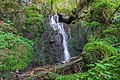
The main stages (lower Hirschbach Falls)
The lower Hirschbachfall, the main one, falls from a height of 863 meters almost 20 meters deep in four steps into the rugged Groß-Kar. The brook has cut into the cliff-rich Karwand like a kerbtal valley. The falls are the beginning of a very steep, block-rich torrent section in which the stream loses about 120 meters in height.

Hirschbach Falls (20 m)

Hirschbach Falls in the Kerbtal

Felsensteig between the Hirschbachfall and the Zweribach waterfalls
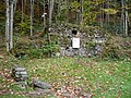
Remains of the Brunnenhof below the Hirschbach Falls
Vesperplatz with chapel below the Hirschbach Falls

_gro%C3%9Fer_Hirschbach-Wasserfall_Bild_1.jpg)


tourism
The Hirschbach Falls can only be reached on foot. The lower Hirschbachfall is, mostly in connection with the nearby Zweribach waterfalls, the destination of hikes from the Simonswälder Valley, the Hexenlochmühle or from St. Märgen . The signposted ascent from the parking lot at the Zweribachbrücke is shorter. You pass the Bruggerhof, the former courtyard of the burned down Brunnenhof (remains of the wall, chapel, today Vesperplatz with refuge) and the path branching off to the right to the Zweribach waterfalls. Over a narrow rocky path, an overgrown scree field, as well as bridges and stairs secured with ropes and handrails, you get to the waterfalls, steadily climbing up to 600 meters through the forest. If you follow the paths up the valley near the stream ( orographic right), you will also reach the upper falls in Gschwandersdobel. The waterfalls can also be reached from the plateau of the plate .
See also
- Teichschlucht (2 kilometers east, on the other side of the Simonswälder Valley)
- List of waterfalls in Germany (comparative overview, other neighboring waterfalls)
Web links
Coordinates: 48 ° 2 ′ 6 " N , 8 ° 5 ′ 33" E