
Elz (Rhine)
| Elz | ||
 Course of the Elz |
||
| Data | ||
| Water code | EN : 2338 | |
| location |
Black Forest
|
|
| River system | Rhine | |
| Drain over | Rhine → North Sea | |
| source | at Furtwangen 48 ° 6 ′ 7 ″ N , 8 ° 9 ′ 47 ″ E |
|
| Source height | 1038 m above sea level NHN | |
| muzzle | as Alte Elz near Kehl -Kronenhof in the Rhine Coordinates: 48 ° 33 '27 " N , 7 ° 48' 26" E 48 ° 33 '27 " N , 7 ° 48' 26" E |
|
| Mouth height | 137 m above sea level NHN | |
| Height difference | 901 m | |
| Bottom slope | 7.4 ‰ | |
| length | 121.1 km via Alte Elz | |
| Catchment area | 1539 km² | |
| Discharge at the Riegel gauge (Add.) A Eo : 1102 km² Location: 12.3 km above the mouth |
NNQ (08/25/2003) MNQ 1980 * 2009 MQ 1980 * 2009 Mq 1980 * 2009 MHQ 1980 * 2009 HHQ (12/22/1991) |
925 l / s 3.35 m³ / s 21.7 m³ / s 19.7 l / (s km²) 179 m³ / s 360 m³ / s |
| Left tributaries | Wilde Gutach, Glotter / Lossele, Dreisam, Eichstetter Mühlbach | |
| Right tributaries | Biederbach, Brettenbach, Bleiche, Ettenbach , Kaputzinerbach | |
| Medium-sized cities | Waldkirch , Emmendingen | |
| Small towns | Elzach , Kenzingen | |
| Communities | Winden im Elztal , Gutach im Breisgau , Teningen , Riegel am Kaiserstuhl | |
 View southeast over the middle Elz Valley and Waldkirch to Hörnleberg , Obereck and Kandel (right) |
||
The Elz is an approximately 121 km long, right-hand tributary of the Rhine in the Black Forest and in the Upper Rhine Plain , Baden-Württemberg .
Surname
There are several explanations for the origin of the name in the literature. According to Berger (1999), the name of the Elz is pre-Germanic and derives from the Indo-European * el - / * ol- (= drift, move, flow) or the river name “Alantia” . This derivation also applies to the two other rivers “Elz” that flow into the Moselle and Neckar. Kleiber (1997: 244), on the other hand, writes, "the name Elz ... is derived from the Celtic old or * Altia 'the high, ie that comes from the high'".
According to Berger (1999) the names "Helzaha fluvium" (763), "Elzach" (1234) and "Elza" (1335) are documented.
- Aerial photos

View up the Elz over Emmendingen to the Kandel
"Alte Elz" between Kenzingen and Rheinhausen (Breisgau)

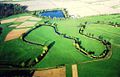
Aerial view of Obere Elz, looking north

Canalized Elz near Riegel am Kaiserstuhl


geography
course
The Elz springs north of Furtwangen in the area of Brend and the tube Hardenbergs (between the Furtwänglehof and the Kolmenhof) close to as hydrographic Donauquelle applicable Breg source.
In the upper reaches the Elz flows in a northerly direction, first through a high valley with meadows, moors and forms shaped by Ice Age glaciers, then, after a steep step with the small Elz falls , through a deeply indented, hardly populated forest valley. In Oberprechtal, it bends sharply to the southwest. This is where the middle, actual Elz Valley begins, which leads straight to the southwest and separates the 700 to 900 meters sloping Black Forest in the southeast from much lower parts of the Middle Black Forest . In the now densely populated valley, the town of Elzach is followed by the towns of Winden and Gutach im Breisgau , where the Elz flows into the Wilde Gutach, which is almost half the size. Below the town of Waldkirch , the Elz flows into the Freiburg Bay of the Upper Rhine Plain near Denzlingen . From then on, it flows in a north-westerly direction, passing Emmendingen and Teningen . Part of the water from the Elz is directed from the Kollmarsreuter Weir over a Mühlbach through Emmendingen, where it powers several hydropower plants and enhances the cityscape. In Riegel am Kaiserstuhl the Elz hit that from Freiburg coming Dreisam and the Old Dreisam each other.
Soon afterwards the Elz forks again: A certain amount of water (up to 8.5 m³ / s) flows over the Alte Elz past Hecklingen through Kenzingen and then through the Europapark Rust to the later confluence with the Rhine. Water volumes in excess of this, on average around 13.2 m³ / s, are directed further up the river via the Leopold Canal, which was artificially created under the direction of Johann Gottfried Tulla , northwest of Rheinhausen into the Rhine. The Alte Elz used to flow into the Rhine near Schwanau . Today it is routed over various old Rhine channels parallel to the Rhine to the southern outskirts of Kehl and thus reaches a length of 121 kilometers on its longest flow path; it used to be a good 90 kilometers.

Source of the Elz

High valley above the Kerbtal of the Elz
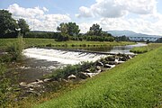
Wassermer weir, south of Emmendingen


Tributaries
The table lists all tributaries that are longer than 5 kilometers, with the exception of the mill canals that accompany the river. According to the river code number, the Frischnaubach is the uppermost tributary that flows into the Elz in the Prechtal district , the Ettenbach is the lowest tributary and flows into the Elz just before Kappel . All tributaries have their catchment area in the district of Emmendingen , except for the Ettenbach, which is located in the district of Ortenau .
There are two special cases in the table: Although the Alte Dreisam flows into the Elz together with the Dreisam, it is officially listed as a tributary of the Dreisam and thus as a 2nd order tributary of the Elz - against the background of the former common course. The Leopold Canal is listed as a branching body of water, as it takes up around two thirds of the water flow on average, leaving only around one third to the Alte Elz . Both special cases are highlighted in darker gray .
|
Stat. in m |
GKZ | Surname | from |
MQ in m³ / s |
Name Elz |
MQ Elz in m³ / s |
Length in km |
EZG in km² |
Mouth at |
Height in m above sea level NN ; |
comment |
|---|---|---|---|---|---|---|---|---|---|---|---|
| 98,912 | 2338-12 | Frischnaubach | re. | 0.26 | Elz | 1.58 | 5.7 | 11.6 | Elzach -Eilet | 477.8 | |
| 95,745 | 2338-194 | Yachbach | left | 0.55 | Elz | 2.00 | 7.8 | 19.5 | Elzach, sewage treatment plant | 343 | |
| 95,434 | 2338-2 | Biederbach | re. | 0.72 | Elz | 2.55 | 10.3 | 31.8 | Elzach, end of town | 340 | |
| 91.997 | 2338-32 | Spitzbach | re. | 0.23 | Elz | 3.52 | 6.4 | 11.0 | Winden in the Elztal - Niederwinden | 317 | |
| 87,349 | 2338-392 | Siegelbach | re. | 0.28 | Elz | 3.97 | 6.4 | 13.4 | Gutach im Breisgau tunnel | 289.0 | |
| 86,934 | 2338-4 | Wild Gutach | left | 4.40 | Elz | 4.25 | 25.2 | 129.9 | Gutach im Breisgau | 287 | |
| 85.966 | 2338-512 | Talbach | left | Elz | 9.03 | 6.2 | 9.1 | Gutach im Breisgau | 281 | ||
| 83,477 | 2338-53126 | Altersbach | left | Elz | 6.6 | 6.7 | Waldkirch | 266 | |||
| 80,463 | 2338-532 | Dettenbach | left | 0.18 | Elz | 9.18 | 6.2 | 9.8 | Waldkirch, end of town | 247 | |
| 77,985 | 2338-54 | Lossele | left | 1.26 | Elz | 9.43 | 20.1 | 49.8 | Denzlingen | 236.8 | right and main lower reaches of the glotters |
| 70,420 | 2338-6 | Brettenbach | re. | 1.29 | Elz | 10.69 | 24.2 | 71.2 | Emmendingen | 192 | |
| 63,341 | 2338-8 |
Dreisam (without Alte Dreisam) |
left | 8.56 | Elz | 12.18 | 48.8 | 449.66 | Riegel at the Kaiserstuhl | 178 | |
| 18th | 2338-894 | Old Dreisam | left | 2.30 | Dreisam (Elz) |
23.04 | 38.2 | 197.15 | Riegel at the Kaiserstuhl | 178 | |
| 62,817 | 2338-9112 | Wihlbach | left | 0.06 | Elz | 23.04 | 5.0 | 4.9 | Riegel at the Kaiserstuhl | 177 | |
| 62,696 | 2337-920 | Leopold Canal junction |
left | 14.6 | Elz | 23.1 | 12.2 | Riegel at the Kaiserstuhl | 177 | ||
| 60,077 | 2338-912 | Malterdinger Dorfbach | re. | 0.14 | Old Elz | 7.64 | 6.6 | 15.8 | Kenzingen- Hecklingen | 177 | |
| 57,108 | 2338-914 | Little Elz | re. | 0.08 | Old Elz | 7.78 | 6.6 | 8.5 | Kenzingen | 176 | |
| 50.119 | 2338-92 | Bleichbach | re. | 0.80 | Old Elz | 7.89 | 18.4 | 60.8 | Herbolzheim , Mühlehof | 170 | |
| 47.273 | 2338-932 | Grundelbach | re. | 0.05 | Old Elz | 8.71 | 5.6 | 6.8 | Rust | 165 | |
| 42,231 | 2338-94 | Ettenbach | re. | 0.66 | Old Elz | 8.80 | 18.4 | 59.9 | Kappel-Grafenhausen - Kappel | 161 | |
| 38,466 | 2338-954 | Dew pouring | left | Old Elz | 8.9 | 8.7 | Kappel, sewage treatment plant | 157 | left diversion of the Alte Elz near Rust | ||
| 38.038 | 2338-96 | Kapuzinerbach | re. | 0.21 | Old Elz | 9.46 | 14.3 | 24.4 | Kappel, sewage treatment plant | 157 | |
| 36,831 | 2338-98 | Continuous old retraction | left | Old Elz | 9.67 | 43.2 | 134.2 | Schwanau- Wittenweier | 156 | right arm of the Rhine | |
| 24,316 | 2338-992 | Ottenheimer Mühlbach | re. | Rk / Mb | 9.7 | 13.8 | Schwanau- Ottenheim | 150 | right diversion at Schwanau-Wittenweier |
- ↑ Stationing, the distance from the mouth of the river up to this tributary. The Alte Dreisam is stationed accordingly at the Dreisam.
- ↑ Water code number , in Germany the official river code number . After the prefix common to all, namely the river code number of the Elz itself, a separator has always been inserted for better readability.
- ↑ Mean outflow of the inflow at the mouth; Information from: Abfluss-BW - regionalized discharge parameters Baden-Württemberg of the State Institute for the Environment, Measurements and Nature Conservation Baden-Württemberg (LUBW)
- ↑ Name of the section of the Elz at its mouth (Rk / Mb = Raukehle / Mühlbach)
- ↑ Mean natural discharge of the Elz at its mouth (Alte Elz: mean controlled discharge); Information from: Abfluss-BW - regionalized discharge parameters Baden-Württemberg of the State Institute for the Environment, Measurements and Nature Conservation Baden-Württemberg (LUBW)
fauna
Frequently occurring fish species in the Elz are:

Individual evidence
- LUBW
Official online waterway map with a suitable section and the layers used here: Course and catchment area of the Elz
General introduction without default settings and layers: State Institute for the Environment Baden-Württemberg (LUBW) ( notes )
- ↑ a b Length according to the waterway network layer ( AWGN ) .
- ↑ Catchment area after the layer aggregated areas 04 .
- ↑ Length according to the water network layer ( AWGN ) of the LUBW's online map server. The length can include upper reaches of different names and also name upper reaches in favor of hydrologically dominant tributaries to the name course.
- ↑ Catchment area according to the basic catchment area (AWGN) layer of the LUBW's online map server, partly summed up from sub-catchment areas, sometimes also measured. The last case was documented in the Comments column.
- ↑ Height according to the contour line image or according to labels on the background layer topographic map .
- ↑ a b c Catchment area measured on the background layer topographic map .
- ↑ The Altersbach flows into a nearby, roughly parallel commercial canal. Stationing roughly traced over to the Elz, corresponding to the height of the mouth.
- Other evidence
- ↑ Heinz Fischer: Geographical Land Survey: The natural spatial units on sheet 169 Rastatt. Federal Institute for Regional Studies, Bad Godesberg 1967. → Online map (PDF; 4.4 MB)
- ^ Heinz Fischer, Hans-Jürgen Klink: Geographical land survey: The natural space units on sheet 177 Offenburg. Federal Institute for Regional Studies, Bad Godesberg 1967. → Online map (PDF; 4.0 MB)
- ↑ Günther Reichelt : Geographical land survey: The natural spatial units on sheet 185 Freiburg i. Br. Federal Institute for Regional Studies, Bad Godesberg 1964. → Online map (PDF; 3.7 MB)
- ^ German Hydrological Yearbook Rhine Region, Part I 2009 State Institute for Environment, Measurements and Nature Conservation Baden-Württemberg, p. 81, accessed on January 22, 2016 (PDF, German, 1.85 MB).
- ↑ Berger, Dieter (1999): Geographical Names in Germany. Duden paperbacks, vol. 25.
- ↑ Kleiber, Wolfgang (1997): “The newly discovered Roman road connection between Baar (Hüfingen) and Breisgau (Zarten) in terms of onomatology.” In: Italica et Romanica. Festschrift for Max Pfister on his 65th birthday. Eds. Günter Holtus et al. Vol. 3 Tübingen: 239-252.
- ↑ Figure IG-Elz
literature
- Topographic map 1: 25,000 Baden-Württemberg, as a single sheet No. 7412 Kehl, No. 7512 Neuried, No. 7513 Offenburg, No. 7711 Weisweil, No. 7712 Ettenheim, No. 7713 Schuttertal, No. 7714 Haslach, No. 7715 Hornberg , No. 7811 Wyhl, No. 7812 Kenzingen, No. 7813 Emmendingen, No. 7814 Elzach, No. 7815 Triberg im Schwarzwald, No. 7911 Breisach am Rhein, No. 7912 Freiburg im Breisgau Northwest, No. 7913 Freiburg im Breisgau Northeast , No. 7914 St. Peter, No. 7915 Furtwangen, No. 8011 Hartheim, No. 8012 Freiburg im Breisgau Südwest, No. 8013 Freiburg im Breisgau Southeast, No. 8014 Hinterzarten, No. 8015 Titisee Neustadt, No. 8113 Todtnau, No. 8114 Feldberg (Black Forest)
Web links
- Map of the course and catchment area of the Elz on: State Institute for the Environment Baden-Württemberg (LUBW) ( information )
- Interest group-Elz e. V. - numerous photos, including historical ones
- EU Water Framework Directive Report on the inventory of sub-processing area 31 Elz-Dreisam (PDF file; 1.15 MB)
- ELZ: river or canal?
- Landscape and environmental history in the Elz catchment area , doctoral thesis by Rafaël Schneider