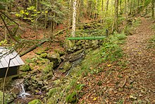
Kostgfall Gorge
The Kostgfall Gorge (also Kostgefäll Gorge ) is located in the southern Central Black Forest (also the northern Black Forest ) in the area of the municipality of Simonswald ( Emmendingen district ).
Characteristic
The Haslach Simonswälder stream falls below the upper valley Kostgefäll in a ravine-like V-shaped valley with 25 percent gradient a well 200 meters deep valley level down into the lower portion of the valley Haslach Simon forest . In the Altsimonswald the brook flows into the Wilde Gutach . The gorge begins with a waterfall about 10 meters high and up to 5 meters wide . In the further course the brook forms several falls about 2 meters high in the blocked brook bed. In the north, the 40-meter-high cliffs of the Gällefelsen rise from the block-rich ravine slopes .
Geography and geology
Unlike the rest of the Simonswälder Valley , the Haslachsimonswälder valley, which is roughly 500 meters deep , is less characterized by paragneiss , but rather by coarse, weathered orthogneiss tending to form cliffs . The steep step cut by the Kostgfall Gorge is more resistant due to a traversing quartz reef (partially formed as a ribbon agate ), which has formed along a tectonic fault and has minor mineralization . In addition, very tough amphibolites and rhyolites are switched on here. The high valley above with valley meadows and a few individual farms shows pronounced glacial forms, below the gorge fluvial erosion forms dominate . The high steep slopes, rich in rubble, are shaded by typical ash-maple ravine forest and on the sunny side by mixed sloping forests with a larger proportion of oak. The less steep slopes are used as pasture fields (cattle pastures). The diet is also a mosaic of grass grass , moist or subalpine tall herbaceous vegetation , juniper heaths and species-rich mountain meadows. The area is therefore under nature protection (446 hectares).
tourism
The somewhat remote gorge is mainly visited as a climbing destination because of the sloping rocks (around 40 routes on three climbing rocks, difficulty levels 3+ to 9−, closed in spring when birds brood). Apart from the upper waterfall, the actual gorge is only of limited tourist interest due to a pipeline of a small hydroelectric power plant that is elevated in the middle of the stream . The gorge is hiked as an ascent to Rohrhardsberg and in combination with the rock ridges and ridges flanking the valley on both sides, especially on the Schultiskopf . It is also sought out by mineral collectors (for example because of quartz and hematite drusen ). Apartments and guest rooms have been set up on many farms in the vicinity. There is parking a few hundred meters below the gorge (hiking parking lot).
In the vicinity of the Kostgefällschlucht there are other hiking destinations such as the chapel on the Hörnleberg , the Rohrhardsberg, the rock ridge with the Schultiskopf and Obereck or the Martinskapelle .
Sources and web links
- Map of the vegetation types of the diet (PDF file; 1.42 MB)
- Geotope description Gorge in the sloping rocks
Coordinates: 48 ° 7 '11.4 " N , 8 ° 5' 44.3" E


