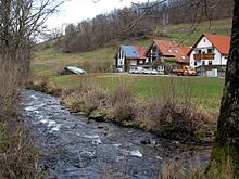
Krummbach (Dreisam)
|
Krummbach Zastlerbach, Osterbach |
||
|
The middle Zastlertal |
||
| Data | ||
| Water code | DE : 2338832 | |
| location |
Black Forest
|
|
| River system | Rhine | |
| Drain over | Dreisam → Elz → Rhine → North Sea | |
| source | In the Zastler Loch on Feldberg 47 ° 52 ′ 27 ″ N , 8 ° 0 ′ 52 ″ E |
|
| Source height | approx. 1445 m above sea level NN | |
| muzzle | in the Dreisam coordinates: 47 ° 58 ′ 48 " N , 7 ° 55 ′ 5" E 47 ° 58 ′ 48 " N , 7 ° 55 ′ 5" E |
|
| Mouth height | approx. 329 m above sea level NN | |
| Height difference | approx. 1116 m | |
| Bottom slope | approx. 66 ‰ | |
| length | 16.9 km | |
| Catchment area | 30.99 km² | |
| Discharge at the Zastler A Eo gauge : 17.8 km² |
NNQ MNQ 1954–2003 MQ 1954–2003 Mq 1954–2003 MHQ 1954–2003 HHQ (1991) |
70 l / s 130 l / s 630 l / s 35.4 l / (s km²) 6.88 m³ / s 24.37 m³ / s |
| Discharge at the A Eo estuary : 30.99 km² |
MNQ MQ Mq MHQ |
160 l / s 840 l / s 27.1 l / (s km²) 9.54 m³ / s |
| Left tributaries | Stollenbach | |
| Right tributaries | Weilersbächle | |
| Communities | Oberried , Kirchzarten | |
The Krummbach is an almost 17 km long left tributary of the Dreisam in the southern Black Forest east of Freiburg im Breisgau in Baden-Württemberg . Its upper course is better known as Zastlerbach , its middle section is also called Osterbach .
Course and natural space

The Zastlerbach arises from numerous source channels of the Zastler Loch , the highest outside Alpine cirque in Germany. In the Karboden at the Zastler Hütte , small swamp areas and round bumps alternate; some of these show glacier scrapes from the Würm glaciation . The stream is fed by the meltwater from the cornices on the steep Osterrain of the Feldberg summit until August .
The Zastlerbach then flows through a steeply sloping trough valley , initially divided by valley steps , which initially runs northwards and then extends in a northwesterly direction. At the lowermost stage is found at the bottom of a formed after the melting of the valley glacier würmkaltzeitlichen block the so-called rock fall and pile Zastler ice holes . Even in summer, heavier, cold air collects under the blocks, and ice can form, often by the end of July, with the added evaporative cold when exiting the stockpile base. They are known by the locals as natural cold stores. Between the Toten Mann ( 1321.7 m above sea level ) and the Hinterwaldkopf ( 1199.2 m above sea level ), the Zastlertal is cut around 600 meters deep into dense igneous and metamorphic rocks ( granite and anatexite ).
As Osterbach, the lower course follows the eastern edge of the Brugga valley , which is broad- bottomed here and which merges into the Zartener basin as Schlempenfeld . There the brook flows into the Dreisam as Krummbach a few hundred meters above the Brugga, which runs parallel to the southwest. Here it carries around 0.84 m³ / s of water on average.
Cultural landscape
The Trogtal offers space for a series of individual farms, which together form the village of Zastler . It belongs to the municipality of Oberried , the center of which is in the Bruggatal.
The valley floor falls at Oberried across the stream bed to the left to the Brugga; nevertheless the Zastlerbach flows as Osterbach following the eastern edge of the valley to Kirchzarten. It is believed that he walks in the bed of the Kirchzartener Floss , a raft canal for transporting wood from the Zastlertal to Freiburg , which was built in the 16th century . In the former channels of the Zastlerbach, small streams now flow to the Brugga.
Below Kirchzarten, the stream, now called Krummbach , runs again in a natural channel that is not sunk very deeply into the large alluvial fans. Here the left branch of the Hagenbach branches off for a kilometer and touches an old ring wall. The Krummbach was rerouted in the area of the newly traversed B 31 at an acute angle . Finally, just before the confluence with the Dreisam, it crosses a golf course.
Individual evidence
- ↑ a b Digital topographic map
- ↑ a b LUBW data and map service
- ↑ Jens Didszun: Experimental studies on the scale dependency of the runoff formation (PDF file; 3.90 MB). Freiburger Schriften zur Hydrologie 19, 2004, pp. 1–221
- ↑ LUBW: Abfluss-BW - regionalized discharge parameters for Baden-Württemberg, water nodes HQ and MQ / MNQ ( Memento of the original from December 28, 2017 in the Internet Archive ) Info: The archive link was automatically inserted and not yet checked. Please check the original and archive link according to the instructions and then remove this notice. (accessed on October 31, 2016)
- ↑ Leisure tips and festivals (TICKET): Zastlertal near Oberried: Icy pleasure - badische-zeitung.de. Retrieved August 7, 2015 .
- ↑ Map services of the Federal Agency for Nature Conservation ( information )


