Hinterwaldkopf
| Hinterwaldkopf | ||
|---|---|---|
|
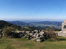
The Hinterwaldkopf above the upper Zastlertal |
||
| height | 1199.2 m above sea level NHN | |
| location | Baden-Wuerttemberg , Germany | |
| Mountains | Black Forest | |
| Coordinates | 47 ° 55 '8 " N , 8 ° 1' 0" E | |
|
|
||
The Hinterwaldkopf is 1199.2 m above sea level. NHN high mountain in the southern Black Forest . It is located in the southeastern catchment area of the Dreisam, east of Freiburg im Breisgau between Kirchzarten and Hinterzarten . It is bounded by the Höllental in the north and the Zastlertal in the south . Nearby villages are Kirchzarten, Oberried (Breisgau) , Falkensteig (zu Buchenbach ) and Hinterzarten.
The characteristic contour of the Hinterwaldkopf is a landmark of the Dreisamtal . Its open summit area offers a view over it to the Kandel . A hiking trail run by the Black Forest Association leads over the mountain.
Web links
Commons : Hinterwaldkopf - collection of images, videos and audio files


