
Bundesstrasse 31
| Bundesstrasse 31 in Germany | |||||||||||||||||||||||||||||||||||||||||||||||||||||||||||||||||||||||||||||||||||||||||||||||||||||||||||||||||||||||||||||||||||||||||||||||||||||||||||||||||||||||||||||||||||||||||||||||||||||||||||||||||||||||||||||||||||||||||||||||||||||||||||||||||||||||||||||||||||||||||||||||||||||||||||||||||||||||||||||||||||||||||||||||||||||||||||||||||||||||||||||||||||||||||||||||||||||||||||||||||||||||||||||||||||||||||||||||||||||||||||||||||||||||||||||||||||||||||||||||||||||||||||||||||||||||||||||||||||||||||||||||||||||||||||||||||||||||||||||||||||||

|
|||||||||||||||||||||||||||||||||||||||||||||||||||||||||||||||||||||||||||||||||||||||||||||||||||||||||||||||||||||||||||||||||||||||||||||||||||||||||||||||||||||||||||||||||||||||||||||||||||||||||||||||||||||||||||||||||||||||||||||||||||||||||||||||||||||||||||||||||||||||||||||||||||||||||||||||||||||||||||||||||||||||||||||||||||||||||||||||||||||||||||||||||||||||||||||||||||||||||||||||||||||||||||||||||||||||||||||||||||||||||||||||||||||||||||||||||||||||||||||||||||||||||||||||||||||||||||||||||||||||||||||||||||||||||||||||||||||||||||||||||||||
| |
|||||||||||||||||||||||||||||||||||||||||||||||||||||||||||||||||||||||||||||||||||||||||||||||||||||||||||||||||||||||||||||||||||||||||||||||||||||||||||||||||||||||||||||||||||||||||||||||||||||||||||||||||||||||||||||||||||||||||||||||||||||||||||||||||||||||||||||||||||||||||||||||||||||||||||||||||||||||||||||||||||||||||||||||||||||||||||||||||||||||||||||||||||||||||||||||||||||||||||||||||||||||||||||||||||||||||||||||||||||||||||||||||||||||||||||||||||||||||||||||||||||||||||||||||||||||||||||||||||||||||||||||||||||||||||||||||||||||||||||||||||||
| map | |||||||||||||||||||||||||||||||||||||||||||||||||||||||||||||||||||||||||||||||||||||||||||||||||||||||||||||||||||||||||||||||||||||||||||||||||||||||||||||||||||||||||||||||||||||||||||||||||||||||||||||||||||||||||||||||||||||||||||||||||||||||||||||||||||||||||||||||||||||||||||||||||||||||||||||||||||||||||||||||||||||||||||||||||||||||||||||||||||||||||||||||||||||||||||||||||||||||||||||||||||||||||||||||||||||||||||||||||||||||||||||||||||||||||||||||||||||||||||||||||||||||||||||||||||||||||||||||||||||||||||||||||||||||||||||||||||||||||||||||||||||
 |
|||||||||||||||||||||||||||||||||||||||||||||||||||||||||||||||||||||||||||||||||||||||||||||||||||||||||||||||||||||||||||||||||||||||||||||||||||||||||||||||||||||||||||||||||||||||||||||||||||||||||||||||||||||||||||||||||||||||||||||||||||||||||||||||||||||||||||||||||||||||||||||||||||||||||||||||||||||||||||||||||||||||||||||||||||||||||||||||||||||||||||||||||||||||||||||||||||||||||||||||||||||||||||||||||||||||||||||||||||||||||||||||||||||||||||||||||||||||||||||||||||||||||||||||||||||||||||||||||||||||||||||||||||||||||||||||||||||||||||||||||||||
| Basic data | |||||||||||||||||||||||||||||||||||||||||||||||||||||||||||||||||||||||||||||||||||||||||||||||||||||||||||||||||||||||||||||||||||||||||||||||||||||||||||||||||||||||||||||||||||||||||||||||||||||||||||||||||||||||||||||||||||||||||||||||||||||||||||||||||||||||||||||||||||||||||||||||||||||||||||||||||||||||||||||||||||||||||||||||||||||||||||||||||||||||||||||||||||||||||||||||||||||||||||||||||||||||||||||||||||||||||||||||||||||||||||||||||||||||||||||||||||||||||||||||||||||||||||||||||||||||||||||||||||||||||||||||||||||||||||||||||||||||||||||||||||||
| Operator: |
|
||||||||||||||||||||||||||||||||||||||||||||||||||||||||||||||||||||||||||||||||||||||||||||||||||||||||||||||||||||||||||||||||||||||||||||||||||||||||||||||||||||||||||||||||||||||||||||||||||||||||||||||||||||||||||||||||||||||||||||||||||||||||||||||||||||||||||||||||||||||||||||||||||||||||||||||||||||||||||||||||||||||||||||||||||||||||||||||||||||||||||||||||||||||||||||||||||||||||||||||||||||||||||||||||||||||||||||||||||||||||||||||||||||||||||||||||||||||||||||||||||||||||||||||||||||||||||||||||||||||||||||||||||||||||||||||||||||||||||||||||||||
| Start of the street: |
Breisach ( 48 ° 1 ′ N , 7 ° 35 ′ E ) |
||||||||||||||||||||||||||||||||||||||||||||||||||||||||||||||||||||||||||||||||||||||||||||||||||||||||||||||||||||||||||||||||||||||||||||||||||||||||||||||||||||||||||||||||||||||||||||||||||||||||||||||||||||||||||||||||||||||||||||||||||||||||||||||||||||||||||||||||||||||||||||||||||||||||||||||||||||||||||||||||||||||||||||||||||||||||||||||||||||||||||||||||||||||||||||||||||||||||||||||||||||||||||||||||||||||||||||||||||||||||||||||||||||||||||||||||||||||||||||||||||||||||||||||||||||||||||||||||||||||||||||||||||||||||||||||||||||||||||||||||||||
| End of street: |
Weißensberg ( 47 ° 35 ′ N , 9 ° 44 ′ E ) |
||||||||||||||||||||||||||||||||||||||||||||||||||||||||||||||||||||||||||||||||||||||||||||||||||||||||||||||||||||||||||||||||||||||||||||||||||||||||||||||||||||||||||||||||||||||||||||||||||||||||||||||||||||||||||||||||||||||||||||||||||||||||||||||||||||||||||||||||||||||||||||||||||||||||||||||||||||||||||||||||||||||||||||||||||||||||||||||||||||||||||||||||||||||||||||||||||||||||||||||||||||||||||||||||||||||||||||||||||||||||||||||||||||||||||||||||||||||||||||||||||||||||||||||||||||||||||||||||||||||||||||||||||||||||||||||||||||||||||||||||||||
| Overall length: | approx. 200 km | ||||||||||||||||||||||||||||||||||||||||||||||||||||||||||||||||||||||||||||||||||||||||||||||||||||||||||||||||||||||||||||||||||||||||||||||||||||||||||||||||||||||||||||||||||||||||||||||||||||||||||||||||||||||||||||||||||||||||||||||||||||||||||||||||||||||||||||||||||||||||||||||||||||||||||||||||||||||||||||||||||||||||||||||||||||||||||||||||||||||||||||||||||||||||||||||||||||||||||||||||||||||||||||||||||||||||||||||||||||||||||||||||||||||||||||||||||||||||||||||||||||||||||||||||||||||||||||||||||||||||||||||||||||||||||||||||||||||||||||||||||||
|
State : |
|||||||||||||||||||||||||||||||||||||||||||||||||||||||||||||||||||||||||||||||||||||||||||||||||||||||||||||||||||||||||||||||||||||||||||||||||||||||||||||||||||||||||||||||||||||||||||||||||||||||||||||||||||||||||||||||||||||||||||||||||||||||||||||||||||||||||||||||||||||||||||||||||||||||||||||||||||||||||||||||||||||||||||||||||||||||||||||||||||||||||||||||||||||||||||||||||||||||||||||||||||||||||||||||||||||||||||||||||||||||||||||||||||||||||||||||||||||||||||||||||||||||||||||||||||||||||||||||||||||||||||||||||||||||||||||||||||||||||||||||||||||
| Development condition: | two-lane, three-lane, four-lane | ||||||||||||||||||||||||||||||||||||||||||||||||||||||||||||||||||||||||||||||||||||||||||||||||||||||||||||||||||||||||||||||||||||||||||||||||||||||||||||||||||||||||||||||||||||||||||||||||||||||||||||||||||||||||||||||||||||||||||||||||||||||||||||||||||||||||||||||||||||||||||||||||||||||||||||||||||||||||||||||||||||||||||||||||||||||||||||||||||||||||||||||||||||||||||||||||||||||||||||||||||||||||||||||||||||||||||||||||||||||||||||||||||||||||||||||||||||||||||||||||||||||||||||||||||||||||||||||||||||||||||||||||||||||||||||||||||||||||||||||||||||
_02.jpg) |
|||||||||||||||||||||||||||||||||||||||||||||||||||||||||||||||||||||||||||||||||||||||||||||||||||||||||||||||||||||||||||||||||||||||||||||||||||||||||||||||||||||||||||||||||||||||||||||||||||||||||||||||||||||||||||||||||||||||||||||||||||||||||||||||||||||||||||||||||||||||||||||||||||||||||||||||||||||||||||||||||||||||||||||||||||||||||||||||||||||||||||||||||||||||||||||||||||||||||||||||||||||||||||||||||||||||||||||||||||||||||||||||||||||||||||||||||||||||||||||||||||||||||||||||||||||||||||||||||||||||||||||||||||||||||||||||||||||||||||||||||||||
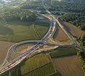
| Bundesstrasse 31 near Freiburg | |||||||||||||||||||||||||||||||||||||||||||||||||||||||||||||||||||||||||||||||||||||||||||||||||||||||||||||||||||||||||||||||||||||||||||||||||||||||||||||||||||||||||||||||||||||||||||||||||||||||||||||||||||||||||||||||||||||||||||||||||||||||||||||||||||||||||||||||||||||||||||||||||||||||||||||||||||||||||||||||||||||||||||||||||||||||||||||||||||||||||||||||||||||||||||||||||||||||||||||||||||||||||||||||||||||||||||||||||||||||||||||||||||||||||||||||||||||||||||||||||||||||||||||||||||||||||||||||||||||||||||||||||||||||||||||||||||||||||||||||||||||
|
Course of the road
|
|||||||||||||||||||||||||||||||||||||||||||||||||||||||||||||||||||||||||||||||||||||||||||||||||||||||||||||||||||||||||||||||||||||||||||||||||||||||||||||||||||||||||||||||||||||||||||||||||||||||||||||||||||||||||||||||||||||||||||||||||||||||||||||||||||||||||||||||||||||||||||||||||||||||||||||||||||||||||||||||||||||||||||||||||||||||||||||||||||||||||||||||||||||||||||||||||||||||||||||||||||||||||||||||||||||||||||||||||||||||||||||||||||||||||||||||||||||||||||||||||||||||||||||||||||||||||||||||||||||||||||||||||||||||||||||||||||||||||||||||||||||
The federal highway 31 (abbreviation: B 31 ) is a federal highway in the south of Germany running in an east-west direction . It runs from Breisach am Rhein on the border with France to the Sigmarszell junction on the federal motorway 96 (A 96) near Lindau (Lake Constance) . Between the transition from the federal motorway 98 (A 98) to the B 31 at the Stockach -Ost junction and the Sigmarszell junction on the A 96, it is a section of the E 54 Paris - Munich European route .
course
Important places on the B 31 and connections to other highways:
- Breisach am Rhein ( federal border D 415 - until 2006 N 415 )
- Freiburg im Breisgau ( A 5 , B 3 )
- Kirchzarten
- Buchenbach
- Hinterzarten ( B 500 )
- Titisee-Neustadt ( B 317 )
- Löffingen (two petrol stations directly on the B 31, Black Forest Park, Wutach Gorge)
- Hüfingen ( B 27 )
- Donaueschingen ( B 33 )
- Geisingen ( A 81 , B 311 )
- Immendingen ( Höwenegg volcanic crater and Danube infiltration , B 311 )
- Stockach ( A 98 , B 14 , B 313 )
- Bodman-Ludwigshafen ( B 34 )
- Überlingen
- Uhldingen-Mühlhofen
- Meersburg ( B 33 )
- Hagnau
- Immenstaad
- Friedrichshafen ( B 30 )
- Kressbronn am Bodensee ( B 467 )
- Weißensberg ( B 12 )
- Sigmarszell ( A 96 , B 308 )
- Lindau (Lake Constance)
State of development
The development of the B 31 is structured as follows:
| section | Stripes | Dividing strip | length | comment |
|---|---|---|---|---|
|
Breisach am Rhein - AS Bad Krozingen |
2 | No | 11 km | |
|
|
2 | No | 3.5 km | |
|
|
4th | Yes | 3 km | Motorway-like , truck toll is mandatory |
| Freiburg Basler Landstrasse - L 133 Freiburg Schwarzwaldstrasse | 4.5 km | urban | ||
| L 133 Freiburg Black Forest Road - L 126 AS Kirchzarten | 7 km | Motorway-like, truck toll is mandatory | ||
| L 126 AS Kirchzarten - L 128 AS Buchenbach | 3 | No | 3 km | largely free of partial plans |
| L 128 AS Buchenbach - Höllental | 2 | 4 km | ||
| Höllental - Hirschsprung | 3 | 2 km | largely free of partial plans | |
| Hirschsprung - Höllsteig | 4th | 4 km | ||
| Höllsteig - Hinterzarten |
3 | 3 km | ||
|
|
2 | 6 km | largely free of partial plans | |
|
|
3 | 10 km | Partial plan free, except for the intersection with the L 182 | |
| L 182 Rötenbach - Döggingen tunnel | 2 | 11.5 km | ||
| Döggingen - Hüfingen tunnel |
3 | 6.5 km | ||
|
|
2 | 13.5 km | ||
|
|
2 | No | 70 km | From Friedrichshafen mostly free of partial plans |
history
Bundesstraße 31 has its origins in old Roman roads connecting fortresses on the Rhine (Breisach) with the Roman military road east of the Black Forest. It emerged from Reichsstrasse 31 (1934) in 1949 .
After Austria was " annexed " to the Third Reich (1938), the route from Lindau to Austria was extended. First it ran south from Bregenz to Feldkirch . Here the R 31a branched off to the Liechtenstein border at Tisis .
The road continued via Alpe Rauz am Arlberg ( R 17 ), Landeck (Tyrol) ( R 24 ), Imst (R 24), Telfs ( R 309 ) and Zirl ( R 2 ) to Innsbruck (R 2). From here it went on via Jenbach (R 318), Wörgl ( R 15 ), Ellmau (R 15a) and Lofer (R 21) back to the Bavarian border. Via Schneizlreuth (R 305) and Bad Reichenhall (R 20) the route reached the Austrian border again. The last section went on Salzburg , Vöcklabruck , Lambach (R 339/ 340 ) and Wels (R 332) to Linz .
During the Second World War , the western part was extended into the occupied Alsace , which was annexed to the German Empire . The route ran via Neubreisach (R 9) and Colmar (R 38) to the gorge pass . As the war continued, the line was extended to Gérardmer . The section to Colmar is part of the N 415 (today D 415) and Colmar-Gérardmer is part of the N 417 (today D 417).
On February 6, 1949, a serious bus accident occurred between Döggingen and Unadingen near the old Gauchach bridge in the so-called Dögginger Loch . Due to a brake failure, a bus filled with skiers from the Radolfzell area fell down an embankment in the Gauchach. 22 people lost their lives, and numerous others suffered injuries, some of them serious. A memorial stone near the accident site today commemorates the accident.
Previous routes and names
Originally the R 31 and B 31 ran differently in the following sections:
- West of Freiburg: through the towns of Oberrimsingen , Munzingen and Tiengen ; Now guided tour to the Bad Krozingen junction (former section of the state road 120) and gap to the Freiburg Süd junction of the (A 5) federal motorway 5 (original route downgraded as district roads 4999 and 9864)
- Donaueschingen area: Until the construction of today's B 27 east of Donaueschingen in the 1970s, the B 31 and the B 27 formed an intersection in the city center. Today's direct route from Geisingen south of Pfohren to today's junction was not built until the 1980s.
- Southeast from Donaueschingen to Lake Constance: between the places Geisingen and Stockach; Now guided tour to the Geisingen junction (there transition to the B 311 ) and the gap to the junction with the B 313 at the Stockach-Ost junction of the A 98 (original route downgraded as a section of state roads 191 and 194)
- In the Überlingen area: through Überlingen, Nussdorf, Unteruhldingen, Meersburg
- In the Lindau area: through Kressbronn, Lindau ( R 12 ) and Lindau-Zech to the German-Austrian border ; now guided tour north of Lindau to the Sigmarszell junction of the A 96 (there transition to the B 308 ).
Further expansion
To the west of Freiburg city center, the Mitte motorway feeder road was also built as the B 31a along the Dreisam to the Freiburg Mitte motorway junction without the intersection of the A 5, and the Umkirch bypass on the other side of the motorway as the first section of a completely new route (the B 31 West ) towards Breisach. The entire work in the section Umkirch to Gottenheim should be completed by spring 2012, but continued until the release on September 7, 2012. The planning for the extension from Gottenheim to Breisach was stopped by the state government in 2011. Planning was resumed in 2015, but environmentalists and the Freiburg Regional Council are arguing at the beginning of 2017 due to new reports.
Furthermore, the B 31 has been expanded in many areas in recent years by bypasses, so at the turn of the millennium traffic in the east of Freiburg was shifted from Littenweiler , Ebnet and Zarten to a newly built, four-lane motorized road . The Kappler Tunnel and the Schützenalleetunnel were built for this purpose. At the same time was in Döggingen the combination of Gauchachtalbrücke Döggingen about Dögginger hole and tunnel Döggingen built. In addition, areas near Löffingen and Rötenbach were expanded to three lanes (2 + 1). Such an expansion also took place between the connection of the B 317 at Titisee and Neustadt Ost, so that the aforementioned area of Titisee-Neustadt is now also classified as a motor vehicle. In Friedrichshafen, an intersection-free route was implemented from the eastern city limits in the suburb of Kitzenwiese to the ZF plant in the 1990s. The section to the west to the Riedlewald was released on December 7, 2001. On November 24, 2014, the ground-breaking ceremony took place to close the last section of the Friedrichshafen bypass to the western city limits between the Fischbach district and the neighboring municipality of Immenstaad to the west. This more than 7 kilometers long section is to be opened to traffic in 2020. There is an aerial photo of the entire scope of the project. The federal government is contributing 100 million euros for the construction project.
In the meantime, the expansion from Immenstaad to Überlingen is in the planning stage, with various route variants near and far from the lake being discussed controversially. In the area north of Überlingen, a section of the B31n, built in the early 1980s, has already been put into operation in the area of the easternmost section. An expansion is planned for the area between Immenstaad and Meersburg, but this is met with protests. Regio TV Bodensee has also created a video "Info evening" for this expansion. Furthermore, the regional council of Tübingen operates its own information page.
The continuation on the Alsatian side has also been expanded in recent years to the Rhine Valley motorway A 35 there , but downgraded from a French national road while retaining the number as Departementsstraße 415 . This reallocation took place in 2006. All these expansion measures (also as a replacement for a southern Black Forest motorway originally planned with the project name A 86 ) led to a sharp increase in transit traffic, so that especially in Freiburg and in the town of Falkensteig, the population was tunneling under the particular locations, as a bypass road is difficult and expensive due to the topography. In addition, the tubes of the Dögginger Tunnel (both two-lane) are currently only approached via one bridge, two two-lane bridges were planned, but so far there was no money. The Donaueschingen - Löffingen tunnel can only be used in one lane, as it is too dangerous for both lanes to merge in the tunnel. In the meantime, the construction of the second bridge can be expected in 2019 [obsolete] , the construction time should be 3 years .
After a rock fall in Höllental (between Freiburg and Hinterzarten) in 2009, rock protection measures were carried out in this area at the end of September / beginning of October 2010. The B 31 was completely closed to traffic and largely diverted via the Glottertal and the Thurner . A specialist company removed several cubic meters of rock as well as trees and bushes. The cost of the work amounted to around 600,000 euros. Further rock securing measures that impaired traffic were initially completed in October 2015. In the summer of 2020, rock securing work was carried out again, a new scree fence was installed at the Hirschsprung and the roadway in Falkensteig was renewed, which led to the B 31 being closed for almost two weeks. This attracted walkers and cyclists.
After the completion of the Freiburg city tunnel , which is in the planning stage , the B 31 will be upgraded to the 860 federal motorway between the end of the expansion at Kirchzarten and the end of the expansion at Umkirch . The Freiburg-Mitte junction of the A 5 , already designed as a clover leaf , will then become the Freiburg motorway junction . In one presented in February 2020 by the Freiburg Government Bureau overview map for further expansion planning the route between Freiburg and Donaueschingen a fourth tunnel beside Freiburg City Tunnel and the Falkenstein- and Hirschsprung tunnel is shown, that of the Löffeltalkurve when Imbery in Höllentalbahn up to Hinterzarten up to the level of the former inn Lafette should be enough.
Furthermore, an expansion for the 10.5 km long Kressbronn-Lindau route was or is being discussed, reports the Schwäbische Zeitung . However, according to a report from 2016, this plan seems "more uncertain than ever". A four-lane expansion was or is under discussion, because the volume of traffic is enormous.
Bundesstrasse 31n
The federal road 31n (abbreviation B 31n ) is the official name of road sections that will replace the old B 31 as bypass roads after completion . Between Stockach and Überlingen it was created to complement the old route that runs close to Lake Constance. It forms the extension of the A 98. There are currently no exits on the B 31n between Stockach-Ost and Überlingen-Nord. The old road is still classified as B31.
tourism
Through its course in the Upper Black Forest, the B 31 opens up classic holiday areas around Hinterzarten, Titisee and Neustadt. It also provides access to the Feldberg area. It also links the Black Forest holiday region with Lake Constance. The passage through the Höllental with its deer monument is a typical holiday route, this is underlined by the naming of rest areas with Alemannic names in order to bring the linguistic peculiarities of the region closer to the guest. One example is "Verschnuufeckli" = place to breathe easy after a winding route. Since the 1990s at the latest, negative effects on tourism have been discussed in connection with the further expansion of the road. Against the background of the fact that the traffic density on the B 31 near Hinterzarten increased by 19.4% between 2010 and 2018, demands were made in the local council in 2019 to limit these effects.
See also
literature
- Hans-Otto Mühleisen (Ed.): B 31 East: a street towards Freiburg . Jos-Fritz-Verlag, Freiburg [Breisgau] 2002, ISBN 978-3-928013-22-2 .
- Daniel Schneider: The development history of the B 31 between Freiburg im Breisgau and Breisach am Rhein , in: Walter Laub / Bernhard Kenk / Daniel Schneider: The B 31-West ... in and around Umkirch. Umkirch 2007, OCLC 315875638 , pp. 7-20.
- Carsten Friedrich Vogelpohl: B 31-Ost: the disputes over east-west traffic in Freiburg i. Br . Donzelli-Kluckert, Bremgarten 2008, ISBN 978-3-933284-19-8 .
Web links
- Detailed route description of the Black Forest autobahn, which was previously planned as Bundesautobahn 86
- Detailed route description of the Lake Constance autobahn, which was previously planned as federal autobahn 98
- "Bodensee-Autobahn A 98 Singen-Lindau" - visual compilation with history
- "Accidents B 31" dossier compiled by the Badische-Zeitung
- Bavarian traffic accident statistics
- Traffic accident statistics of the police headquarters Swabia South / West
- Detailed route description of the Freiburg central motorway feeder, which was previously planned as federal motorway 860
- www.dreisamufer.de (on the history of the B 31)
- Report on the new construction of the B 31 east

B 31 Falkenstein

B 31 Höllental

Closure of the B 31 for rock protection work at the Hirschsprung

Demands for a tunnel in Falkensteig

Transfer of the B 31 over the K 7777 near Kressbronn
New building B 31 West near Umkirch with motorway connection A 5 Freiburg-Mitte

Route of the later federal highway 31 through the Höllental around 1885

B 31 at the narrowest point of the Höllental at Hirschsprung


Individual evidence
- ↑ Four lanes in the Freiburg area, partially expanded to resemble a motorway; Freiburg – Geisingen and Stockach – Überlingen partially expanded to three lanes and free of intersections
- ^ Carsten Wasow: The federal and former imperial roads in Germany. (No longer available online.) Archived from the original on September 7, 2012 ; Retrieved December 12, 2011 (private website).
- ↑ www.nq-online.de
- ↑ For the history see Daniel Schneider: The history of the development of the B 31 between Freiburg im Breisgau and Breisach am Rhein, pp. 7-20.
- ^ Manfred Frietsch: New ways for pedestrians, cyclists and tractors. In: badische-zeitung.de. Badische Zeitung , January 22, 2011, accessed on December 12, 2011 (newspaper article).
- ↑ Kathrin Blum: District of Breisgau-Hochschwarzwald: Umkirch to Gottenheim: Inauguration of the B31-West: Ceremony with critical tones , Badische Zeitung, September 7, 2012, accessed on March 28, 2013
- ↑ Sebastian Wolfrum: District of Breisgau-Hochschwarzwald: Expansion to Breisach: Conservationists: B 31 West may not be built. Badische Zeitung, January 6, 2017, accessed on January 7, 2017 .
- ↑ Traffic clearance at the Riedleparktunnel - Schwäbische from November 26, 2001 . In: Swabian . ( schwaebische.de [accessed on October 15, 2018]).
- ^ City of Friedrichshafen: B 31 new. Retrieved August 15, 2019 .
- ↑ New B 31 flight, Immenstaad - Friedrichshafen, 06/2018. Retrieved August 15, 2019 .
- ↑ BMVI - Bär: The federal government is investing 100 million euros in the new construction of the B 31 near Friedrichshafen. Retrieved August 15, 2019 .
- ↑ Dossier. Retrieved August 17, 2019 .
- ↑ B31 route: Citizens' initiatives demonstrate on the main road in Hagnau - schwaebische.de. Retrieved August 15, 2019 .
- ↑ Information evening on the expansion of the B31 section Immenstaad - Meersburg | 02/13/2019. Retrieved August 15, 2019 .
- ↑ The plans to expand and rebuild the B 31 continue | B 31 in dialogue. Retrieved August 15, 2019 .
- ↑ The number of vehicles driving through Falkensteig daily on the B31 increased from 17,140 to 21,509 between 2010 and 2018, cf. Traffic development at the permanent counting point B31 Falkensteig. Road traffic control center Baden-Württemberg, April 3, 2019, accessed on November 4, 2019 .
- ↑ The Döggingen tunnel had construction costs of 40.3 million euros, the Gauchachtal bridge Döggingen cost 16.8 million euros.
- ↑ Wulf Rüskamp: Südwest: Second B-31 bridge over the Gauchach until 2021. Badische Zeitung, December 27, 2016, accessed on June 13, 2017 .
- ^ Karl-Heinz and Mirko Zurbonsen: Deer jump without deer. In: suedkurier.de. Südkurier, August 9, 2010, accessed December 12, 2011 (newspaper article).
- ↑ Karl-Heinz Zurbonsen: mountaineers clean the Hell Valley. In: suedkurier.de. Südkurier, September 29, 2010, accessed December 12, 2011 (newspaper article).
- ^ District of Breisgau-Hochschwarzwald: Traffic artery: Security in Höllental has ended after five years - badische-zeitung.de. Retrieved January 1, 2016 .
- ↑ Sebastian Krüger & Markus Donner: The B 31 in Höllental will be closed for two weeks from June 22nd. Badische Zeitung, June 7, 2020, accessed on August 14, 2020 .
- ↑ Max Schuler: Höllental is open earlier than expected. Badische Zeitung, July 4, 2020, accessed on August 14, 2020 .
- ↑ Press release of the City of Freiburg, May 23, 2012 ( Memento of February 24, 2018 in the Internet Archive ) B 31 becomes a motorway with the city tunnel
- ↑ Michael Dörfler: What is being built and planned on the B31 . In: Badische Zeitung, Hochschwarzwald edition . February 1, 2010, p. 29 ( badische-zeitung.de [accessed on May 11, 2020]).
- ↑ Third track - if it does, it will take ... Accessed August 15, 2019 .
- ↑ B 31: Third track is more uncertain than ever. Retrieved August 15, 2019 .
- ↑ A whole region is stuck in traffic. Retrieved August 15, 2019 .
- ↑ The Alemannic names of the rest areas as well as their meaning and the exact location on the B 31 can be viewed on the website of the Freiburg Regional Council
- ↑ Stefanie Röder, Ruggero Schleicher-Tappeser: Possible effects of an expansion of the B 31 on the structural development in the Hinterzarten-Titisee-Neustadt area: preliminary investigation (= EURES discussion paper . Dp17). EURES, Freiburg i. Br 1992, DNB 930470486 , p. 38 ff .
- ↑ See traffic development at the permanent counting point B31 Hinterzarten. Baden-Württemberg Road Traffic Control Center, April 3, 2019, accessed on December 5, 2019 . Heavy goods traffic even increased by 38.8% in this period.
- ↑ Susanne Gilg: "The noise has become unbearable". Hinterzarten and Breitnau want to jointly submit an application to the regional council for a night speed limit on the B31 . In: Badische Zeitung, Hochschwarzwald edition . July 18, 2019, p. 23 ( badische-zeitung.de ).