Green road
The Green Road is a German holiday route through the Black Forest between Breisach am Rhein im Breisgau , Freiburg im Breisgau , Titisee-Neustadt and Donaueschingen .
In a broader sense, borne by the Franco-German friendship, it begins as a cross-border road in France as Route Verte in Contrexéville in the Vosges. It crosses the Rhine at Neuf-Brisach and Breisach.
history
On the route between Contrexéville and Donaueschingen there are 17 French and German towns that are members of the “Association Route Verte / Grüne Straße” based in Colmar . The name of the Green Street is derived from the fir trees in the street. The main initiator of the Green Street, founded in 1960/61, was Joseph Rey (Colmar), fellow campaigners were Willy Boss (Black Forest-Bodensee) and Josef Bueb ( Breisach ).
Well-known cities on the French side
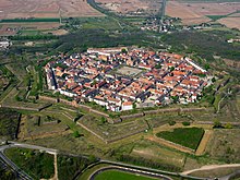
Contrexéville and Vittel are known for their medicinal baths and mineral waters. The famous cheese is at home in the town and valley of Munster (Haut-Rhin) . The medieval towns of Turckheim and Colmar as well as the defense system in the form of an octagonal star in Neuf-Brisach are among other interesting places along the route. The holiday regions of the Vosges and Alsace and the unified Upper Rhine landscape are thereby opened up.
To the southeast through the Black Forest
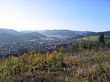
This is followed by Breisach with its location 42 meters above the Rhine, medieval Freiburg at the foot of the Black Forest, the Höllental with the monument to the " Hirschsprungs " and Titisee-Neustadt , which is located on federal highway 31 . The medieval cities of Löffingen and Donaueschingen are also among the member cities of Green Street.
An idea that unites people
The Green Road / Route Verte opens up France and Germany with its state of Baden-Württemberg .
course
![]() Map with all coordinates: OSM | WikiMap
Map with all coordinates: OSM | WikiMap
literature
- ADAC (Hrsg.): Through heaven and hell valley. The Green Road South Black Forest – Lake Constance. In: On the way on Germany's holiday routes, ADAC annual edition 1998/1999, pp. 62–64
- Roland and Karin Bueb: Along the Grünen Straße - On the holiday route from Breisgau to Lake Constance. In: The Badener . Bulletin of the Association of Badeners of Hamburg and Surroundings e. V., April / May 2009, p. 7.
Individual evidence
- ^ Website of the Green Street Community
- ↑ Website of the Green Street Community (de / fr / en)
- ↑ Grüne Straße / Route Verte at www.ferienstrassen.info ( memento of the original dated February 6, 2016 in the Internet Archive ) Info: The archive link was inserted automatically and has not yet been checked. Please check the original and archive link according to the instructions and then remove this notice.


