
Lofer
|
market community Lofer
|
||
|---|---|---|
| coat of arms | Austria map | |
 |
|
|
| Basic data | ||
| Country: | Austria | |
| State : | Salzburg | |
| Political District : | Zell am See | |
| License plate : | ZE | |
| Surface: | 55.67 km² | |
| Coordinates : | 47 ° 35 ' N , 12 ° 42' E | |
| Height : | 626 m above sea level A. | |
| Residents : | 2,059 (January 1, 2020) | |
| Postal code : | 5090 | |
| Area code : | 06588 | |
| Community code : | 5 06 10 | |
| NUTS region | AT322 | |
| UN / LOCODE | AT LOF | |
| Address of the municipal administration: |
Lofer 25 5090 Lofer |
|
| Website: | ||
| politics | ||
| mayor | Norbert Meindl ( ÖVP ) | |
|
Municipal Council : (2019) (17 members) |
||
| Location of Lofer in the Zell am See district | ||
  |
||
 town hall |
||
| Source: Municipal data from Statistics Austria | ||

Lofer is a market town with 2059 inhabitants (as of January 1, 2020) in the Austrian state of Salzburg , in the Pinzgauer Saalachtal.
geography
Lofer is located in the Pinzgau Saalachtal , framed by the mountain ranges of the Loferer and Reither Steinberge , in the north the foothills of the Chiemgau Alps , in the west the Strub Pass .
Lofer is the central place in the Salzburger Saalachtal.
Community structure
The municipality includes the following six localities (as of January 1, 2020):
- Au (181)
- Faistau (54)
- Hall stone (144)
- Lofer (1210)
- Mayrberg (46)
- Scheffsnoth (424)
The community consists of four cadastral communities (area 2016):
- Au (1,766.89 ha)
- Hallenstein (1,115.73 ha)
- Lofer (1,938.51 ha)
- Scheffsnoth (742.61 ha)
Until the end of May 1923, the community belonged to the judicial district of Lofer , then until June 2017 to the judicial district of Saalfelden . On July 1, 2017, she was assigned to the judicial district of Zell am See .
Neighboring communities
Neighboring communities in the valley are Unken after the Kniepass , and Sankt Martin bei Lofer , Weißbach bei Lofer to the south.
history
The place is mentioned in documents as early as the 15th century. Nevertheless, excavations in 1955 showed that the foundations of the first buildings still preserved today were built in the 14th century. Lofer was also an important relay station for horses and their archiepiscopal messengers who brought news from Salzburg to Veneto .
In 1731 the so-called Loferer market fire destroyed the place. After the fire, however, the buildings were rebuilt. The community became known because it served as the backdrop for the movie Agents Die Lonely .
Population development

Culture and sights


- Catholic parish church Lofer Hll. Maria and Leonhard
- oldest plague column in the Salzburg region (1564)
- Fortress Strub : former border fortification from 1809 on the border with Tyrol , which was exposed in 1983/84.
- the Triftsteig through the Teufelsschlucht
- the little church in Au (built as a chapel in 1494; further modifications in 1869, 1720 and 1777)

Lofer, at the foot of the Loferer Steinberge, from Gr. Häuselhorn on the Reither Steinberge

Loferer Steinberge
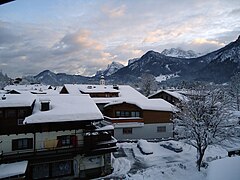
Lofer in winter


Regular events

- Thanksgiving on the first Sunday of October
- Saalachtaler Bladlfest in mid-September
- Market festival in Lofer in mid-July - August
The sex comedy Alpenglüh'n im Dirndlrock was recorded in Lofer in 1974. The place is called "Vögelbrunn" in the film and is located in Bavaria.
Economy and Infrastructure

Lofer is essentially shaped by agriculture and tourism. It has more than 2,500 guest beds. A leisure pool, cycle paths and family-friendly restaurants complete the picture. The Loferer Alm ski and hiking area can be reached from the village, the Steinplatte and Heutal ski areas are nearby.
traffic
Lofer is on the Loferer Straße B 178, which leads from Salzburg over the Kleine Deutsche Eck and on over the Pass Strub to St. Johann in Tirol , in Lofer the Pinzgauer Straße B 311 branches off to Saalfelden and Zell am See .
politics
The community council has a total of 17 members.
- With the municipal council and mayoral elections in Salzburg in 2004, the municipal council had the following distribution: 10 ÖVP, 4 FPÖ, and 3 SPÖ.
- With the municipal council and mayoral elections in Salzburg in 2009 , the municipal council had the following distribution: 11 ÖVP, 3 FPÖ, and 3 SPÖ.
- With the municipal council and mayoral elections in Salzburg 2014 , the municipal council has the following distribution: 10 ÖVP, 5 FPÖ, and 2 SPÖ.
- With the municipal council and mayoral elections in Salzburg in 2019 , the municipal council has the following distribution: 10 ÖVP, 5 FPÖ, and 2 SPÖ.
mayor
- 1959–1974 Josef Färberinger (ÖVP)
- 1974–1998 Rudolf Eder (ÖVP)
- 1999–2004 Kurt Pühringer (ÖVP)
- 2004–2014 Bettina Dürnberger / Bettina Mitterer (ÖVP)
- since 2014 Norbert Meindl (ÖVP)
coat of arms
The blazon of the municipal coat of arms reads:
- "In a shield divided by red and blue, the figure of St. Mary standing on the crescent moon, surrounded by an oval golden nimbus, a crown on her head, the scepter in her right hand and the baby Jesus in her left."
Personalities
- Erich Gebert (1895–1978), economic expert and NSDAP regional economic advisor
- Othmar Schmiderer (* 1954), director
- Rosa Lohfeyer (* 1956), politician (SPÖ) and teacher
- Karin Berger (* 1963), Vice Mayor
- Rudolf Eder (* 1934), former Austrian politician (ÖVP), carpenter and farmer
- Ernst Schilling (1809–1872), doctor and democratic politician
See also
- Former forest office of the Bavarian Saalforsten , now part of the Sankt Martin bei Lofer forestry company of the Bavarian State Forests
Web links
- 50610 - Lofer. Community data, Statistics Austria .
- Community website
- Website of the Salzburger Saalachtal tourist office
Individual evidence
- ↑ Statistics Austria: Population on January 1st, 2020 by locality (area status on January 1st, 2020) , ( CSV )
- ↑ Federal Office for Metrology and Surveying, Regional Information. Reference date December 31, 2016, accessed February 19, 2017
- ↑ Information boards in the city center of Lofer
- ↑ Josef Farbinger . In: Salzburger Nachrichten : Salzburgwiki .
- ↑ Rudolf Eder . In: Salzburger Nachrichten : Salzburgwiki .
- ↑ Kurt Pühringer . In: Salzburger Nachrichten : Salzburgwiki .
- ↑ Bettina Mitterer . In: Salzburger Nachrichten : Salzburgwiki .

Bramberg | Bruck | Served | Fusch | Hollersbach | Kaprun | Krimml | Lend | Leogang | Lofer | Maishofen | Maria Alm | Mittersill | Neukirchen | Niedernsill | Piesendorf | Rauris | Saalbach-Hinterglemm | Saalfelden | St. Martin | Stuhlfelden | Taxenbach | Toads | Uttendorf | Viehhofen | Forest | Weissbach | Zell am See