
Stone slab
| Stone slab | ||
|---|---|---|
 Summit of the Steinplatte from the northwest |
||
| height | 1869 m above sea level A. | |
| location | Salzburg and Tyrol , Austria | |
| Mountains |
Chiemgau Alps ( AVE ) Waidring Alps ( Trimmel ) |
|
| Dominance | 5.3 km → Elferhörndl | |
| Notch height | 873 m ↓ valley bridge | |
| Coordinates | 47 ° 36 '15 " N , 12 ° 34' 48" E | |
|
||
| rock | Oberrhätkalk , Kössen formation | |
| Age of the rock | Upper norium - rhaetium | |
| Development | Gondola Waidring - Steinplatte , toll road flagstone | |

The stone slab is an 1869 m above sea level. A. high mountain range in the Chiemgau Alps in Austria . The border between the federal states of Salzburg and Tyrol runs over the summit . To the south the mountain breaks off into striking rock faces. The gentle north side is accessed by several lifts for skiing and hiking tourism.
The history of the concept and its classification
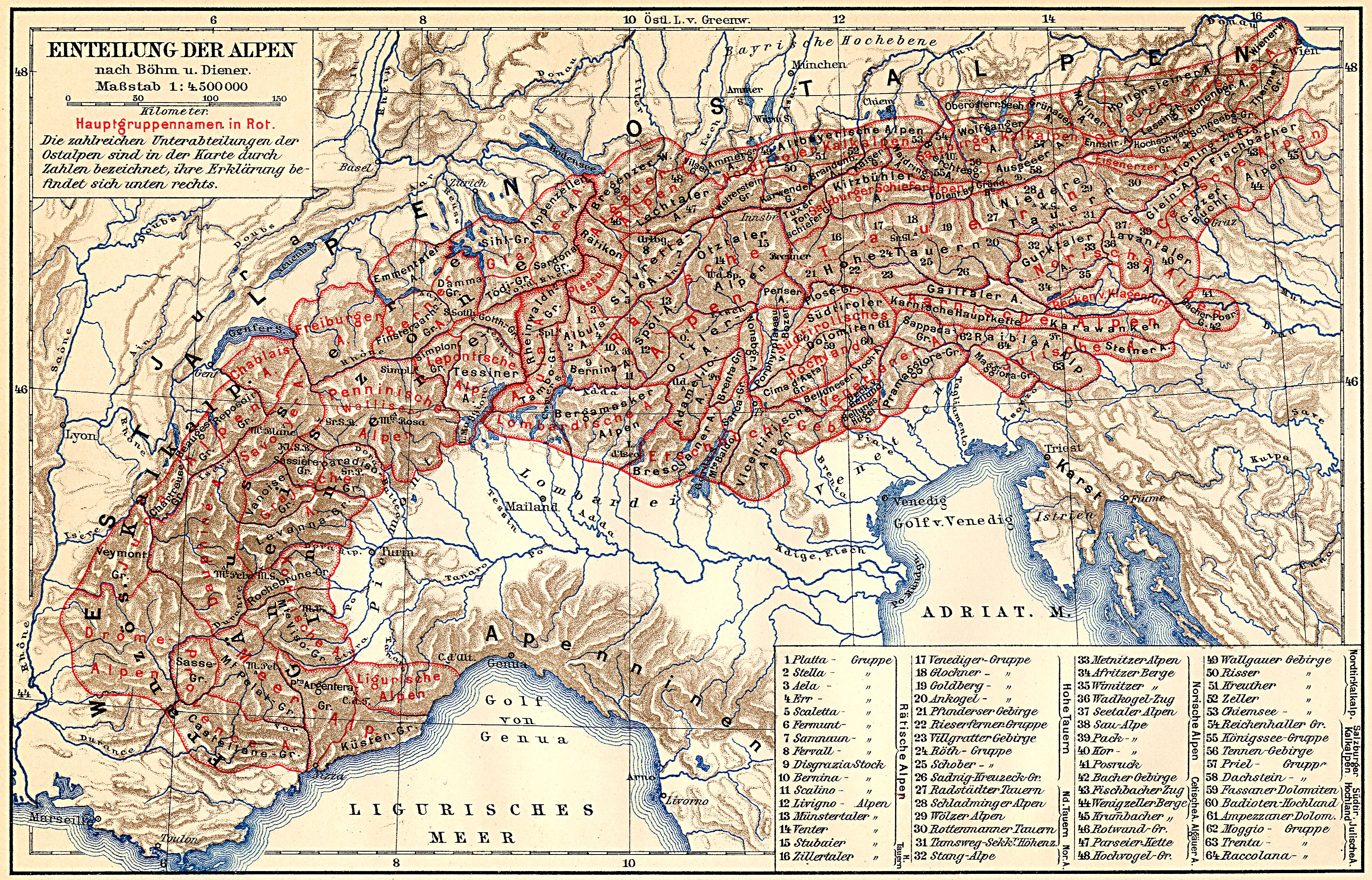
The stone slab floor can be found as early as the 19th century under the name Kammerkargebirge , for example in the division of the Eastern Alps according to Böhm from 1887 (10.1d, also 34d). This designation is largely lost today.
In the mountain range outline of Hubert Trimmel , originally in 1962 published for the Austrian cave directory and in the Austrian Hydrography and Geology is common today, the Group contributes the name stone slab and the number 1322. They will be the Waidringer Alpine expected. According to the Alpine Club division of the Eastern Alps (AVE), it already belongs to the Chiemgau Alps . In the first division, Schwarzlofer - Unkenbach form the southern border of the Chiemgau Alps in the second, the Strub valley .
Boundary and neighboring mountain groups
According to Trimmel, the group is defined as follows:
- in the south Lofer - Loferbach (Strubtal) - Waidring to the Loferer Steinberge (Trimmel 1323)
- towards the southwest borders at Waidring opposite the Kirchbergstock (limestone) (Trimmel 1322)
- in the west Waidring- Hausergasse - Steingaßgraben (Steingaßgrabenbach - Innerwaldbach) to the Steinplatte chapel against the Fellhorn massif (Trimmel 1325)
- in the northeast from there to the Kammerköhralm - Luegbach to the confluence with the Unkenbach at the Schliefbachalm: south of the border triangle Tyrol / Salzburg / Bavaria past the Scheibelberg , which is calculated after Trimmel to the Dürrnbachhorn (Trimmel 1346)
- in the north Schliefbachalm - Unkenbach to the confluence with Oberrain (municipality of Unken) in the Saalach against the Sonntagshorn group
- in the east Saalach Unken - Lofer ( Saalachtal ) to the Reiteralm (Trimmel 1337, part of the Salzburg Alps / Berchtesgaden Alps)
Landscape and peaks

The Steinplatte is located in the municipal area of Unken and Lofer in the Saalachtal , Pinzgau and of Waidring in the Kitzbühel district . The main peak ( 1869 m above sea level ) is on the western edge of the formation. Above the Strubtal , the approximately 1000 meters high sun wall extends to the Grubhörndl ( 1747 m above sea level ) and the Loferer Alm , which stretches towards the Dietrichshorn ( 1542 m above sea level ) over Lofer and Unken. To the north, the stone slab descends in a wooded manner into the Unkenbach valley .
geology
The slab constitutes the southern part of the Unken syncline in which the main dolomite to Tirolikum belongs younger layers of Iuvavikums rest. The Unkenbach as the northern limit of the Steinplatte is roughly in the middle of the syncline.
The southern foot of the sun wall is still made up of main dolomite . The stone slab itself is then represented in Iuvavian rocks, as the main mass from west to east Kössen formation and Oberrhät reef limestone (limestone of the Rhätium ), Ruhpolding formation (radiolarite) and Jura threshold facies (Hierlatzkalkgruppe), Oberalm formation , Schrambach- and Rossfeld formation , in ever younger series. On the eastern edge there are again significantly older, Tyrolean banked Dachstein limestone fragments, which also form the top layer of the Loferer and Leoganger Steinberge, as well as the brightly colored dolomite of the Saalach valley , which is part of the Hallstadt dolomite (both Norium to Rhätium ).
tourism
The Steinplatte skiing and hiking area is part of a network with the Bavarian Winklmoosalm near Reit im Winkl . It can be reached on the road from Waidring to Gasthaus Steinplatte / Bergkapelle (toll road), via the Winklmoosalm, as well as via cable cars from Waidring and, since 2009, from Seegatterl (to Reit im Winkl ) in Bavaria . The ski area covers all levels of difficulty. All lifts can also be used with the St. Johann in Tirol ski pass .
The Loferer Alm ski area is located on the eastern edge near Lofer .
Since August 3, 2008 there has been a primeval adventure park for summer tourism on the Steinplatte, the Triassic Park Steinplatte . The 800,000 euro project was intended to put Europe's only primeval sea, the Tethys Sea or its later regression bay, the Paratethys , in the right light and at the same time also meet a scientific claim, which was still doubted by critics of the project at the time. With the Triassic Park they only feared a new, primeval Disney fantasy world. Part of the facility is a viewing platform at a height of 1600 m , which hovers at the top almost 70 meters above the abyss.
The crossing Lofer / Saalachtal - Steinplatte - Fellhorn - Lofer / Kössen is a variant of the Austrian long-distance hiking trail 01, the Northern Alpine Trail and the European long-distance hiking trail E4 (the main route crosses the Loferer Steinberge and climbs via Waidring to the Steinplattenhaus).
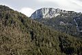
photos
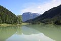
View from the Pillersee to the Steinplatte

Waidring with stone slab
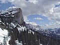
Steinplatte, next to it the Loferer Steinberge
December with little snow

On the plateau
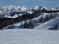
Ski Area


Web links
- [ https://www.steinplatte.tirol/ Homepage] (Austria)
Individual evidence
-
↑ August von Böhm : Classification of the Eastern Alps . In: A. Penck (Ed.): Geographische Abhandlungen . tape 1 . Eduard Hölzel, Vienna 1887 (1 multicolored map (1: 1,000,000)). Revised Carl Diener : The Mountain Construction of the Western Alps . Tempsky / Freytag, Prague 1891.
Used in the Alps, for example . In: Meyers Großes Konversations-Lexikon . 6th edition. tape
1 . Leipzig 1905, [2]. Geographical division of the Alps. [Eastern Alps.] 11) The Salzburg Limestone Alps. , S. 361–369 [365] ( zeno.org - classification according to Böhm and Diener, map 1: 4,500,000 ). Salzburg . ibid. volume 17 , 1909, [1]., Pp. 499-500 [499] ( zeno.org ). - ↑ cf. also postcard Winklmoos Loferer Steinberge Kammerkar Scheibelberg , Gebirgsverlag Peter Triem, Munich. Item number: 12050855. (Fig. Jpg) Sichtskarten-center.de, accessed on December 11, 2018 (handwriting on the back dated October 1, 1954).
- ^ A b Hubert Trimmel : Mountain group structure for the Austrian cave directory . Ed .: Association of Austrian Speleologists. Vienna 1962.
- ↑ Alexander Tollmann : Tectonic map of the Northern Limestone Alps . Part 2: The middle section . In: Gealogical Society in Vienna (ed.): Communications of the Geological Society in Vienna . 61st volume. Vienna 1968, B) Tirolikum 6. The western section of the Staufen-Höllengebirgs-ceiling , p. 145 ( pdf , uibk.ac.at - pdf p. 20). }
- ↑ Steinplatte skiing and hiking area
- ↑ Loferer Alm ski area
- ↑ Triassic Park on the Steinplatte
- ↑ Primordial Sea should bring tourists to the… alpinforum.com
- ↑ Viewing platform on the Steinplatte / Waidring mountain railway website