
Kirchbergstock
| Kirchbergstock, limestone massif | ||
|---|---|---|
| Highest peak | Wallerberg ( 1682 m above sea level ) | |
| location | Kitzbühel district , Tyrol | |
| part of | Loferer and Leoganger Steinberge / Waidringer Alps | |
| Classification according to | Trimmel 1322 limestone | |
|
||
| Coordinates | 47 ° 31 ' N , 12 ° 32' E | |


The Kirchbergstock , also known as the limestone massif , is a mountain group of the Northern Limestone Alps in the Kitzbühel district in the east of Northern Tyrol .
Location and landscape
The mountain group extends between the Leukental near St. Johann in Tirol and Kirchdorf in Tirol , and the Pillerseetal near Fieberbrunn and Waidring , between Wildem Kaiser in the west and Loferer Steinbergen in the east.
The relatively small stock shows only moderate heights below 1700 meters and low mountain character . The slopes are settled towards the southeast, otherwise forest, the whole floor is rich in alpine pastures. To the east, north of the Pillersee , a delightful gorge forms with the Öfenschlucht between Kirchbergstock and Loferer Steinbergen.
The history of the concept and its classification
The mountain group is already common in the geography of the 19th century, and is found as Kirchbergstock in the division of the Eastern Alps according to Böhm from 1887 under 10.1c (also 34c).
In the Pillerseetal, the group is called Kalksteinmassiv (the eastern mountains, on the other hand, are called Steinberge ), and in the mountain group classification according to Hubert Trimmel , which was originally published in 1962 for the Austrian cave directory and is now widely used in Austrian hydrography and geology, the group bears the Name limestone and the number 1322.
The mountains to the right of the Leukental can hardly be assigned to a large group of the Alps. They are traditionally summarized as Waidringer Alps , which includes all mountains between Großache / Tiroler Ache and Saalach - but the term is relatively uncommon today. According to Trimmel, it is listed as a subgroup under the subgroup with the original name Kalkalpen between Kaisergebirge and Steinernem Meer (Trimmel 1320), which is now also called Waidringer Alpen , but extends west of the Großache. The Alpine Club division of the Eastern Alps subsumes the mountains as a peripheral area in the Loferer and Leoganger Steinberge group (AVE 9).
Boundary and neighboring mountain groups
According to Trimmel, the group is defined as follows:
- in the west Großache from St. Johann to Erpfendorf to the Kaiser Mountains (1310), namely to Kirchdorf iT (confluence with Luigambach ) to the Wilder Kaiser (1311), then to the Zahmer Kaiser (1312)
- in the north of Grießbach from Erpfendorf upwards - Innerwaldbach upwards to the federal road crossing ( Loferer Straße B 178) at Waidring- Hausergasse towards the Fellhorn massif (1325)
- in the northeast a short piece of Hausergasse - Bundesstraße ( Loferer Straße B 178) to the Waidring Ost junction (valley watershed of the Strubtal ) against the Steinplatte (1326)
- in the east Waidringer Haselbachbrücke - Haselbach (Loferbach / Grieselbach / Stubache) upwards - Pillersee - Grieselbach upwards - Katzelbach (with Wiesensee ) up to Mitterwarming - road to Dunkelbachquerung (valley watershed of the Wiesensee valley ) - Dunkelbach to the confluence at Hochfilzen to the Loferer Steinbergen (1323 )
- in the south Hochfilzen - Rotachenbach - Fieberbrunner Ache (Pillersee Ache) to the confluence in St. Johann iT with the Kitzbühel Alps (Slate Alps ), namely to Fieberbrunn Spielberghorn group (1418), then Geißstein group (1417)
According to Trimmel, the free-standing Buchensteinwand near Hochfilzen is calculated as part of the Kirchbergstock, which could also be seen as the foothill of the Loferer Steinberge, otherwise the limestone massif is actually bounded in the southeast with the further Pillerseetal: St. Jakob in Haus - Moosbach to Fieberbrunner Ache.
Outline and summit
The Kirchberg stick itself is a burr stick. Its main peak is the eponymous Kirchberg ( 1678 m above sea level , ⊙ ). Towards the southeast it runs into the highest peak of the group, the Wallerberg ( 1682 m above sea level , ⊙ ), above St. Jakob i. H. and Fieberbrunn. The eponymous limestone ( 1506 m above sea level , ⊙ ), which is a local mountain above St. Johann iT, and above Kirchdorf iT forms an extensive high plateau with several alpine pastures, extends towards the southwest . In a north-northeast direction from Kirchberg follows the extensive Hochbreitaualm (also Breitaualm , around 1440 m above sea level , ⊙ ), to Waidring the ridge stretches over the Hochgründberg ( 1495 m above sea level , ⊙ ). The Weißbach rises to the Großache near Erpfendorf between the latter two areas . To the east above the Pillersee is the Schafelberg ( 1597 m above sea level , ⊙ ), which forms a ridge towards St. Adolari , in between the Weißbach rises to the Grieselbach (Loferbach) at Waidring-Winkl.
The southeastern floor between the Pillerseetal and Wiesenseetal, the Buchensteinwand ( 1462 m above sea level , ⊙ ) is a flat ridge summit mountain, from St. Jakob i. H. gently rising, breaking off steeply towards Fieberbrunn.
geology
The Kirchbergstock, including the geologically similar Buchensteinwand, is formed from Wetterstein limestone ( Ladinium to Lower Carnian ), accompanied on the southern edge by Steinalm Formation ( Anisium ) and Werfener layers (slate and dolomite of the Lower Triassic ) to Hasel Mountains ( Perm ), i.e. older basement mountains the Kalkalpendecke. The Hochgründberg , on the other hand, already consists of the bulk of the Waidringer Alps and the Kaisergebirge, from banked Dachstein limestone . In between there is a narrow zone of Raibler layers of the Unterkarn, near Kirchdorf also a plaice of Reiflinger Kalk and Partnach formation .
tourism
From all of the valley locations mentioned, marked paths lead over the ridges and valleys to the mountains, and numerous other walks are possible on forest roads. The group is an easy hiking area and also popular for ski tours .
The Buchensteinwand is a small ski area, the Pillersee mountain railway . After a referendum and building negotiations, the Jakobskreuz, a four-armed, 29.60 m high, accessible summit cross, was built on the Buchensteinwand (completion August 2014).
Web links
- Pillerseetal bike panorama. (pdf; 469 kB) Apartments Mitterer, accessed on January 17, 2011 (painted panorama, from the southeast, Kirchberg group on the left).
Individual evidence
- ↑ August von Böhm : Classification of the Eastern Alps . In: A. Penck (Ed.): Geographische Abhandlungen . tape 1 . Eduard Hölzel, Vienna 1887 (1 multicolored map (1: 1,000,000)).
- ↑ Carl Diener : The mountain building of the western Alps . Tempsky / Freytag, Prague 1891.
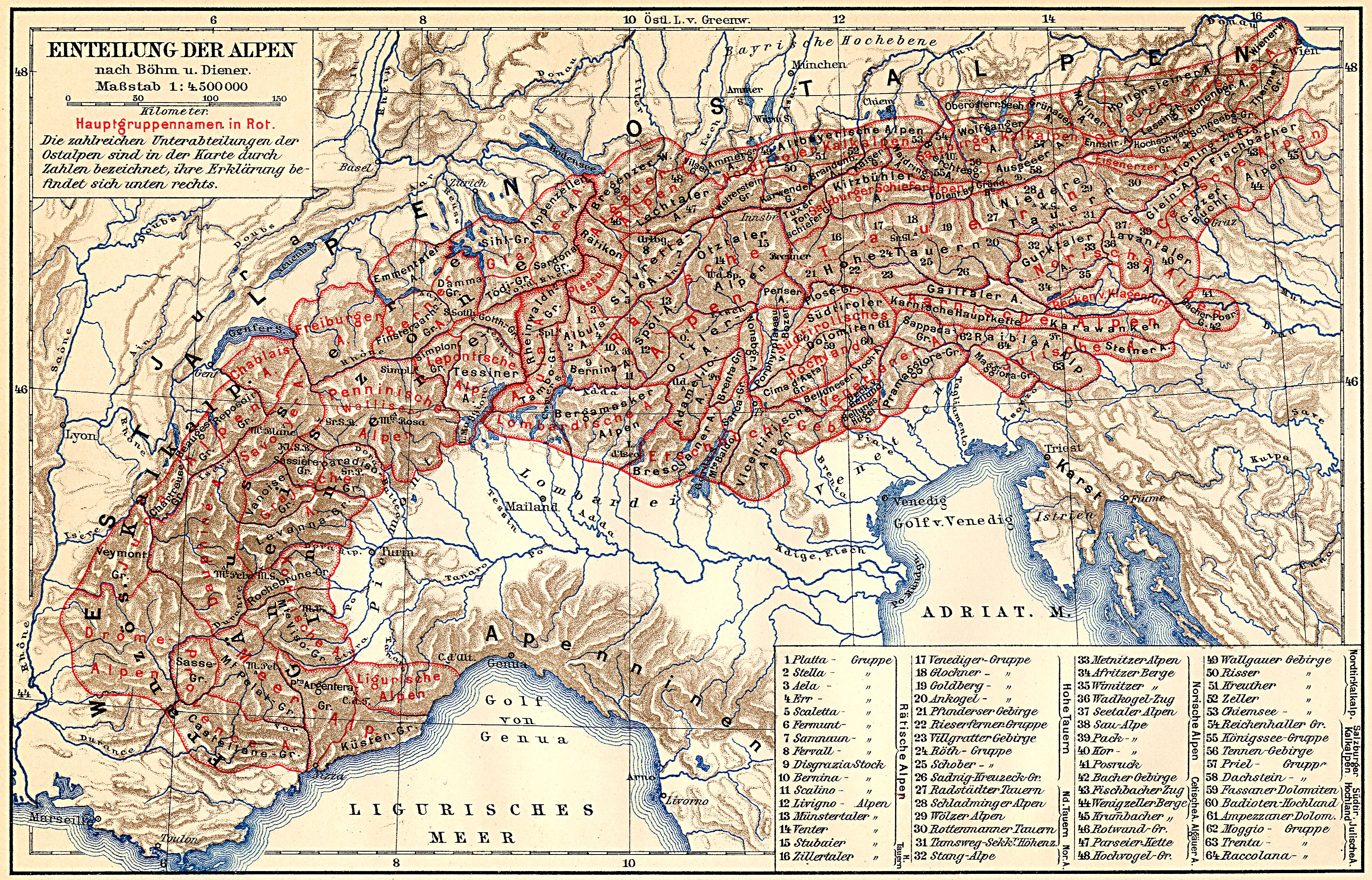
- ↑ Alps . Geographical division of the Alps. In: Meyers Großes Konversations-Lexikon . 6th edition. tape 1 . Leipzig 1905, p. 361–369 [365] ( Online zeno.org - classification according to Böhm and Diener, Map 1: 4,500,000 ; the Hochscharte (1,679 m), the highest peak there, remains unclear, but should be at the Wallerberg summit (1,682 m)).
- ^ Meyers Großes Konversations-Lexikon (Ed.): Salzburg . tape 17 , 1909, [1]., Pp. 499-500 ( online Zeno.org).
- ↑ for example: Norbert Fuchs, Erich Tuscher, Friedrich Deutsch, Walter Ellerböck: Expert opinions and suggestions regarding the flight accident with the Robin DR400 / 180R motorized aircraft [...] on the Schartenkogel, St. Jakob in Haus, Tyrol, 1250 m MSL. o. D., Section 1.1 Flight history , p. 4 ( pdf ), versa.bmvit.gv.at
- ^ A b Hubert Trimmel : Mountain group structure for the Austrian cave directory . Ed .: Association of Austrian Speleologists. Vienna 1962.
- ↑ Waidring Alps. In: Brockhaus' Kleines Konversations-Lexikon . 5th place = Leipzig edition. 2nd volume, 1911, pp. 942 ( zeno.org ).
- ↑ Alexander Tollmann : Tectonic map of the Northern Limestone Alps . Part 2: The middle section . In: Geological Society in Vienna (ed.): Releases the Geol.Ges.iW . 61st volume. Vienna 1968 ( pdf , uibk.ac.at). pdf ( Memento of the original from March 6, 2014 in the Internet Archive ) Info: The archive link was inserted automatically and has not yet been checked. Please check the original and archive link according to the instructions and then remove this notice.
- ↑ Pillersee mountain railway
- ↑ http://tirol.orf.at/news/stories/2599454/ 30 meter high cross on a mountain top, ORF.at from August 22, 2013