
Kaiser Mountains
| Kaiser Mountains | |
|---|---|
 Location of the Kaiser Mountains (highlighted in yellow) within the Eastern Alps |
|
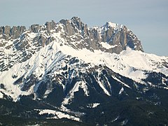
 Outline of the Kaiser Mountains, view from the northwest |
|
| Highest peak | Ellmauer Halt ( 2344 m above sea level ) |
| location | Tyrol , Austria |
| part of |
North Tyrolean Limestone Alps, Northern Eastern Alps |
| Classification according to |
AVE : 8 SOIUSA : II / B-21.VI |
| Coordinates | 47 ° 34 ' N , 12 ° 18' E |
| surface | 298.8 km² |
The Kaisergebirge is a mountain group of the Northern Limestone Alps in the Eastern Alps . It is located in Austria in the state of Tyrol between Kufstein and St. Johann in Tirol . The Kaisergebirge consists of two distinctive mountain ranges , the Wilder Kaiser and the Zahmer Kaiser with the Niederkaiser upstream to the southeast . It is one of the most famous mountain groups in the Eastern Alps and is of great importance for climbers and mountaineers as well as hikers. The largest part of the Kaisergebirge is a nature reserve and is neither accessible by roads nor by cable cars .
structure
The Kaiser mountains is divided into the predominantly consisting of bare limestone Wilden Kaiser and the north side thereof located on the south side and predominantly with mountain pine covered (flops) Zahmen Kaiser . Both mountain ranges are connected by the 1580 m high Stripsenjoch and are separated from each other in the west by the Kaisertal and in the east by the Kaiserbachtal . In the southeast, the Kaiser Mountains are closed off by the significantly lower and less alpine-oriented Niederkaiser, which is in front of the eastern part of the Wilder Kaiser.
In total, the Kaiser Mountains extend around 20 km in an east-west direction and around 14 km in a north-south direction. This results in a total area of approx. 280 km². The Zahme Kaiser only barely exceeds the 2000 meter limit ( Vordere Kesselschneid ). The highest elevation of the Wilder Kaiser is the Ellmauer Halt in the municipality of Ellmau with 2344 m . In addition, there are about forty other summits, including many famous climbing mountains such as the Karlspitzen that Totenkirchl , the butcher , the Christa Tower , the pulpit , the Goinger Halt , the farmer pulpit that Ackerlspitze that Maukspitze , the Zettenkaiser which Scheffauer that Kopfkraxen , the Sonneck and the Kleine Halt .

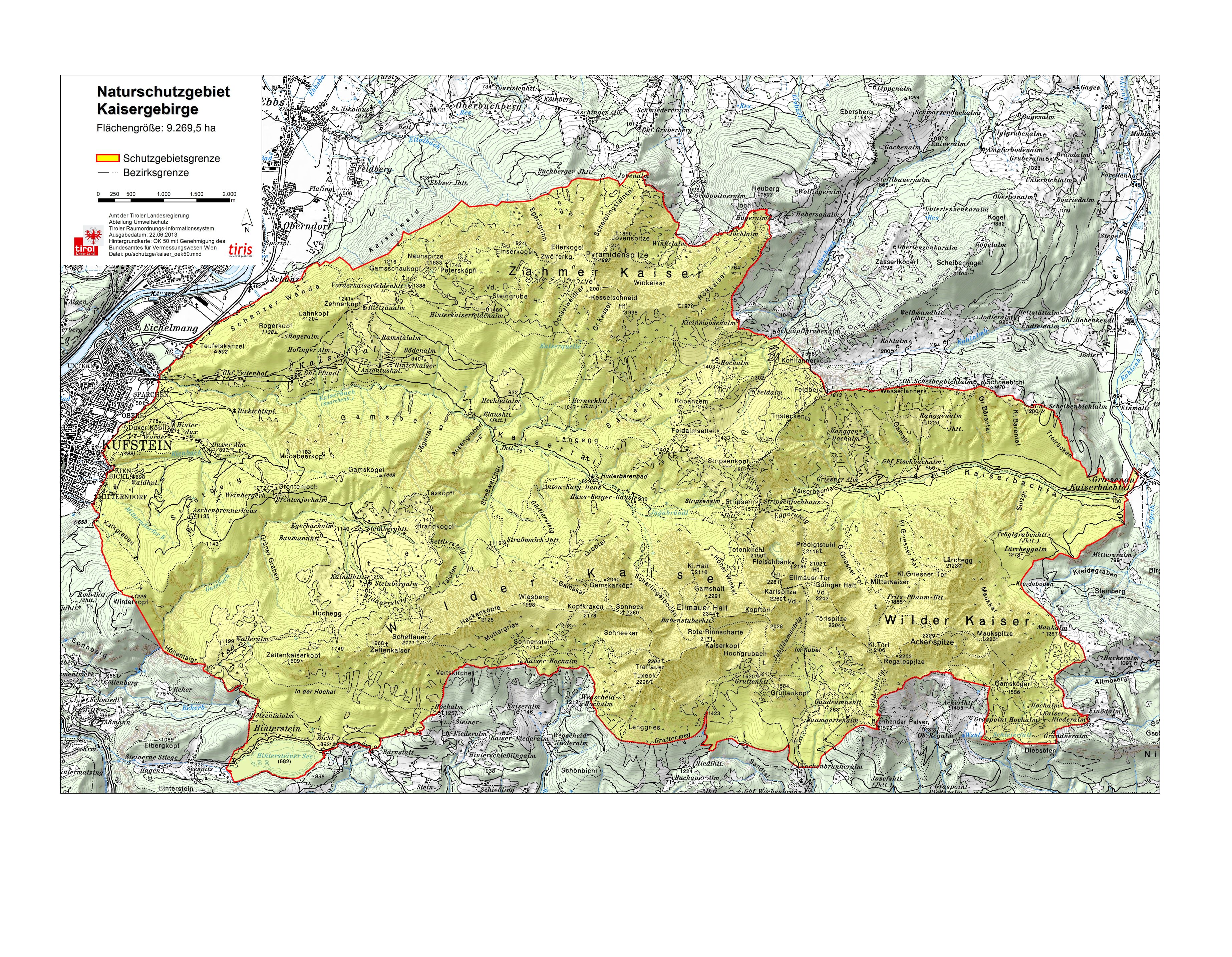
Kaisergebirge nature reserve
As early as the 1920s, individual nature lovers, including the “Emperor Pope” Franz Nieberl , called for greater protection of the unique natural area of the Kaiser Mountains. The primary goal of this protection should be to prevent over-development of the Kaisergebirge by cable cars and roads. At that time, such considerations were unsuccessful. In 1961, after a referendum, it was decided to set up a nature reserve , which was officially opened on April 19, 1963.
The Kaisergebirge nature reserve , which includes all the peaks of the Wilder and Zahmer Kaiser, has a size of 102 km² and is located on the areas of the communities of Kufstein, St. Johann in Tirol, Ebbs , Ellmau , Going , Kirchdorf in Tirol , Scheffau and Walchsee and extends from a height of 480 m to a height of 2344 m at the Ellmauer Halt. The only artificial ascent aid in the nature reserve is a chairlift to the Brentenjoch ( Kaiserlift Kufstein ), which was extensively renovated between August 2014 and April 2015 and resumed operation on May 1, 2015. Further lift projects were not implemented because of the nature reserve. For a long time, the construction of a road into the Kaisertal was discussed very controversially, the Kaisertal was the only inhabited valley in Austria without road connections. The Kaisertalstrasse , which now leads from Ebbs through the Annatunnel (length 813 m) into the Kaisertal, was opened on May 31, 2008. It was built as a private road by the municipality of Ebbs and may only be used by a very narrow group of authorized persons - such as residents, managers, authorities and organizations with security tasks.
The flora and fauna of the nature reserve is very rich.
In the Kaiser Mountains there are around 940 species of flowering plants, 38 species of ferns and over 400 species of moss . The mushroom and lichen stocks are also very rich with 100 and 236 different species each. Mixed forests of beech , silver fir ( Abies alba ) and Norway spruce ( Picea abies ) are often found in the forest region . In sub-mountainous area one finds also common ash ( Fraxinus excelsior ) and sycamore , in sunny areas and alder . In the alpine regions you will find typical hay meadows, as well as grasslands and pastures . In the sub-alpine areas you can find the typical dwarf shrub growth forms such as mountain pine and lashed alpine rose , as well as the rare dwarf galpenrose . There are different sedge societies ; the upholstered sedge lawns can be found up to the summit regions. Various wetlands are also present with typical vegetation.
As a product of Ice Age processes, a number of rare, sometimes endemic invertebrates can be found in the Kaiser Mountains . B. Allobobophora smaragdina (a worm ), a door snail , as well as some spiders and moth species . Typical vertebrates are alpine and fire salamanders , smooth snakes , adder (unusual color variants), dormouse , dormouse and bank vole . In higher regions you can find chamois , ermine , snow mouse and mountain hare . Typical birds are the wood warbler , the red-breasted flycatcher (for North Tyrol endemic ), Alpine Chough , Raven , Crag Martin , Willow Tit , Alpenbirkenzeisig , Alpine Accentor , Wallcreeper and Birk - Auer - and ptarmigan . At raptors come before the hawk , hawk , golden eagle , tawny owl , pygmy owl and boreal owl .
Geology and hydrology
The Kaiser belongs to the northern limestone Alps and consists mainly of Wetterstein limestone and dolomite . The Wetterstein limestone has a maximum thickness of about 1000 m, which corresponds to the maximum height of the rock fragments of the Kaiser Mountains. The younger dolomites are mainly found in the hollows of the valleys. As a remnant of the Würm Ice Age, there are extensive moraine fields. The Kaisergebirge is drained in the west by the Sparchenbach , which flows through the Kaisertal and later flows into the Inn , in the east by the Kaiserbach, which flows through the Kaiserbachtal and flows over the Kohlenbach into the Großache in the Leukental , and thus later flows into the Chiemsee , as well as in the north through the Weissenbach and in the south the area west of the so-called "Ellmauer-Tor" from the Weißache , which also flows into the Inn, and east of the "Ellmauer-Tor" ( watershed Ellmauer Tor) through the Goinger Hausbach, resp. the Rettenbach , which both flow into the Reither Ache , and thus later into the Großache and subsequently into the Chiemsee. Between the Fleischbank and the Totenkirchl there is a small Kargletscher "Schneeloch", which should soon have disappeared as the average temperature continues to rise. In the far west of the mountains is the Hintersteiner See , which is used as a bathing lake .
history
The first human settlement finds in the Kaiser Mountains go back 4,000 to 5,000 years. These are Bronze Age ceramics in the Tischofer Cave . The cave used to be visited by Stone Age hunters. This is proven by findings from Lautscher peaks , which are around 27,000 to 28,000 years old. The Tischofer Cave thus represents the oldest documented place of discovery of human products in Tyrol.
Documentary evidence of settlement in the Imperial Valley in the Middle Ages goes back to at least 1430. A purchase contract for a farm called “Hinterkaiser” dates from this year. The name "Kaiser" for the area is older and can be found in a Kitzbühel property register as early as 1240, which speaks of a "Gamsgiayt an dem Chaiser". In 1611 Matthias Burgklehner's maps include the caption "It is in the rule of Khueffstein the Kayser, a very high purge, so an imperial Cron is equal, for his sake of greatness, then also that he is far, in the Heche vil Meils Weg, as if he were round and crowned, seen. "
The tourist development begins in the Kaiser Mountains in the second half of the 19th century. Most of the documented first ascents of peaks from this period to the turn of the century are also omitted. It can be assumed, however, that most of the peaks were sporadically climbed by locals without this ever having been documented. Especially in the period from the end of the 19th century to the First World War, the limestone walls of the Wilder Kaiser were the cradle of the Munich climbing scene, in which well-known climbing pioneers such as Hans Dülfer developed completely new climbing techniques and styles. The climbing styles and techniques, which were largely developed before the First World War, were in some cases very technically fixated, and shaped climbing in the Kaiser right into the 1960s. In 1977 Reinhard Karl and Helmut Kiene introduced the “ Pumprisse ” at the meat bank to the VII degree . In the 1970s and 1980s, a number of sometimes extremely difficult sport climbing routes were opened in the Kaiser Mountains. The route “Des Kaiser's New Clothes” by Stefan Glowacz with an X + on the meat bank pillar is currently the most difficult . The history of the development of the Kaiser Mountains is one of the focal points of the exhibition in the Museum St. Johann in Tirol .
Important peaks and routes in the Wilder Kaiser
Summits and routes

|
|
Transitions

From west to east there are the following important crossings in the Wilder Kaiser to get from Sölllandl to Kaisertal or Kaiserbachtal and vice versa:
- Sattel am Scheffauer (about 2040 m above sea level ), it connects the Steiner Hochalm ( 1257 m above sea level , south side) with the Steinbergalm ( Kaindlhütte ) ( 1293 m above sea level , north side) via the Südsteig to Scheffauer and the Widauersteig (via ferrata)
- Sonneck (direct transition to about 2210 m above sea level ), it connects the Kaiser Hochalm ( 1425 m above sea level , south side) with the Anton-Karg-Haus (Hinterbärenbad) ( 829 m above sea level , north side) the Südsteig to the Sonneck and the Güttlersteig and Bettlersteig
- Rote-Rinn-Scharte ( 2099 m above sea level ), it connects the Gruttenhütte ( 1620 m above sea level , south side) with the Hans-Berger-Haus (Kaisertalhaus) ( 940 m above sea level , north side) the Gamsängersteig and the marked route through the Scharlinger bottoms
- Kopftörl ( 2058 m above sea level ), it connects the Gruttenhütte ( 1620 m above sea level , south side) with the Hans-Berger-Haus (Kaisertalhaus) ( 940 m above sea level , north side) via the Südsteig and the marked route through the Hohe Winkel
- Ellmauer Tor ( 1997 m above sea level ), it connects the Gaudeamushütte ( 1270 m above sea level , south side) with the Stripsenjochhaus ( 1577 m above sea level , north side) via the path through the Kübelkar and the Steinerne Rinne as well as the Eggersteig .
- Kleines Törl ( 2102 m above sea level ), it connects the Gaudeamushütte ( 1270 m above sea level , south side) with the Fritz Pflaum hut ( 1865 m above sea level , north side) via the Gildensteig and the Nordsteig through the Griesener Kar.
- Ackerlspitze (direct transition to about 2315 m above sea level ), it connects the Ackerlhütte ( 1455 m above sea level , south side) with the Fritz Pflaum hut ( 1865 m above sea level , north side) via the southern route via low armchair and high chair and the north gate.
The first two stages of the Adlerweg long-distance hiking trail lead along the southern slopes of the Kaiser Mountains from St. Johann in Tirol as Wilder-Kaiser-Steig over the Gaudeamushütte , Gruttenhütte , Kaiser-Hochalm and Walleralm to the Hintersteiner See .
Important peaks in the Zahmer Kaiser
Summits and routes

|
|
Transitions

From west to east there are the following important crossings in the Zahmer Kaiser to get from the Kaisertal to the Inntal , Aschenbachtal or Weißenbachtal or Kaiserbachtal or vice versa:
- Ritzaualm ( 1161 m above sea level ), it connects the Pfandlhof ( 793 m above sea level , south side) with the Gasthof Schanz ( 471 m above sea level , north side) via the Ritzaualm-Steig and the Nordsteig (Schanzerwände).
- Vogelbad ( 1860 m above sea level ), it connects the Hinterkaiserfeldenalm ( 1480 m above sea level , south side) with the Aschinger Alm ( 955 m above sea level , north side) via the steep path through the Steingrube and the Eggersgrinn .
- Pyramidenspitze ( 1997 m above sea level ), it connects the Anton-Karg-Haus ( 829 m above sea level , south side) with the Winkelalm ( 1193 m above sea level , north side) via the steep path through the Ochselweidkar and the Winkelkarsteig (Via ferrata)
- Feldalmsattel ( 1433 m above sea level ), it connects the Anton-Karg-Haus ( 829 m above sea level , west side) with the Feldalm ( 1302 m above sea level , east side) via the steep path towards Ropanzen and the steep path to Feldalm .
- Stripsenjoch ( 1577 m above sea level ), it connects the Hans-Berger-Haus ( 940 m above sea level , west side) with the Griesner Alm ( 1024 m above sea level , east side) via the climb via Neustadler-Wiese and the climb over the Wildanger and the Russnleiten .
photos
Wilder Kaiser, south side (Ackerlspitze and Maukspitze)

Wilder Kaiser, east side
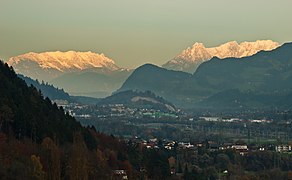
Tamer and Wilder Kaiser seen from the west

Wilder and Zahmer Kaiser seen from Kössen / north-east


Huts
- Alpine club houses: Vorderkaiserfeldenhütte , Anton-Karg-Haus / Hinterbärenbad , Stripsenjochhaus , Gaudeamushütte , Gruttenhütte , Fritz-Pflaum-Hütte , Ackerlhütte
- Friends of Nature House : Hans Berger House
- Private houses: Berghaus Aschenbrenner , Brentenjochhütte ( Weinbergerhaus ), Fischbachalm, Griesner Alm , Kaindlhütte , Pfandlhof, Riedlhütte, Ritzaualm, Veitenhof, Walleralm , Wochenbrunner Alm
Valley locations
Kufstein , Ebbs , Niederndorf , Kiefersfelden , Walchsee , Kössen , Schwendt , Kirchdorf in Tirol , St. Johann in Tirol , Going , Ellmau , Scheffau , Söll , Schwoich
Neighboring mountain groups
The Kaiser Mountains border on the following other mountain groups in the Alps:
- Chiemgau Alps (in the north)
- Loferer Steinberge (in the east)
- Kitzbühel Alps (in the south)
- Rofan Mountains (in the southwest)
- Bavarian Prealps / Mangfall Mountains (in the northwest)
Literature and map
- Fritz Schmitt: The Book of the Wilder Kaiser. Bergverlag Rother, Munich 1982, ISBN 3-7633-7238-5 .
- Pit Schubert : ( Alpine club leader extreme) Kaiser Mountains. Bergverlag Rother , 2000, ISBN 3-7633-1272-2 .
- Horst Höfler , Jan Piepenstock: ( Alpine Club Guide Alpine) Kaiser Mountains. Bergverlag Rother, 2006, ISBN 3-7633-1257-9 .
- Markus Stadler: Wilder Kaiser climbing guide. 1st edition. Panico-Alpinverlag, 2012, ISBN 978-3-936740-86-8 .
- Markus Stadler, Andrea and Andreas Strauss: Photo book Kaisergebirge. 1st edition. Bergverlag Rother, 2009, ISBN 978-3-7633-7050-4 .
- Gebhard Bendler: Wilder Kaiser. From summer visitors, climbing legends, ski pioneers and the mountain doctor. 200 years of alpine history and travel culture. Tyrolia, Innsbruck-Vienna 2016, ISBN 978-3-7022-3547-5 .
- Alpine Club Map 1: 25,000, Kaiser Mountains , sheet 8.
- Dr. Dieter Zerbes, Sedimentary System and Tectonic Formation of the Kaiser Mountains. Hieronymus Verlag Munich 2001, ISBN 3-89791-226-0 .
Web links
- Interactive 3D hiking map of the Wilder Kaiser
- Interactive map of the Tamer Kaiser
- Climbing in the Kaiser Mountains
- The Kaiser Mountains on steinmandl.de
- World Database on Protected Areas - Kaisergebirge (English)
Individual evidence
- ^ K. Fischer 1962: "Kaisergebirge" nature reserve yes or no? In: Jahrb. Ver. Protection of alpine plants and animals . No. 27 , 1962.
- ^ ARGE Wald-Landschaft-Mensch, Office of the Tyrolean Provincial Government - Department of Environmental Protection (Ed.): Kaisergebirge Nature Reserve. Nature inventory and site mapping . preliminary version. 1996.
- ↑ Kaiser Mountains. In: tiroler-schutzgebiete.at >> nature reserves. Office of the Tyrolean Provincial Government, accessed in 2011 . ;
- ↑ Map: Kaisergebirge nature reserve (ÖK50) , tirol.gv.at (jpg 1.1 MB)
- ^ Kaiserlift. kufstein.at, accessed on July 13, 2015 .

Allgäu Alps | Ammergau Alps | Bavarian Prealps | Berchtesgaden Alps | Brandenberg Alps | Bregenz Forest Mountains | Chiemgau Alps | Dachstein Mountains | Ennstal Alps | Gutenstein Alps | Hochschwabgruppe | Kaiser Mountains | Karwendel | Lechquellen Mountains | Lechtal Alps | Loferer and Leoganger Steinberge | Mürzsteg Alps | Upper Austrian Pre-Alps | Rax Schneeberg Group | Salzburg Slate Alps | Salzkammergut Mountains | Tennengebirge | Dead Mountains | Türnitz Alps | Wetterstein Mountains and Mieming Range | Vienna Woods | Ybbstal Alps

City center: Festungsberg | Calvary (or Hero's Hill) | Kinkpark | Lausbühel | Zellerberg
City frame: Kaisergebirge (with Stadtberg ) | Pendling | Kufstein Forest | Maistaller Berg | Thierberg (with Marbling )