Pyramid top
| Pyramid top | ||
|---|---|---|
|
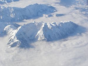
Aerial view of the top of the pyramid (center foreground) |
||
| height | 1997 m above sea level A. | |
| location | Tyrol , Austria | |
| Mountains | Tame Emperor | |
| Dominance | 0.35 km → Front Kesselschneid | |
| Notch height | 55 m ↓ notch for boiler cutting | |
| Coordinates | 47 ° 36 '37 " N , 12 ° 16' 36" E | |
|
|
||
| rock | Wetterstein lime | |
| Age of the rock | Triad | |
The top of the pyramid is 1997 m above sea level. A. high summit in the Zahmer Kaiser in Tyrol .
The pyramid peak is after the largely unknown, 2002 m high Vorderen Kesselschneid , only the second highest peak in the Zahmer Kaiser, but its most famous and most frequently climbed. To the south and west of the top of the pyramid stretches a karstified, mountain plateau overgrown with mountain pines , which slopes partly steeply into the Kaisertal and sends a long ridge with several peaks to Kufstein . To the north, the Jovenspitze is separated by a notch . To the northwest, the top of the pyramid falls steeply and steeply over the Eggersgrinn, to the northeast it breaks off with cliffs into the Winkelkar.
Routes
From the west, the Pyramidenspitze can be reached from the Vorderkaiserfeldenhütte via a long but rewarding path that leads past Naunspitze ( 1633 m ), Petersköpfl ( 1745 m ) and Einserkogel ( 1924 m ) and without any difficulties to the summit cross of the Pyramid tip leads. The northern route with the starting point in Durchholzen is more demanding . This path is no problem up to Winkelkar, from there a via ferrata (A / B) leads to the summit, walking time a total of 3 hours in the ascent. In some cases, there is also a considerable risk of falling rocks. The fuses have been renewed and are currently in the best condition (September 2009); According to the notice on the hut, the fuses are currently (January 2013) defective.
Web links
Individual evidence
- ^ Bavarian Geological State Office, 1998, Geological map of Bavaria with explanations 1: 500,000
- ^ Federal Office for Metrology and Surveying Austria: Austrian Map online (Austrian map 1: 50,000) .

