Petersköpfl
| Petersköpfl | ||
|---|---|---|
|
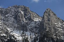
The northern falls of the Petersköpfl from the Naunspitze |
||
| height | 1745 m above sea level A. | |
| location | Tyrol , Austria | |
| Mountains | Tame Emperor | |
| Dominance | 0.2 km → Einserkogel | |
| Notch height | 10 m ↓ Scharte to Einserkogel | |
| Coordinates | 47 ° 36 '34 " N , 12 ° 14' 48" E | |
|
|
||
The Petersköpfl is 1745 m above sea level. A. high summit in the Kaiser Mountains in the state of Tyrol in Austria . The Petersköpfl is located in the area of the Zahmer Kaiser. In the east the Petersköpfl is connected to the Einserkogel by a ridge, in the west it is separated from the Naunspitze by a notch . To the south it falls steeply into the Kaisertal, to the north with steep rock faces towards Ebbs . In the east follows a moderately inclined, mountain pine-covered high plateau, which forms the main ridge of the Zahmer Kaiser and extends to the top of the pyramid .
Ascents
The Petersköpfel can be easily reached in an hour from the Vorderkaiserfeldenhütte , as well as from the Hinterkaiserfeldenalm. The transition to the neighboring Naunspitze takes twenty minutes. A path leads from Petersköpfl over the Zahmer Kaiser plateau to the top of the pyramid . A few short climbing routes lead through a small rock slab on the western flank. Longer alpine climbing routes also lead through the northern falls.


