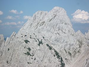
Lärchegg
| Lärchegg | ||
|---|---|---|
|
Lärchegg (left) from the west with normal route (right Hintere Gamsflucht) seen from the Mitterkaiser main summit |
||
| height | 2123 m above sea level A. | |
| location | Tyrol , Austria | |
| Mountains | Kaiser Mountains | |
| Dominance | 0.3 km → Hintere Gamsflucht | |
| Notch height | 123 m ↓ Northern Griesschartl | |
| Coordinates | 47 ° 34 '9 " N , 12 ° 21' 5" E | |
|
|
||
| Normal way | from the Kleiner Griesner Tor via the marked and partly insured path ( II ) | |
|
Lärchegg from the north, to the right the Hochkar Kleines Griesener Tor , in front the Kaiserbachtal with Fischbachalm (left) and pine oil distillery (right) |
||
|
Lärchegg summit from the west, the north summit on the left, the main summit on the right |
||
The Lärchegg (also Lärcheck or Lärcheggspitze ) is a 2,123 meter high mountain in the Kaiser Mountains in the northern Limestone Alps .
location
The Lärchegg forms the mighty north-east pillar of the Wilder Kaiser and rises with 1200 meter high rockfalls directly above the Kaiserbachtal . It belongs to the impressive backdrop of the Eastern Emperor and is a slender rock pyramid when viewed from all sides. In the south, the higher peaks Ackerlspitze and Maukspitze join. The mountain belongs to the municipality of Kirchdorf in Tirol .
In front of the Lärcheck on its northeast ridge is the 1950 m high Lärchecknadel , also called Kaisermandl , which can only be climbed via difficult climbing routes (from V).
Routes
The normal route to the Lärchegg is demanding and should not be underestimated. Only experienced mountaineers with a good physical condition, surefootedness, a head for heights and climbing agility can dare to climb.
The starting point is the pine oil distillery (900 m) in the Kaiserbachtal between the Fischbachalm and the Griesner Alm (parking spaces on the toll road from Griesenau ). The signposted path climbs steeply to the Kleine Griesner Tor , a scree cirque . There, marked with a large stone man (but without a signpost), turn-off to the left into the long scree ridge east upwards; the ascent leads south to the Fritz Pflaum hut . From the junction to the summit there are only sparse, partly very faded (as of 2015) markings and a constant risk of falling rocks . On initially good footsteps, marked with cairns, roughly in the middle of an extremely steep, unstable scree field up to 1850 meters on the rock walls of the summit structure. From there, continue uphill on poor, steep tracks in the scree, to the entrance to the left crossing out of the scree field at around 1905 m (Steinmann, red marking). There the trail leads out of the cirque and initially continues in a left crossing , often exposed to steep tracks, over craggy terrain , ledges and steep gullies. The distinctive gully is crossed and on the left side of this on the newly created path (partly difficulty level I) upwards until a long, partly very exposed, wire rope passage (difficulty B / C) leads up to the ridge, from where the notch leads to climbing tracks (partly I) between the south and main peaks is reached. From there about 30 meters over the north ridge up to the summit cross (II and climbing tracks). Allow 3 hours for the entire ascent, while this route takes 2.5 hours for the descent.
An unsecured, unmarked alternative route also leads from the Kleiner Griesener Tor all the way up the scree field to the southern Griesschartl , which is reached via crags , scree and rocks (I-II). From there over the southwest ridge or to the left of it over rocks, ribbons and a chimney up to the summit cross (II, but only if the route is optimally found, otherwise much more difficult, sometimes very exposed). The route is difficult to find from the saddle and requires a good sense of direction.
The only base nearby is the Fritz-Pflaum-Hütte , from which you descend to the Kleine Griesner Tor and reach Lärchegg after a total of 2 hours.
Literature and map
- Horst Höfler , Jan Piepenstock: Alpine Kaiser Mountains. Alpine Club Guide for hikers and mountaineers (= Alpine Club Guide ). 12th edition. Bergverlag Rother, Munich 2006, ISBN 3-7633-1257-9 .
- Pit Schubert : Extreme Kaiser Mountains. Alpine club guide for climbers (= Alpine club guide ). Bergverlag Rother, Munich 2000, ISBN 3-7633-1272-2
- Alpine Club Map 1: 25,000, Kaiser Mountains , sheet 8.


