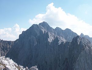
Chamois escapes
| Chamois escapes | ||
|---|---|---|
|
Rear (left) and Vordere Gamsflucht (right) from the southwest |
||
| height | 2203 m above sea level A. | |
| location | Tyrol , Austria | |
| Mountains | Kaiser Mountains | |
| Dominance | 0.2 km → Ackerlspitze | |
| Notch height | 43 m ↓ Scharte to Ackerlgrat | |
| Coordinates | 47 ° 33 '48 " N , 12 ° 20' 57" E | |
|
|
||
| rock | Wetterstein lime | |
| Age of the rock | Ladinium - Lower Carnium | |
| Normal way | Vordere Gamsflucht via the lower part of the Nordsteig Ackerlspitze and then traverse and over the ridge to the summit (III-), Hintere Gamsflucht from the Kleiner Griesener Tor over the Schuttkar to the southern Griesschartl and from there over a channel, a notch and the north ridge to the summit (II) | |
|
Vordere (left) and Hintere Gamsflucht (right) seen from the north from Lärchegg |
||
|
Front (left) and rear Gamsflucht (right), seen from the east from the Maukspitze |
||
The Gamsfluchten are a mountain in the Kaiser Mountains in Tyrol that has two peaks. The Bergstock consists of the northern Hinterer Gamsflucht ( 2140 m above sea level ) and the southern higher Vorderen Gamsflucht ( 2203 m above sea level ). Both peaks belong to the municipality of Kirchdorf in Tirol .
location
The Gamsfluchten rise immediately north of the Lärchegg as a central part in the ridge direction south to the Ackerlspitze and are thus in the eastern part of the Kaisergebirge (Ostkaiser). To the west is the Mitterkaiser , in between is the Hochkar Kleines Griesener Tor . They are separated from Lärchegg by the southern and northern Griesschartl. Towards the Ackerlspitze there is a steep heel with a notch immediately after the summit of the Vorderen Gamsflucht towards the south. Both peaks have a distinctive ridge course in a north-south direction with a few ridge towers, they fall to the east and west in steep rockfalls into the Kleine Griesner Tor (west side) and in 600 meter high walls towards the chalk pit (east side).
Routes
The rock is partly rotten and often brittle, so the peaks are rarely visited. Both peaks can only be reached by climbing, alpine experience, surefootedness, a head for heights, good physical condition, a sense of direction and climbing skills are therefore required. There are no marked or secured routes (no hooks) leading to the summit. The only base is the Fritz Pflaum Hut .
The summit of the Hinteren Gamsflucht requires unsecured climbing in the second degree of difficulty according to the UIAA scale . First you climb out of the Kaiserbachtal or from the Fritz-Pflaum-Hütte to the Kleiner Griesener Tor and then continue on the marked route towards Lärchegg . Where this route leaves the large, steeply rising Schuttkar to the north, you continue to climb up to the southern notch (Südliches Griesschartl). From there it goes down eastwards and over Grasschrofen to the south you reach a gorge-like channel over which you reach the north ridge. After a traverse on the west side, one arrives over the ridge to the summit with the summit book. Time required from the Kleiner Griesener Tor around 2 hours.
The Vordere Gamsflucht requires unsecured climbing in the III. Difficulty level on the UIAA scale (III-). The entry point is in the lower part of the Nordsteig from the Griesener Kar to the Ackerlspitze. The Nordsteig can be reached either via the Große Griesener Tor via Fritz-Pflaum-Hütte or via the Kleiner Griesener Tor from the Kaiserbachtal. You leave the marked route up to the Ackerlspitze on the east side, where the route begins to form a clear path with bends in the Grasschrofen area. After crossing a gully, you cross partly on steep tracks on grasschrofen and ascending through gullies to the connecting ridge, which runs from the Ackerlspitze over to the Vorderen Gamsflucht. Along the ridge, ridge towers on the east side, you immediately reach the saddle in front of the summit. There over a plate, through a chimney and over a ribbon to the lower summit and further through a notch to the summit.
There are other, more difficult climbing routes on both mountains, but these are very rarely used.
Literature and map
- Horst Höfler , Jan Piepenstock: Alpine Kaiser Mountains. Alpine Club Guide for hikers and mountaineers (= Alpine Club Guide ). 12th edition. Bergverlag Rother, Munich 2006, ISBN 3-7633-1257-9 .
- Pit Schubert : Extreme Kaiser Mountains. Alpine club guide for climbers (= Alpine club guide ). Bergverlag Rother, Munich 2000, ISBN 3-7633-1272-2
- Alpine Club Map 1: 25,000, Kaiser Mountains , sheet 8.


