
Kaiserbach
|
Kaiserbach Sparchenbach |
||
 Schematic map of the course of the Kaiserbach / Sparchenbach |
||
| Data | ||
| Water code | AT : 2-8-258 | |
| location | Tyrol , Austria | |
| River system | Danube | |
| Drain over | Inn → Danube → Black Sea | |
| source |
Stripsenjoch in the Kaiser Mountains 47 ° 34 ′ 39 ″ N , 12 ° 18 ′ 23 ″ E |
|
| Source height | 1422 m above sea level A. | |
| muzzle | In Kufstein in the Inn Coordinates: 47 ° 36 ′ 0 ″ N , 12 ° 10 ′ 41 ″ E 47 ° 36 ′ 0 ″ N , 12 ° 10 ′ 41 ″ E |
|
| Mouth height | 477 m above sea level A. | |
| Height difference | 945 m | |
| Bottom slope | 81 ‰ | |
| length | 11.7 km | |
| Catchment area | 34.3 km² | |
| Discharge at the Kufstein gauge (ÖBK) A Eo : 34 km² Location: 600 m above the mouth |
NNQ (28.12.2006) MNQ 2002–2009 MQ 2002–2009 Mq 2002–2009 MHQ 2002–2009 HHQ (12.08.2002) |
28 l / s 320 l / s 1.39 m³ / s 40.9 l / (s km²) 28 m³ / s 45.7 m³ / s |
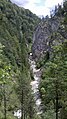
The Kaiserbach or Sparchenbach is a river in the Kaiser Mountains in the Tyrolean Unterland ( Austria ). It rises at about 1400 m above sea level. A. at Stripsenjoch , runs west through the Kaisertal and flows into the Inn at Kufstein / Sparchen .
The Kaiserbach was important for forestry until the beginning of the 20th century . Felled logs were pulled from numerous forest slopes in the side valleys of the Kaisertal down to the stream. At several barrages of Kaiserbach was dammed. When the locks were subsequently opened, a strong current was created, with which the collected logs could be transported down to Kufstein in several stages.
The barrages were called Klausen and the timber transport was called Trift . Today only the main Trift Klause as a restored collecting basin at the creek bed, as well as the associated Klaushütte , which previously served as workers' accommodation , are preserved.
Most of the stream forms the municipal boundary between Kufstein and Ebbs .
gallery
Kaiserbach near the climb to the Tischofer cave

The main drift hermitage


See also
The Kaisertalbach (also called Kaiserbach) rises on the eastern side of the Stripsenjoch and flows through the Kaiserbachtal in an easterly direction and flows into the Kohlenbach at Griesenau .
Web links
Individual evidence
- ↑ a b c d TIRIS - Tyrolean spatial information system
- ↑ Federal Ministry for Agriculture, Forestry, Environment and Water Management (ed.): Hydrographisches Jahrbuch von Österreich 2009. 117th volume. Vienna 2011, p. OG 114, PDF (12.1 MB) on bmlrt.gv.at (yearbook 2009)