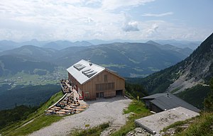
Gruttenhütte
| Gruttenhütte DAV hut category I |
||
|---|---|---|
|
New Gruttenhütte (2019) |
||
| location | South side of the Wilder Kaiser; Tyrol , Austria ; Valley location: Ellmau | |
| Mountain range | Kaiser Mountains | |
| Geographical location: | 47 ° 33 '12 " N , 12 ° 18' 39" E | |
| Altitude | 1620 m above sea level A. | |
|
|
||
| owner | DAV - Section Turner-Alpen-Kränzchen | |
| Construction type | hut | |
| Usual opening times | Early June to mid October | |
| accommodation | 85 beds, 18 camps | |
| Winter room | 0 bearings | |
| Web link | Gruttenhütte | |
| Hut directory | ÖAV DAV | |

The Gruttenhütte is an alpine club hut of the Turner-Alpen-Kränzchen section of the German Alpine Club in the Kaiser Mountains in Tyrol .
location
The hut is located on the south side of the Wilder Kaiser on a grassy ledge high above Ellmau and Going with a good view that extends as far as the Großvenediger on a clear day . The heavily frequented base is dominated by the Ellmauer Halt , the highest peak in the Kaiser Mountains at 2344 m . On beautiful summer days, the Gruttenhütte is a popular destination for hikers and an important starting point for mountaineers and climbers, who can go on numerous alpine tours to the peaks of the Wilder Kaiser from here.
history
The Gruttenhütte was built at its current location in 1899 by the Turner-Alpen-Kränzchen and Carl Babenstuber section and officially opened on July 14, 1900. Soon a glass veranda, a wash house and a multi-stable were built. In 1922 a separate sleeping house, the Josef-Dorn-Haus, was built and in 1925, the then hut manager Hans Eisenmann created a climbing system through the Wilde Gschloß, today's Jubiläumssteig. In 1938 another extension, renovation and expansion took place, and another bedroom was built , the Emil-Kempfle-Haus . During the Second World War, the Gruttenhütte was confiscated and remained closed until 1951 after the opening of the border there was a strong rush to Tyrol. This was followed by major renovation and expansion measures in the 1960s. Even after a new spring version, the productivity hardly increased, and shortly before the 100th birthday an elaborate sewer was completed. This not only ensures the water drainage and supply, but also the supply of electricity and telephone to the hut. In 2002 the sanitary facilities were modernized and a wooden terrace was built.
New hut construction 2017
The hut was fundamentally rebuilt and modernized in the 2017 season. Since then, the hut has a capacity of 103 overnight stays. As part of the modernization, new sanitary facilities, showers for guests, smaller overnight accommodation units, drying rooms and seminar rooms have been implemented. The main building received an extension and new terraces, the two old side houses were completely dismantled.
getting there
By car from Kufstein via Scheffau or coming from Salzburg via Lofer and St. Johann in Tirol to Ellmau . There branch off to the north and finally via a toll road up to the Wochenbrunner Alm ( 1080 m ) with a large car park.
Approaches
- From Wochenbrunner Alm on the designated hut path to the hut in around 1½ hours (540 meters in altitude).
- From Ellmau or Scheffau via the Riedlhütte and the road to the hut in 2½ hours (800 meters in altitude).
- From Going via the Gaudeamushütte and the Klamml, a steep rock channel, in 3 hours (800 meters in altitude).
Transitions
- Gaudeamushütte ( 1270 m ) over the Klamml, medium, walking time: ¾ hour
- Kaindlhütte ( 1318 m ) via Wilder-Kaiser-Steig, Walleralm and Hochegg, easy, walking time: 5 hours
- Hans-Berger-Haus or Anton-Karg-Haus via Kopftörl and Hohen Winkel, difficult, walking time: 4 hours
- Hans-Berger-Haus or Anton-Karg-Haus via Rote-Rinn-Scharte and Scharlinger Boden, difficult, walking time: 4 hours
- Stripsenjochhaus ( 1577 m ) via Jubiläumssteig (helmet and gloves required, surefootedness required), Ellmauer Tor and Steinerne Rinne, difficult, walking time: 3½ hours
- Fritz-Pflaum-Hütte ( 1865 m ) via the Jubiläumssteig, Gildensteig and Kleine Törl , difficult, walking time: 5 hours
- Ackerlhütte ( 1460 m ) via Jubiläumssteig and Wilder-Kaiser-Steig, medium, walking time: 3 hours
- Babenstuberhütte ( 2300 m ), walking time: 2½ hours
Mountaineering
- Ellmauer Halt ( 2344 m ), walking time: 2½ hours
- Treffauer ( 2304 m ), walking time: 3 hours
- Short stop ( 2116 m ), walking time: 3½ hours
- Karlspitzen ( 2281 m ), walking time: 2½ hours
- Goinger Halt ( 2193 m ), walking time: 2 hours
- Numerous climbing routes, for example on the Kopftörlgrat
cards
- Alpine Club Map Sheet 8 Kaiser Mountains (1: 25,000)
Web links
- Gruttenhütte (1620m). In: Section Turner-Alpen-Kränzchen. Retrieved April 17, 2017 .
Individual evidence
- ↑ Alpine Club Maps of the Eastern Alps. Retrieved October 6, 2019 .


