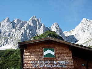
Ackerlhütte
| Ackerlhütte ÖAV self-catering hut category I |
||
|---|---|---|
| location | south of the Ackerlspitze ; Tyrol , Austria ; Valley location: Going | |
| Mountain range | Wilder Kaiser | |
| Geographical location: | 47 ° 32 '58 " N , 12 ° 20' 28" E | |
| Altitude | 1455 m above sea level A. | |
|
|
||
| owner | Kitzbühel section | |
| Construction type | Self-catering hut | |
| Usual opening times | Supervised on weekends from June to October | |
| accommodation | 0 beds, 14 camps | |
| Web link | ÖAV Kitzbühel | |
| Hut directory | ÖAV DAV | |
The Ackerlhütte is an Alpine Club hut of the Kitzbühel section of the Austrian Alpine Club in the Wilder Kaiser . It is located at an altitude of 1455 m above sea level. A. (according to other information 1456 m or 1465 m ) below the south walls of Regalmspitze , Ackerlspitze and Maukspitze . It is a self-catering hut with 14 camps that serves as a base for mountaineers and climbers. From June to September, the Ackerlhütte is supervised at least on weekends, otherwise it is not open (only accessible with an AV key ).
Ascent
- From Hüttling / Prama (near Going ) via Graspoint-Niederalm and Schleier waterfall in 2 hours.
- From Wochenbrunner Alm via Gaudeamushütte and Höhenweg in 2 hours.
- From St. Johann in Tirol via the Adlerweg, here Wilder-Kaiser-Steig in 3 hours.
Transitions
- Gaudeamushütte ( 1270 m ) via Wilder-Kaiser-Steig, walking time: 1.5 hours
-
Fritz Pflaum Hut ( 1865 m )
- over Ackerlspitze, difficult, walking time: 5.5 hours
- Via Wilder-Kaiser-Steig, Gildensteig and Kleine Törl , walking time: 3.5 hours
- Gruttenhütte ( 1620 m ) via Wilder-Kaiser-Steig and Jubiläumssteig, medium, walking time: 3 hours
Mountaineering
- Maukspitze ( 2231 m ) in 2.5 hours
- Ackerlspitze ( 2329 m ) in 3 hours
- Western Hochgrubachspitze ( 2277 m ) in 2.5 hours
- Regalmspitze ( 2253 m ) in 3.5 hours
Web links
Individual evidence
- ^ Austrian map 1: 50,000
- ↑ according to section
- ↑ as posted at the hut

