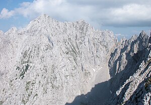
Karlspitzen
| Karlspitzen | ||
|---|---|---|
|
Vordere (left) and Hintere Karlspitze (right) - view from the summit of the Hinteren Goinger Halt (in the background Ellmauer Halt ) |
||
| height | 2281 m above sea level A. | |
| location | Tyrol , Austria | |
| Mountains | Kaiser Mountains | |
| Dominance | 1 km → Ellmauer Halt | |
| Notch height | 223 m ↓ Kopftörl | |
| Coordinates | 47 ° 33 '56 " N , 12 ° 18' 56" E | |
|
|
||
| rock | Wetterstein lime | |
| Age of the rock | Upper upper anisium - Lower Carnium | |
| First ascent | touristic on June 14, 1875 by Carl Babenstuber and Georg Hofmann with guide Johann Schlechter (Mallhansl) | |
| Normal way | Ellmauer Tor - Karlspitzen | |
|
Hintere (left) and Vordere Karlspitze (right) from the west - view from the summit of the Gamshalt , on the far left the meat bank, on the right the Kopftörl , the Kopftörlgrat and below the Hohe Winkel |
||
The Karlspitzen form a double-peaked mountain in the Kaiser Mountains in Tyrol . Your double summit consists of the northern 2281 m above sea level. A. high Hinteren Karlspitze and the southern 2260 m high Vorderen Karlspitze with summit cross . The two peaks are connected by a sharp, exposed rock ridge; seen from the south, the Vordere Karlspitze is a striking, huge boulder, while the Hintere Karlspitze is hidden behind other (lower) neighboring mountains.
location
The Karlspitzen rise immediately to the west of the Ellmauer Tor and the Steinerne Rinne and are thus in the central part, in the heart of the Wilder Kaiser, so to speak. To the east, the lower Goinger Halt and the Predigtstuhl rise . The Fleischbank and Totenkirchl adjoin the Karlspitzen directly to the north , while further west, separated by the Kopftörl and the Kopftörlgrat, the higher Ellmauer Halt rises. Thanks to its location, the Karlspitzen offer great views both over the Wilder Kaiser and the neighboring mountain groups.
Climbs
The Karlspitzen are among the less visited and difficult to reach imperial peaks. No marked or secured route leads to the double summit, rather mountain experience, a sense of direction and safe climbing ability as well as a head for heights are required here.
The normal route begins at Ellmauer Tor , first leads up a steep scree field on steep tracks and is marked with numerous red or blue spots of color from the beginning of the rocks (as of August 2015). In addition, the climbing tracks are usually easy to recognize, after a long rock channel and traversing a large, steeply sloping scree field through a rugged rock face , they lead largely steep and often exposed with easy climbing up to the second degree of difficulty according to the UIAA scale (the most difficult parts are through Iron clips disarmed) to the ridge of the Karlspitzen in just over an hour.
There the route branches to the Hinteren (15 minutes) and Vorderen Karlspitze (30 minutes). The ridge itself is sometimes very narrow and there are numerous climbing points with difficulty level I, occasionally also short sections II (Vordere Karlspitze), the routes sometimes switch to the west side.
There are several well-known climbing routes on the Vorderen Karlspitze, for example. B. on the west / south-west ridge (III).
A descent to the Fleischbankscharte is possible from the Hinteren Karlspitze (II).
Literature and map
- Horst Höfler , Jan Piepenstock: Alpine Kaiser Mountains. Alpine Club Guide for hikers and mountaineers (= Alpine Club Guide ). 12th edition. Bergverlag Rother, Munich 2006, ISBN 3-7633-1257-9 .
- Pit Schubert : Extreme Kaiser Mountains. Alpine club guide for climbers (= Alpine club guide ). Bergverlag Rother, Munich 2000, ISBN 3-7633-1272-2
- Alpine Club Map 1: 25,000, Kaiser Mountains , sheet 8.
Web links
Individual evidence
- ^ Heinrich Schwaiger: The Kaiser Mountains. In: The development of the Eastern Alps , Volume I, DOeAV publishing house, Berlin 1893


