
Chamois halt
| Chamois halt | ||
|---|---|---|
 The Gamshalt above the Obere Scharlinger Boden from the south, seen from the Sonneck |
||
| height | 2291 m above sea level A. | |
| location | Tyrol , Austria | |
| Mountains | Kaiser Mountains | |
| Dominance | 0.3 km → Ellmauer Halt | |
| Notch height | 25 m ↓ Scharte to Elmauer Halt | |
| Coordinates | 47 ° 33 '52 " N , 12 ° 18' 0" E | |
|
||
| rock | Wetterstein lime | |
| Age of the rock | Triad | |
| Normal way | Kaiserschützensteig ( B / C and I ) | |
 Kleine Halt , Gamshalt and Ellmauer Halt (from left) from the Treffauer |
||

The Gamshalt is a 2291 m above sea level. A. high mountain in the Wilder Kaiser of the Kaiser Mountains ( Northern Limestone Alps ) in Tyrol . It is the fourth highest peak in the entire Kaiser Mountains and belongs to the Haltstock .
location
The Gamshalt is upstream of the Ellmauer Halt to the north and the Kleiner Halt to the south, so it forms the middle part of the Haltstock. It slopes down on all sides with steep rock faces - except for the south side, which forms a ridge that leads to the Ellmauer Halt in the south. On the west side is the Hochkar Grüne Mulde , via which a transition to the Kleiner Halt is possible while bypassing the north face of the Gamshalt (Kaiserschützensteig). The up to 700 meter high west face above the Upper Scharlinger Boden is a destination for climbers. The east wall has a height of around 800 meters above the Hohe Winkel . On the west side opposite is the Sonneck , on the east side the Karlspitzen . The peak belongs to the municipality of Kufstein .
The base for tours on this mountain are the Anton-Karg-Haus and Hans-Berger-Haus in the Kaisertal . The mountain was first climbed by A. Bonnet and B. Schlechter (called Mallhansl) on July 14, 1880 on the occasion of a descent from the Ellmauer Halt.
Routes
The easiest access to the summit is a via ferrata , the Kaiserschützensteig . It has the difficulty B / C and I +, several places require effort. It is long, strenuous and technically demanding. It is much more sparsely insured than usual via ferratas and exposed (long passages even in steep terrain without a wire rope, only sparsely defused by iron stirrups). In addition, there is a considerable approach and a large difference in altitude to master from the deep Kaisertal . Starting points are the Anton-Karg-Haus and the Hans-Berger-Haus . The Kaiserschützensteig is scenic and crosses all three peaks of the Haltstock: Kleine Halt, Gamshalt and Ellmauer Halt, whereby Kleine Halt and Gamshalt can also be bypassed (each branch with a branch to the summit). It offers impressive views. A good 3 hours ascent from the start (Oberer Scharlinger Boden) without a detour to the peaks of Kleiner Halt and Gamshalt, with these peaks around 1.5 hours longer. Access to the entrance from the Hans-Berger-Haus 1.5 hours, alternatively from the Gruttenhütte via Rote-Rinn-Scharte in 2.5 hours to the entrance. Surefootedness and a head for heights as well as climbing skills required, as well as helmet, via ferrata set and climbing harness. Very well marked:
- Access from the Obere Scharlinger Boden to the summit of the Kleine Halt: Follow the Kaiserschützensteig, which branches off and begins on the east side of the Obere Scharlingerboden from the marked path that leads up from the Kaisertal to the Rote-Rinn-Scharte. First it goes up the past before the via ferrata crosses up and down to the left into the green gully. This goes up to its upper end without safety, where the Stichsteig branches off to the summit of the Kleine Halt. Continue straight on towards Ellmauer Halt on the right side into the rock channel and traverse it diagonally upwards and immediately cross the north-west face of the Gamshalt over further gaps, strips, ledges, walking terrain and rock steps over to the east into the Green Mulde (Hochkar with grass chaff) and up over it to a prominent rock below the ridge. Here branch to the summit of the Gamshalt and via this route keep left up to the ridge and over this to the summit with Steinmann (passages I, without safety devices). Time required from Oberer Scharlinger Boden about 2.5 hours.
- Access from the summit of the Ellmauer Halt to the summit of the Gamshalt: Follow the Kaiserschützensteig, which begins below the Ellmauer Halt summit cross, initially slightly downwards towards the north, later on or on the west side of the north ridge towards Gamshalt, to the junction to the Gamshalt. From there, see above. Time required about 45 minutes. It should be noted that the Kaiserschützensteig is more difficult to climb on the descent than on the ascent.
On the south side below the Green Mulde there are some climbing routes, the entry of which in the Upper Scharlinger Boden is reached by the marked route that leads from the Hans-Berger-Haus to the Rote-Rinn-Scharte.
photos
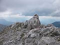
Summit of the Gamshalt

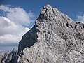
Summit construction of the Gamshalt from the south, seen from the Treffauer
Gamshalt from the north, seen from the summit of the Kleine Halt
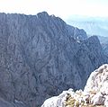
East face of the Gamshalt, seen from the Hinteren Karlspitze , in front of it the Hohe Winkel below , on the right the Kleine Halt

Hochkar Green Mulde on the south side of the Gamshalt (Kaiserschützensteig)

Route to Gamshalt (left) above the junction from the main route of the Kaiserschützensteig


Literature and map
- Horst Höfler , Jan Piepenstock: Alpine Kaiser Mountains. Alpine Club Guide for hikers and mountaineers (= Alpine Club Guide ). 12th edition. Bergverlag Rother, Munich 2006, ISBN 3-7633-1257-9 .
- Pit Schubert : Extreme Kaiser Mountains. Alpine club guide for climbers (= Alpine club guide ). Bergverlag Rother, Munich 2000, ISBN 3-7633-1272-2 .
- Alpine Club Map 1: 25,000, Kaiser Mountains , sheet 8.
Web links
Individual evidence
- ^ Bavarian Geological State Office, 1998, Geological map of Bavaria with explanations 1: 500,000