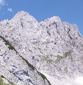
Hochgrubach peaks
| Hochgrubach peaks | ||
|---|---|---|
|
Eastern (left) and western Hochgrubachspitze (right) from the north-west. |
||
| height | 2284 m above sea level A. | |
| location | Tyrol , Austria | |
| Mountains | Kaiser Mountains | |
| Dominance | 0.1 km → Ackerlspitze | |
| Notch height | 25 m ↓ notch to Ackerlspitze | |
| Coordinates | 47 ° 33 '31 " N , 12 ° 20' 43" E | |
|
|
||
| rock | Wetterstein lime | |
| Age of the rock | Ladinium - Lower Carnium | |
| First ascent | June 19, 1881 by Gottfried Merzbacher and Michael Soyer from Going | |
| Normal way | Via the marked route from the south to the western Hochgrubachspitze, from there unmarked transition to the eastern Hochgrubachspitze (II) | |
|
Summit of the western (left) and eastern Hochgrubachspitze from the southwest |
||
The Hochgrubachspitzen are a mountain in the Kaiser Mountains in Tyrol and belong to the mountain range of the Ostkaiser. They have two peaks and consist of the western Hochgrubachspitze ( 2277 m above sea level ) and the higher eastern Hochgrubachspitze ( 2284 m above sea level ). The mountain belongs to the municipality of Kirchdorf in Tirol .
location
The Hochgrubach peaks rise immediately west of the Ackerlspitze south of the Kleiner Griesener Tor and are thus in the eastern part of the Kaisergebirge. To the west of it are the Regalmturm and the Regalmspitze . To the south the mountain falls into the Sölllandl . To the north, high, steep rock faces drop into the Griesener Kar, while the south side has high rock faces.
Routes
The ascent of the Hochgrubach peaks is demanding and requires a long ascent, which requires good physical condition, a sense of direction, a head for heights, surefootedness and climbing skills.
The western Hochgrubachspitze can be reached via a difficult, sometimes very exposed, marked route (the markings are partly very faded, status: 2015), which begins on the Wilden-Kaiser-Steig west of the Ackerlsporn (Steinmann) and first traverses a scree field ascending to the west , before it goes up into a ravine exposed over steep grass beds, which is then crossed and left on the east side past a small "cave". The further ascent leads over steep grass ridges and a short rock channel (which can also be bypassed to the east), partly also on path tracks to the east past the Schönwetterfensterl , where the rocky summit ridge (I-II) is reached, via which the summit cross (with book) is reached becomes. Time required around 3 hours.
The eastern Hochgrubachspitze is even more challenging and accessible from both the west and the east:
- From the west: You first climb the Westliche Hochgrubachspitze via the normal route, but shortly before the summit turn left following the ridge in the direction of Ackerlspitze and descend into the notch between the two Hochgrubach peaks (partly Grasschrofen, partly rock) and climb from there to the summit the eastern Hochgrubachspitze, avoiding a steep drop on the north side (entire transition II, partly very airy). Time required approx. 30 minutes from the summit of the western Hochgrubachspitze.
- From the east: Coming from the south, first climb the Ackerlspitze and from there descend about 70 meters in altitude on the Nordsteig in the direction of Kleines Griesener Tor (or climb from the north from the Kaiserbachtal in the direction of the Ackerlspitze on a marked, difficult mountain path) before ascending directly west to the ridge , over which one then immediately reaches the summit, partly on the south side (without summit cross); this variant is also exposed; it also requires unsecured climbing in the II degree of difficulty according to the UIAA scale . Time required approx. 45 minutes from the summit of the Ackerlspitze.
In winter, the western Hochgrubachspitze can be climbed from the Kaiserbachtal via the Großer Griesener Tor and the Schönwetterfensterl (very challenging).
A popular climbing route in III. Grad leads over an approach branching off from the normal route and over the southwest ridge to the summit of the western Hochgrubachspitze. A well-known climbing route on the eastern Hochgrubachspitze is the southern edge (Rigelekante, V).
Literature and map
- Horst Höfler , Jan Piepenstock: Alpine Kaiser Mountains. Alpine Club Guide for hikers and mountaineers (= Alpine Club Guide ). 12th edition. Bergverlag Rother, Munich 2006, ISBN 3-7633-1257-9 .
- Pit Schubert : Extreme Kaiser Mountains. Alpine club guide for climbers (= Alpine club guide ). Bergverlag Rother, Munich 2000, ISBN 3-7633-1272-2
- Alpine Club Map 1: 25,000, Kaiser Mountains , sheet 8.
Web links
- Tour description with pictures Western Hochgrubachspitze
- Tour description with pictures Eastern Hochgrubachspitze
Individual evidence
- ^ Heinrich Schwaiger: The Kaiser Mountains. In: The development of the Eastern Alps , Volume I, DOeAV publishing house, Berlin 1893


