
Leukental
| Leukental | ||
|---|---|---|
 Leukental with the Wilder Kaiser |
||
| location | Tyrol , Austria | |
| Waters | Great thing | |
| Mountains | Kitzbühel Alps , Kaiser Mountains , Loferer and Leoganger Steinberge , Chiemgau Alps | |
| Geographical location | 47 ° 33 ' N , 12 ° 27' E | |
|
||
| height | 600 to 1200 m above sea level A. | |
| length | 40 km | |

The Leukental , in the local dialect Leikntoi , is a valley in North Tyrol in the Kitzbühel district and in its foothills as far as Reit im Winkl in Upper Bavaria .
Location and landscape
The Leukental runs from south to north from the Thurn Pass to the Bavarian border, but is not clearly delimited as a river valley, but also includes some smaller side valleys and the Kaiserwinkl region . The main river through the Leukental is from its origin at Pass Thurn to Kitzbühel as Jochberger Ache , from Kitzbühel to St. Johann in Tirol as Kitzbühler Ache , from the confluence with the Fieberbrunner Ache at St. Johann in Tirol as Großache and from the Talenge at Erpfendorf also referred to as Kössener Ache through the Hagertal section . After leaving Tyrol, the river in Bavaria from the border town of Schleching to its confluence with the Chiemsee between Übersee and Chieming is called Tiroler Achen , the Achental valley .
Municipalities in the Leukental are: Jochberg , Aurach bei Kitzbühel , Kitzbühel , Oberndorf in Tirol , St. Johann in Tirol , Kirchdorf in Tirol and Kössen as well as the Bavarian Reit im Winkl from Kössen up the valley ( Kaiserwinkl ) , in a broader sense also those in the smaller side valleys local communities of Schwendt , Going am Wilden Kaiser , Reith bei Kitzbühel and Kirchberg in Tirol , which, with its location at the transition to the Brixental, is part of both valleys.
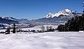
The Leukental in winter
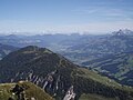
Leukental from the Gampenkogel , taken towards the north. St. Johann in Tirol and the Kitzbüheler Horn are also visible


history
The first traces of human settlement in the Leukental can be found in the cremation graves from the Urnfield era on Lebenberg near Kitzbühel from around 1300 to 1100 BC. Around 1000 to 800 BC, the Illyrians operated a Bronze Age mining center on the Kelchalpe near Aurach , and in the 4th century BC there are Celtic traces - probably from the tribes of the Ambisonts and Alums - relating to copper mining in the Kitzbühel area and Point out Jochberg. Already at this time a mule track led through the valley, which was of national importance as a connection from Italy via the Felbertauern to southern Germany. The discovery of a rag ax from the Bronze Age near Kössen and ceramic finds in Kirchdorf attest to the early use of this old trade route.
From the 2nd century BC, the Leukental belongs to the western foothills of the Celtic kingdom of Noricum . In 15 BC the Romans conquered the Alpine region and the Leukental now belongs to the Roman province of Noricum. From Roman times, only one villa rustica from the 2nd to the early 3rd century on the site of today's parish church of Kirchdorf in Tirol has been documented.
After the fall of the Western Roman Empire (476), the area became part of the Ostrogoth Empire during the migration of peoples and the immigration of the Bavarian tribe in the 6th / 7th centuries. Century to the Duchy of Bavaria . The people of the Leukental were evangelized by messengers of faith from Salzburg and the original parish of St. Johann was founded. This originally comprised the entire valley until the parish of Kirchdorf was founded in the 11th century for the pastoral care of the northern valley area.
The Leukental is mentioned for the first time in a document in a forged document from Emperor Heinrich IV for the Rott Monastery from 1073 as "Liuchental" . In the document for the establishment of the Diocese of Chiemsee from the year 1216, the Leukental is described in its expansion: "per montem qui dicitur strokes, et per vallem que vocatur Leuchental claudendo parrochias Chirchdorf et sancti Johannis usque in summitatem montis Jochperch" (translation: "about the mountain called Streichen and through the valley called Leukental, including the parishes of Kirchdorf and St. Johann up to the height of the Jochberg mountain ” ). The strike is on the Bavarian-Tyrolean border near Schleching , the name Jochberg at that time meant the Thurn pass .
The name of the valley is derived from the noble family of Liuching , who built up a county in the Leukental in the early Middle Ages and goes back to a Bavarian tribal leader named Liucho . The castle called Leukenstein near St. Johann in Tirol is no longer preserved today. From 1166 the Counts of Neuburg-Falkenstein appear as owners of the Grafschaft im Leukental ( "cometiam in Liuchental" ), and after their male line extinction in 1272, the Leukental is no longer awarded as a fief by the Bavarian duke , but administered by its officials. Due to the relocation of the court seat from Leukenstein Castle to the city of Kitzbühel in 1297, there is no longer any talk of the county in Leukental, but increasingly of the rule of Kitzbühel, from which today's Kitzbühel district emerged.
Concept history
The name Leukental originally referred to the valley floor around St. Johann and Kirchdorf, from Oberndorf to Erpfendorf. Over the centuries, the spellings have also been found: Leuchental, Liuchental, Luichental or Leoggenthal . The name would almost have been forgotten in the 20th century, as the name Großachental became common from the middle of the 19th century . This is due to the fact that at the time of the Imperial and Royal Monarchy all crown lands were precisely measured and the surveyors, who mostly came from Bohemia, often did not fully understand the Alpine dialects or entered some names on the maps without further research. In addition, many rivers in the area change their names. The valleys characteristic of this limestone part of the Alps, which enclose the limestone stocks, often show poorly concise valley watersheds. Therefore, the rivers that run in it sometimes have different names. This explains the erroneous change in the name of the valley from the name of the river. When asked what the river was called, the surveyor's answer was: “This is the great Ache”, and since this river had a different name in each village, the name Großachental was an obvious one. This historically incorrect designation can still be found in many maps today. Another peculiarity in the naming is the designation Hagertal for that section of the Leukental which separates the Kaiser Mountains from the Chiemgau Alps between Erpfendorf and Kössen .
In the course of the 20th century, the erroneous opinion arose that the Leukental would lead from the Inntal near Wörgl via Söll, Scheffau and Ellmau, the Sölllandl , to St. Johann, because the train station near Bruckhäusl ( Wörgl urban area ) until a few years ago Had the name Söll-Leukental . When the station was built in 1875, this meant that one would continue from this station to Söll and then via Ellmau into the Leukental. In the course of the decades it has become more common to believe that the Leukental leads from Wörgl via the Sölllandl to St. Johann.
The Kitzbühel local history researcher Peter Brandstätter, who died in November 2008, gave the Leukental its name back by campaigning for the elucidation of this mistake throughout his life and strengthening awareness of the Leukental again through publications and letters to the responsible public authorities. He even managed to get the ÖBB to change the name of the station from Söll-Leukental to Bruckhäusl .
Today the term has been re-established in regional geography, that is the name of the planning association 32 Leukental , it includes the communities Jochberg, Aurach bei Kitzbühel, Kitzbühel, Oberndorf in Tirol, St. Johann in Tirol, Kirchdorf in Tirol and Kössen. In terms of local politics, Kirchberg is more oriented towards the Brixental ( Brixental - Wildschönau planning association ). Although geographically part of the Leukental, the Bavarian Reit im Winkl is one of the Bavarian Achental communities, even if its municipality is not located on the Bavarian Tiroler Ache .
literature
- Josef Bichler: Wacht und Wehr - To the older name and settlement history of the Leukental. In: Tiroler Heimatblätter 1936 No. 2, p. 59 ff
- Otto Stolz : On the oldest history of the Leukental. In: Tiroler Heimatblätter 1932, No. 9/10, p. 131 ff
- Josef Egger : Development of the dishes in German Tyrol. In: Mittheilungen des Institut für Österreichische Geschichte, 4th supplement, p. 386 ff
- Dietmar Assmann: The development of the cultural landscape of the Kitzbühel area , in: Stadtbuch Kitzbühel, Volume 1, Kitzbühel 1967, p. 85 ff
Web links
- Leukental . In: Tirol Atlas , Geographie Innsbruck (Institute for Geography, University of Innsbruck)
- Province of Tyrol: Planning Association 32 - Leukental (with maps and statistics on the region)
Individual evidence
- ↑ Kirchberg in Tirol (Land Tirol). In: Tirol Atlas. Geography Innsbruck, accessed in 2011 .
- ↑ Martin Bitschnau , Hannes Obermair : Tiroler Urkundenbuch, II. Department: The documents on the history of the Inn, Eisack and Pustertal valleys. Volume 1: By the year 1140 . Universitätsverlag Wagner, Innsbruck 2009, ISBN 978-3-7030-0469-8 , p. 220-221, no. 248 .
- ^ Elisabeth Noichl : Rott am Inn . Konrad Verlag, 1983, p. 10–12 (erroneously gives the year 1084) .
- ↑ Entry on Leukental in the Austria Forum (in the AEIOU Austria Lexicon ). Also recorded in the ÖK . Leukental , detail , austrianmap.at