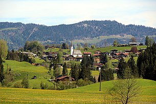
Schwendt
|
Schwendt
|
||
|---|---|---|
| coat of arms | Austria map | |
|
|
||
| Basic data | ||
| Country: | Austria | |
| State : | Tyrol | |
| Political District : | Kitzbühel | |
| License plate : | KB | |
| Surface: | 30.83 km² | |
| Coordinates : | 47 ° 38 ' N , 12 ° 24' E | |
| Height : | 702 m above sea level A. | |
| Residents : | 857 (January 1, 2020) | |
| Population density : | 28 inhabitants per km² | |
| Postal code : | 6385 | |
| Area code : | 05375 | |
| Community code : | 7 04 18 | |
| NUTS region | AT335 | |
| Address of the municipal administration: |
No. 2 6385 Schwendt |
|
| Website: | ||
| politics | ||
| Mayor : | Richard Dagn | |
|
Municipal Council : (2016) (11 members) |
||
| Location of Schwendt in the Kitzbühel district | ||
 Schwendt, seen from the south |
||
| Source: Municipal data from Statistics Austria | ||
Schwendt is a municipality with 857 inhabitants (as of January 1, 2020) in the Kitzbühel district in Tyrol ( Austria ). The community is located in the judicial district of Kitzbühel .
geography
Schwendt is located on the foothills of the Kaisergebirge in the so-called Kaiserwinkl in the Kohlental, through which the Kohlenbach flows. The highest elevation in the municipality is the Feldberg at 1813 m .
Community structure
|
structure
|
||||||
|
Legend for the breakdown table
|
Neighboring communities
Kirchdorf in Tirol , Kössen , Walchsee
history
The place name is derived from "schwenden" (clearing). A rag ax found in the municipality of Schwendt points to the 8th century; The place was first mentioned in a document around 1180 in the tradition book of the Raitenhaslach monastery as "Swentǒwe" and "Swentǒe" , while the district Kohlental already appears in 1151 as "Cholental" in a certificate of ownership for the Rott am Inn monastery . At that time the important pass route down to Kössen was already here , over the pass Klobenstein, towards Aschau in Bavaria , and Schwendt functioned as a small trading place.
In the Middle Ages , mining was also carried out in Schwendt . Lead and iron were found in the surrounding areas . The mining was stopped towards the end of the 19th century.
Today Schwendt is a small rural tourist town . The proximity to Kössen has strongly influenced the place.
Population development

tourism
Together with Kössen , Walchsee and Rettenschöss, Schwendt is part of the Kaiserwinkl holiday region .
Culture and sights
Honorary citizen
- Anton Leitner, former mayor of Schwendt
- 2017: Sebastian Haunholter (* 1950), Mayor of Schwendt 1992–2016
Web links
- 70418 - Schwendt. Community data, Statistics Austria .
Individual evidence
- ↑ Martin Bitschnau , Hannes Obermair : Tiroler Urkundenbuch, II. Department: The documents on the history of the Inn, Eisack and Pustertal valleys. Volume 2: 1140-1200 . Universitätsverlag Wagner, Innsbruck 2012, ISBN 978-3-7030-0485-8 , p. 279-280, no. 755 .
- ↑ Martin Bitschnau, Hannes Obermair: Tiroler Urkundenbuch, II. Department: The documents on the history of the Inn, Eisack and Pustertal valleys. Volume 1: By the year 1140 . Universitätsverlag Wagner, Innsbruck 2009, ISBN 978-3-7030-0469-8 , p. 72, no. 464 .
- ↑ https://www.mein Bezirk.at/kitzbuehel/fahrten/haunholter-wurde-ehrenbuerger-von-schwendt-d2158472.html (accessed on February 11, 2018)


