
Reith near Kitzbühel
|
Reith near Kitzbühel
|
||
|---|---|---|
| coat of arms | Austria map | |
 |
|
|
| Basic data | ||
| Country: | Austria | |
| State : | Tyrol | |
| Political District : | Kitzbühel | |
| License plate : | KB | |
| Surface: | 15.65 km² | |
| Coordinates : | 47 ° 29 ' N , 12 ° 21' E | |
| Height : | 762 m above sea level A. | |
| Residents : | 1,674 (January 1, 2020) | |
| Population density : | 107 inhabitants per km² | |
| Postcodes : | 6353, 6365, 6370 | |
| Area code : | 05356 | |
| Community code : | 7 04 14 | |
| NUTS region | AT335 | |
| Address of the municipal administration: |
Dorf 5 6370 Reith near Kitzbühel |
|
| Website: | ||
| politics | ||
| Mayor : | Stefan Jöchl | |
|
Municipal Council : (2016) (13 members) |
||
| Location of Reith bei Kitzbühel in the Kitzbühel district | ||
  |
||
| Source: Municipal data from Statistics Austria | ||

Reith bei Kitzbühel is a municipality with 1674 inhabitants (as of January 1, 2020) in the Kitzbühel district in Tyrol ( Austria ). The municipality is located in the judicial district of Kitzbühel in Brixental , in the immediate vicinity of Kitzbühel.
geography
location
Reith bei Kitzbühel is about five kilometers northwest of the district capital Kitzbühel , nestled between Bichlach and the Rauhen Kopf. The community belongs to the Leukental and forms the transition to the Brixental . The town is traversed by the Reither Ache and, like the town of Kitzbühel, is 762 m above sea level.
Neighboring communities
Ellmau , Going am Wilden Kaiser , Kirchberg in Tirol , Kitzbühel , Oberndorf in Tirol
Population development

history
The place is first mentioned in November 1125 as " Gebrichesrivt " ([Gebrichs-] Reith) and later around 1190 as " Ruote " (old clearing area) and once belonged to the manor of the Berchtesgaden monastery . At the Rerobichl and Astberg, silver and copper were mined from the 15th to the 18th century . The first church , which was already at the current church location, was consecrated in 1188. In the 15th century it was extended in the Gothic style and rebuilt in 1729 as a baroque wall pillar church.
Culture and sights
Partnerships
-
 Wetzlar ( Garbenheim district ), Hesse

Townscape

Catholic parish church hl. Aegidius

Totensagrer and cemetery walling
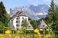
Münichau Castle


Web links
Individual evidence
- 70414 - Reith near Kitzbühel. Community data, Statistics Austria .
- ↑ In detail on this Martin Bitschnau , Hannes Obermair : Tiroler Urkundenbuch, II. Department: The documents on the history of the Inn, Eisack and Pustertal valleys. Vol. 1: Up to the year 1140 . Universitätsverlag Wagner, Innsbruck 2009, ISBN 978-3-7030-0469-8 , p. 275-276 No. 317 .
Aurach near Kitzbühel | Brixen im Thale | Fieberbrunn | Going at the Wilder Kaiser | Hochfilzen | Hopfgarten im Brixental | Itter | Jochberg | Kirchberg in Tirol | Kirchdorf in Tirol | Kitzbühel | Kössen | Oberndorf in Tirol | Reith near Kitzbühel | Schwendt | St. Jacob in House | St. Johann in Tirol | St. Ulrich am Pillersee | Waidring | Westendorf