
Jochberg (Tyrol)
|
Jochberg
|
||
|---|---|---|
| coat of arms | Austria map | |
 |
|
|
| Basic data | ||
| Country: | Austria | |
| State : | Tyrol | |
| Political District : | Kitzbühel | |
| License plate : | KB | |
| Surface: | 87.79 km² | |
| Coordinates : | 47 ° 23 ' N , 12 ° 25' E | |
| Height : | 923 m above sea level A. | |
| Residents : | 1,519 (January 1, 2020) | |
| Postal code : | 6373 | |
| Area code : | 05355 | |
| Community code : | 7 04 08 | |
| NUTS region | AT335 | |
| Address of the municipal administration: |
Dorf 22 6373 Jochberg |
|
| Website: | ||
| politics | ||
| Mayor : | Günther Resch ( FPÖ ) | |
|
Municipal Council : (2016) (13 members) |
||
| Location of Jochberg in the Kitzbühel district | ||
  |
||
| Source: Municipal data from Statistics Austria | ||

Jochberg is a municipality with 1519 inhabitants (as of January 1, 2020) in the Kitzbühel district in Tyrol ( Austria ). The community is located in the judicial district of Kitzbühel .
geography
The center of Jochberg is about halfway between Kitzbühel and the Thurn Pass , which leads to Mittersill in the Pinzgau region of Salzburg . The municipality forms the southernmost part of the Leukental and extends to the border with the state of Salzburg.
Community structure
Jochberg consists of a single cadastral community and village of the same name .
|
structure
|
||||||
|
Legend for the breakdown table
|
Districts
|
|
|
Neighboring communities
Three of the seven neighboring communities are in the Kitzbühel district, the others in the Zell am See (ZE) district.
| Kitzbühel | Aurach near Kitzbühel | |
| Kirchberg in Tyrol |
.svg)
|
Saalbach-Hinterglemm (ZE) |
| Bramberg am Wildkogel (ZE) | Mittersill (ZE) | Stuhlfelden (ZE) |
history
The area around Jochberg has been inhabited since ancient times. On the Kelchalpe near Aurach there was already around 1245 BC Chr. , A mining center. More than 40 prehistoric smelting works were found, the majority of them in the municipality of Jochberg, others in the municipality of Aurach. On the basis of archaeological finds and radiocarbon data, the melting plants are dated to the 14th / 13th centuries. Century BC (Transition from the middle to the late Bronze Age) to at least the time of the advanced urn field culture (around 1,000 BC). How long the prehistoric copper production lasted in this area is not yet clear.
Jochberg is a clearing settlement. The settlers came from the Rott am Inn monastery , who first had to make the land arable . The first written mention of the place as "Lohberg / Johberg" took place under Heinrich IV. In 1073, although the record is a diplomatic falsification of the late 12th or early century. Jochberg has been the interface between Salzburg and Bavaria since 1275 .
From the 14th century the village belonged to the Kitzbühel court . A century later, the district was immediately expanded and became a quarter . Around 1500 the character of Jochberg changed and mining was resumed. Metals like silver and copper were mined. The ore was smelted in the hamlet "Hütten". Mining was in operation in this region until 1926 and the hut until 1874.
Jochberg has been a separate village since 1762 and appears among the ten villages of the Kitzbühel Regional Court . In 1835 a road was built .
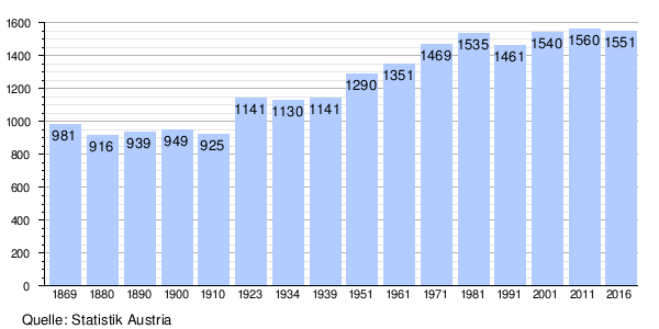
Population development
Culture and sights

- Parish church Jochberg : The baroque church, built by Kassian Singer between 1750 and 1752 , was painted in a colorful way by Simon Benedikt Faistenberger . For almost 300 years, the Wolfgang Fountain, which rises below the church, was the destination of pilgrims who sought and found healing. In a so-called “Miracle Book” from 1505, 99 cases have been handed down in writing. It is not clear why this pilgrimage to the Wolfgang spring slowly dried up. The Association of Friends of the Wolfgang Spring was founded on the initiative of Pastor Andreas Jakober. The Wolfgang water from a deep borehole can now be touched in the Gothic Wolfgang chapel in the parish church.
- Copper plate show mine.
politics
The municipal council has 13 members.
- With the municipal council elections in 2010, the municipal council had the following distribution: 4 SPÖ, 4 ÖVP, 4 FPÖ, 1 independent list.
- With the municipal council and mayoral elections in Tyrol in 2016, the municipal council has the following distribution: home list Jochberg 1, FPÖ 7, ÖVP 4, and independent list Jochberg 1.
mayor
- until 2016 Heinz Leitner (SPÖ)
- since 2016 Günter Resch (FPÖ)
coat of arms
The coat of arms of the municipality shows an ox walking to the right and refers to the altitude of the municipality and the importance of agriculture. The coat of arms of the Ochsenberg family , a noble family with a lot of property in the Jochberg district, formed the basis for the Jochberg coat of arms.
Personalities
Sons and daughters of the church
- Hias Noichl (1920–2002), cross-country skier, mountaineer and mountain guide
- Johann Grander (1930–2012), entrepreneur
Personalities associated with the community
- Ferdinand Friedensbacher (1911–1987), ski racer and ski jumper, ski school director in Jochberg 1955–1970
- Karl Koller (1919–2019), ski racer and ski instructor
Web links
- 70408 - Jochberg. Community data, Statistics Austria .
- Jochberg , in the history database ofthe association "fontes historiae - sources of history"
- Community website
- Jochberg in pictures
Individual evidence
- ↑ Martin Bitschnau , Hannes Obermair : Tiroler Urkundenbuch, II. Department: The documents on the history of the Inn, Eisack and Pustertal valleys. Vol. 2: 1140-1200 . Universitätsverlag Wagner, Innsbruck 2012, ISBN 978-3-7030-0485-8 , p. 220-221 No. 248 .
- ↑ Klaus Lewandowski: "Jochberg, Du mei Hoamat!" Jochberg homeland book. Edited by the municipality of Jochberg in Tirol, Jochberg 2001, p. 35.
- ^ Jochberg (Land Tirol) , tirolatlas, accessed on November 26, 2012
Aurach near Kitzbühel | Brixen im Thale | Fieberbrunn | Going at the Wilder Kaiser | Hochfilzen | Hopfgarten im Brixental | Itter | Jochberg | Kirchberg in Tirol | Kirchdorf in Tirol | Kitzbühel | Kössen | Oberndorf in Tirol | Reith near Kitzbühel | Schwendt | St. Jacob in House | St. Johann in Tirol | St. Ulrich am Pillersee | Waidring | Westendorf