
Hagertal
| Hagertal | ||
|---|---|---|
 Hagerbrücke |
||
| location | Tyrol , Austria | |
| Waters | Great thing | |
| Mountains | Chiemgau Alps , Kaiser Mountains | |
| Geographical location | 47 ° 37 '16 " N , 12 ° 27' 53" E | |
|
||
| height | 630 to 600 m above sea level A. | |
| length | 8 kilometers | |
| surface | 3 km² | |

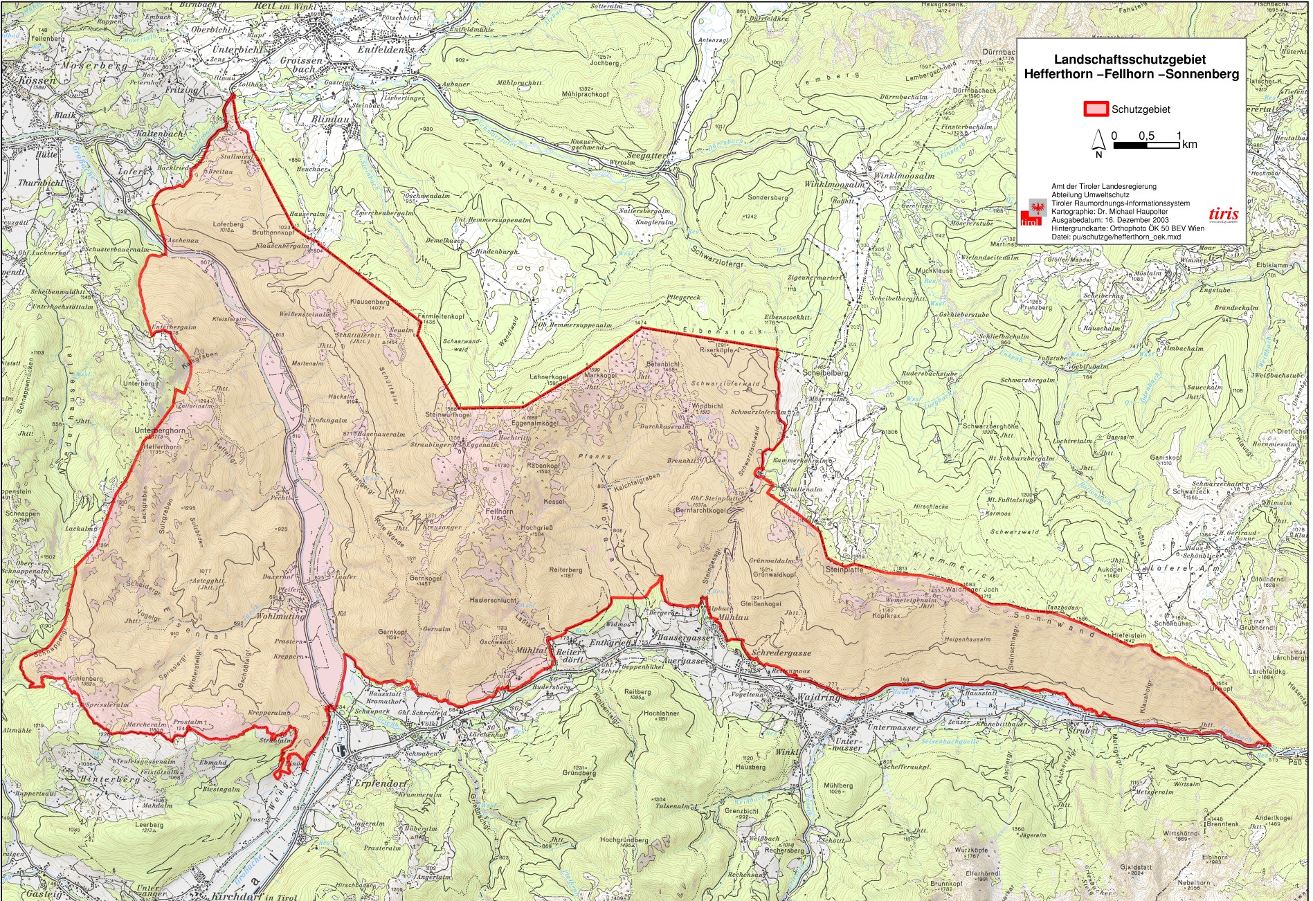
The Hagertal is a section of the Leukental and is located in the Hefferthorn-Fellhorn-Sonnenberg nature reserve in the Kitzbühel district in Tyrol . The valley is traversed by the Großache . It separates the Chiemgau Alps in the east from the Kaiser Mountains in the west.
location
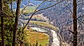
The Hagertal connects the towns of Kössen and Kirchdorf in Tirol (district of Erpfendorf ) with each other via Landesstraße 39 (Hagerstraße or Erpfendorfer Landstraße and Kössener Straße) . The L39 runs in the north on the eastern side of the valley. At the Hagerbrücke it changes over the Großache and leads to Erpfendorf on the west side of the valley.
The center of the valley is the so-called "Hager" (dialect "Hoger"), a large agriculturally used area with several alpine buildings.
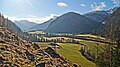
In the northern area the valley lies on Kössen municipality property, in the south it belongs to Kirchdorf in Tirol. The valley has a length of 8 kilometers and an average width of about 400 meters. The total area of the valley is about 300 hectares, it has only a slight gradient and is at the Hagerbrücke at 615 m above sea level. It is framed by the mountain ranges of the Unterberghorn ( 1773 m ) in the west and by the Chiemgau Alps with the Fellhorn ( 1765 m ) in the east. The Kirchdorf districts of Wohlmuting and Taxerau are in the southern Hagertal. The valley has been well known for decades through the Koasalauf and many national and international bike races that take place here regularly.
Waters and ditches
The Hagertal is a very water-rich area.
The Großache flows north through the valley coming from Kirchdorf. From the massif of the Unterberghorn in the west as well as from the mountain ranges of the Klausenberg and the Fellhorn in the east, water also reaches the valley via rock ditches and thus into the Großache. Some of these trenches are mostly dry and only drain the surface water. Others are water-bearing all year round.
The Brunnbach rises below the Fellhorn and passes through the Kreuzangergraben into the valley. There the brook flows two kilometers in many natural curves until it flows into the Großache. The Gänsbach rises at the Gernkopf ( 1159 m ) and also flows into the Großache. On the western side, the Unterberghorn massif is drained through several ditches. From the Lackgraben and many side ditches (Salzgraben, Schnaidergraben, Vogelgraben, Sprisslergraben, Winterstellgraben and Geschößgraben) the water flows through the Elsental into the Taxabach. The Taxaklamm testifies to the large amounts of water that have cut a gorge into the rock here. Further north, the Blahgraben, Kalkgraben, Kleislergraben and Heffertgraben, which flows through the Hörfartstal into the Pechtlbach, are to be mentioned as large inlets. The depression between the Loferberg and the Klausenberg (high valley between Tyrol and Reit im Winkl ) is drained via the Kohlhofer Gräben .
In addition to the numerous rivers, there is the Hagersee, which is fed by the groundwater flow in the valley, in the northern half of the valley.
Tourist importance
The Hagertal is a popular hiking area and starting point for many excursions to the surrounding alpine pastures and mountains ( Straubinger Haus on the Eggenalm, Hindenburghütte , Hemmersuppenalm, Durchkaseralm, Prostalm, Fellhorn). The Großache is used for rafting, canoeing and kayaking trips. The Taxaklamm is known for canyoning.
Economical meaning
The farming of the Hague Valley as an Almental has been documented for centuries. Since the flood event on June 2, 2013 , in which low-lying areas of the municipality of Kössen were flooded, the use of the Hague Valley as a retention area has been investigated.

Northern Hagertal

View to the Hefferthorn
Southern Hagertal

View from Klausenberg
Hagersee and Kleisler


Web links
Individual evidence
- ↑ Map: LSG Hefferthorn-Fellhorn-Sonnenberg (ÖK50) , tirol.gv.at (jpg 1.2 MB)
- ↑ tirisMaps . Nature conservation plan for rivers. Accessed January 12, 2015
- ↑ File: Anich 1765.jpg
- ↑ Dimension of the dams surprised. In: Tyrolean daily newspaper . Retrieved March 5, 2020 .