
Fellhorn (Chiemgau Alps)
| Fellhorn | ||
|---|---|---|
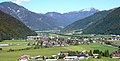
_von_Norden.jpg) Fellhorn from the north, in the background the Hohe Tauern |
||
| height | 1764 m above sea level A. | |
| location | Tyrol , Austria | |
| Mountains |
Chiemgau Alps ( AVE ) Waidring Alps ( Trimmel ) |
|
| Dominance | 4.9 km → Steinplatte | |
| Notch height | 388 m ↓ Steinplatte Chapel | |
| Coordinates | 47 ° 36 '35 " N , 12 ° 30' 31" E | |
|
||
| rock | Main dolomite , plate limestone | |
| Age of the rock | Upper Carnium - Norium | |
| Normal way | from the northwest from the Straubinger Haus on the Eggenalm | |

The Fellhorn is 1764 m above sea level. A. high mountain in the Chiemgau Alps in the municipality of Kössen , Kirchdorf and Waidring in the Tyrolean district of Kitzbühel , in Austria not far from the border with Salzburg and Bavaria . It belongs to the Hefferthorn-Fellhorn-Sonnenberg nature reserve .
Location and landscape
The municipal boundaries of Kössen , Kirchdorf and Waidring run over the summit of the Fellhorn . While the Fellhorn's slopes are dominated by wide alpine pastures in the north, the mountain has steep cliffs to the south. The mountain is known as an excellent vantage point and offers a panoramic view in particular of the nearby Loferer Steinberge , the Berchtesgaden Alps and the Steinerne Meer as well as the Kaiser Mountains . On days with good visibility, you can let your gaze wander from the Fellhorn over the main Alpine ridge with its glaciers from the Großglockner to the Großvenediger to the Olperer in the Zillertal Alps . You can also see peaks in the Bavarian Prealps , in the Karwendel and Wetterstein Mountains .
Boundary, neighboring mountain groups and classification
In the mountain group classification according to Hubert Trimmel , the group bears the number 1325 and is defined as follows:
- in the east Großache (Kössener Ache, Tiroler Achen) from Erpfendorf to the confluence with Loferbach near Lofer (municipality of Kössen) against the Unterberghorn ( 1773 m above sea level , Timmel 1321)
- in the north Loferbach / Schwarzlofer upwards (Bavarian national territory near Reit im Winkl ) to Seegatterl to the Hochgern group (Timmel 1344)
- in the northeast from Seegatterl Schwarzlofer up to the bridge 300 m south of the Schwarzloferalm - road to the Steinplatte chapel to the Dürrnbachhorn group (Timmel 1346, with the Scheibelberg , border triangle Tyrol / Salzburg / Bavaria)
- in the east at the Steinplatte chapel 150 m straight to the beginning of the Steingaßgrabenbach stream - Innerwaldbach to the federal road crossing ( Loferer Strasse B 178) at Waidring - Hausergasse to the Steinplatte ( 1869 m above sea level , Timmel 1326)
- in the south Innerwaldbach - Grießbach ( Ausserwald ) to the confluence in Großache near Erpfendorf to the limestone massif (Kirchbergstock, Timmel 1322)
The mountains to the right of the Großachental can hardly be assigned to a large group of the Alps. They are traditionally summarized as Waidringer Alps , which includes all mountains between Großache / Tiroler Ache and Saalach - but the term is relatively uncommon today. The Alpine Club division of the Eastern Alps subsumes the Fellhorn in the Chiemgau Alps group (AVE 11). According to Trimmel, it is listed as a subgroup under the subgroup with the original name Kalkalpen between Kaisergebirge and Steinernem Meer (Trimmel 1320), which is now also called Waidringer Alps , but extends west of the Großache.
geology
The Fellhornstock is formed from the main mass of the Waidring Alps and the Kaiser Mountains, from banked Dachstein limestone ( Norium to Rhätium ), in the north also plate limestone (Rhätium).
Climbing opportunities
The Fellhorn can be climbed on various routes as a technically easy and not very steep, but physically demanding hike.
- From the Seegatterl car park (780 m) on the B 305, four kilometers east of Reit im Winkl , a first route from the north leads up to the Fellhorn in around three hours. The descent for this route takes 2.5 hours. On this route you first pass the Nattersbergalm (936 m) after half an hour's walk . After about one and a half hours of walking you reach the Obere Hemmersuppenalm (approx. 1,230 m). From here it takes another hour to get to the Straubinger Haus , an alpine club hut in the Straubing section at an altitude of 1,558 meters, which is already in Tyrolean territory. From there you climb a narrow path that meanders over the grassy slopes in a south-easterly direction to the summit within 30 minutes.
- Another path, from the northwest, leads from Blindau (715 m, municipality of Reit im Winkl) via the Hindenburghütte (1,206 m) or from Blindau or Lofer (650 m, municipality of Kössen) over the Klausenbergalm (804 m) to Straubinger Haus , and from there to the Fellhorn. A walking time of 3.5 hours is estimated for this.
- A third option is from the Steinplattenhaus car park (mountain chapel), which is at an altitude of 1,375 m and can be reached via a toll road from Waidring , from the east. You circumnavigate a deep valley cut along a ridge with a beautiful view to the south and reach your destination in about 2.5 hours.
- From the southwest, from Erpfendorf in the Großachental (634 m), the path leads over the Gernkogel (1457 m) to the Straubinger Haus and from there to the summit. The total walking time of this comparatively arduous ascent is around four hours.
Exceeding Ghf. Steinplatte - Fellhorn - Lofer / Kössen is part of the Austrian long-distance hiking trail 01, the Northern Alpine Trail and the European long-distance hiking trail E4
The summit is also a popular destination for winter hikes. Due to the rather low avalanche danger, the routes over the moderately steep northern slopes from Seegatterl and Blindau are particularly suitable. Depending on the snow conditions, however, snowshoes are required here.
Also, there are of Reiterndorf (between Erpfendorf and Waidring) a riser through the Lasstal to remarkable waterfall Hasler gorge .

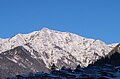
Fellhorn from the east, taken from the stone slab
Fellhorn (left) and Steinplatte (right), from Kirchdorf in Tirol , looking northeast
Fellhorn from the southeast


.jpg)
Individual evidence
- ^ Federal Office for Metrology and Surveying Austria: Austrian Map online (Austrian map 1: 50,000) .
- ^ Hubert Trimmel : Mountain group structure for the Austrian cave directory . Ed .: Association of Austrian Speleologists. Vienna 1962.
- ↑ Waidring Alps. In: Brockhaus' Kleines Konversations-Lexikon . 5th edition. 2nd volume. Leipzig 1911, p. 942 ( zeno.org ).
- ↑ Alexander Tollmann : Tectonic map of the Northern Limestone Alps . Part 2: The middle section . In: Geological Society in Vienna (ed.): Releases the Geol.Ges.iW . 61st volume. Vienna 1968 ( uibk.ac.at [PDF]). pdf ( Memento of the original from March 6, 2014 in the Internet Archive ) Info: The archive link was inserted automatically and has not yet been checked. Please check the original and archive link according to the instructions and then remove this notice.
- ↑ Bernd Riffler, Rudolf Steiger: Winter mountain tours without skis between Berchtesgaden and Allgäu. Verlag Bruckmann, Munich, 1987, ISBN 3-7654-2139-1 , p. 34.