
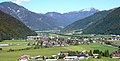
Waidring Alps
| Waidring Alps | ||
|---|---|---|
| Highest peak | Birnhorn ( 2634 m above sea level ) | |
| location | Pinzgau , Salzburg / Kitzbühel District , Tyrol | |
| part of | Northern Limestone Alps , Northern Alps | |
| Classification according to | Trimmel 1320 | |
|
||
| Coordinates | 47 ° 35 ' N , 12 ° 34' E | |

The Waidringer Alps are a mountain group of the northern Limestone Alps in Austria , between Großache (also Tiroler Achen, Kössener Ache) and Kaisergebirge in the west and the Saalach and the Steinerne Meer in the east. They extend in the Pinzgau (Zell am See district) in the northwest of the state of Salzburg and in the Kitzbühel district in the northeast of the state of Tyrol , on the border with Upper Bavaria .
The history of the concept and its classification
Like some other groups in the area (e.g. Kitzbühel, Berchtesgaden Alps), the Waidring Alps are named after the village in the middle of the group, the village of Waidring in Tyrol.
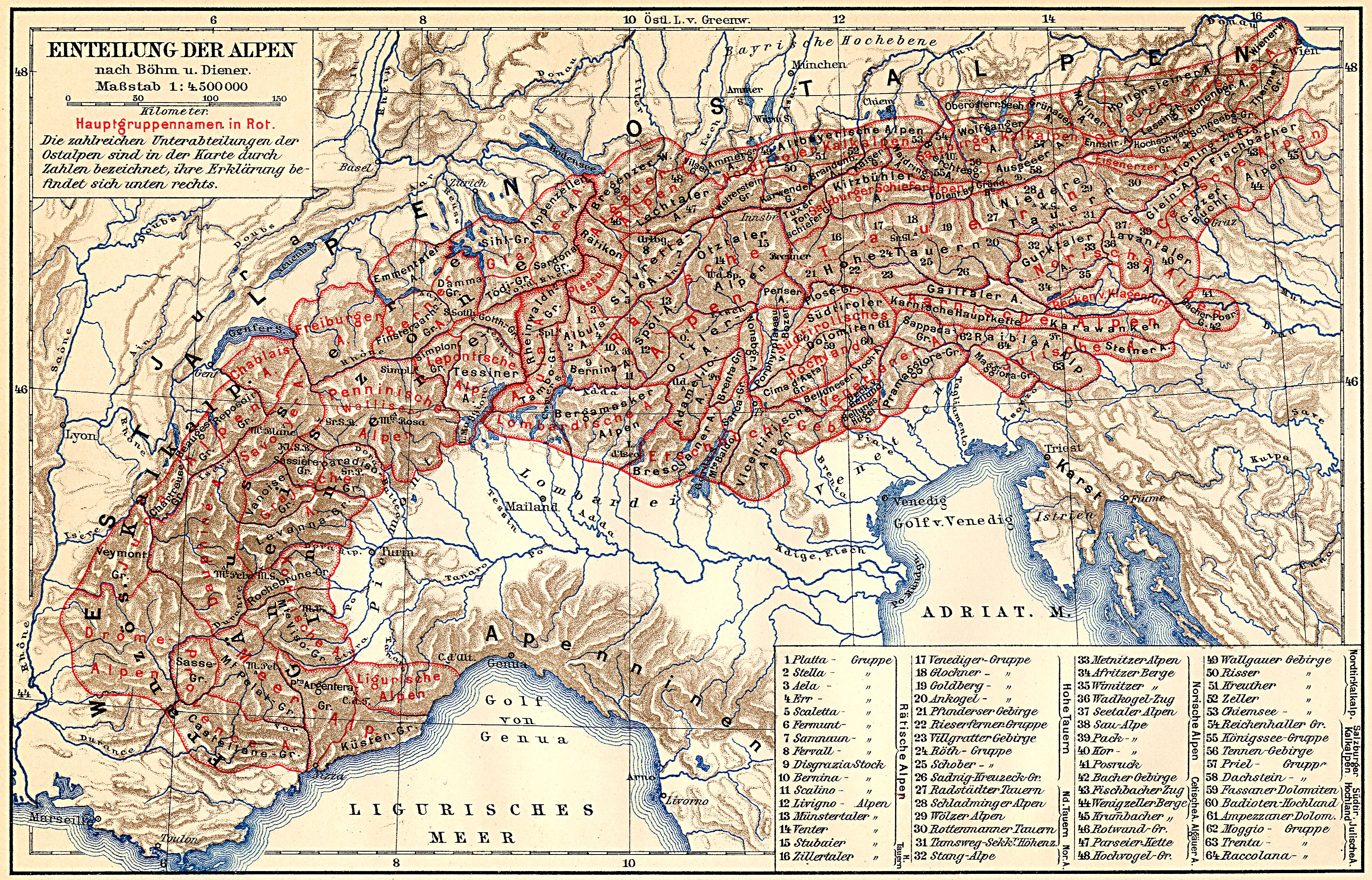
They are one of the classic, small-scale mountain divisions, and already anchored in the geography of the 19th century, and can thus be found in the division of the Eastern Alps according to Böhm from 1887 under 10.1 (or 34).
Today the term has become uncommon in general Alpine literature, but it is used in the mountain group classification according to Hubert Trimmel , which was originally published in 1962 for the Austrian cave directory and is widely used in Austrian hydrography and geology. In the first publication the group (number 1320) was called Kalkalpen between Kaisergebirge and Steinernem Meer because - contrary to the classic definition of the Großache as the western border - it also includes a group to the left of this river. After the revision of the structure in 1978, the group is again generally referred to as the Waidring Alps .
In the well-known Alpine Club division of the Eastern Alps (AVE), the southern part of the group is referred to as the Loferer and Leoganger Steinberge , the northern part of the Chiemgau Alps group, which is also managed by Trimmel .
The mountains to the left and right of the Großache in the Leukental can hardly be assigned to a large group of the Alps: In the AVE Kaisergebirge as well as Loferer and Leoganger Steinberge are inserted as comparatively very small basic groups (8, 9) between the surrounding large regions.
As a main group, the division according to Trimmel gives the North Tyrolean-Salzburg Limestone Alps (Trimmel 1300), which encompass the area between Inn and Salzach - these are also called Salzburg-Bavarian ( Limestone ) Alps or Salzburg Alps (e.g. Salzburg Northern Alps SOIUSA 24 Großache to Lammer , Salzburg Alps Partizione delle Alpi 22 Inn to Traun, Salzburger Kalkalpen Böhm 10 Großache to Enns), to the west one also speaks of the North Tyrolean Limestone Alps , for all the Limestone Alps mountains in North Tyrol up to the Salzburg and Bavarian borders or the Bavarian-Tyrolean Alps for the entire middle western limestone alpine section (around SOIUSA 21 to Großache, Böhm 9 to Saalach).
Climatically, the entire Waidring Alps are already part of the intermediate Alps .
Boundary and neighboring mountain groups
According to the mountain group structure according to Trimmel, the group is defined as follows:
- Großache in the north ( Leukental ) near Kössen - near Lofer (municipality of Kössen) up the Loferbach / Schwarzlofer (German national territory near Reit im Winkl / Traunstein district) to the bridge 300 m south of the Schwarzloferalm - road to the Steinplatte chapel - Kammerköhralm (south around the border triangle) Tirol / Salzburg / Bavaria around Scheibelberg ) - Luegbach - Unkenbach to the confluence with the Saalach near Oberrain (municipality of Unken ) to the Chiemgau Alps (1340, AVE 11), namely Hochgern group (1344, near Marquartstein to Kössen and Reit im Winkl ), Dürrnbachhorn (1346, with Scheibelberg) and Sonntagshorn group (1347)
- in the east of Saalach ( Saalachtal ) near Unken - Lofer - to Uttenhofen (near Saalfelden ) to the Salzburg Limestone Alps (1330) / Berchtesgaden Alps (AVE 10)
- in the south Leoganger Ache via Leogang - Grießenpass - Hochfilzen - Rotachenbach - near Fieberbrunn Fieberbrunner Ache to the confluence with the Großache near St. Johann in Tirol to the Kitzbühel Alps (1410, AVE 34), part of the Slate Alps
- in the west, however, the line in the western side valley is drawn to Trimmel:
Großache St. Johann iT - Kirchdorf iT - Luigambach to the creek crossing at Wirtshaus Mitterjäger - street to creek crossing at Kote 749 - creek in the direction of Kohlenbach - Kohlenbach to the confluence with the Großache near (Kössen) zum Kaisergebirge (1310, AVE 8)
This includes the Unterberghorn , which is geomorphologically quite similar to the mountains east of the Großache - according to the Alpine Association of the Eastern Alps (AVE) it is already part of the Kaiser Mountains.
Outline and landscape
The group comprises several individual limestone stocks, which are separated by the longitudinal and transverse valleys with valley watersheds that are characteristic of this area :
- Leoganger Steinberge ( Birnhorn 2634 m above sea level , Trimmel 1324) in the southeast on Saalach and Leoganger Ache, a rugged karst massif with peaks over 2000 meters
-
Loferer Steinberge ( Großes Ochsenhorn 2511 m above sea level , Trimmel 1323) north of the Saalachtal and then to Waidring with similar characteristics
. The two sticks are separated moderately by the north-east-south-west sweeping valley of the Saalachtal north-west of Weißbach near Lofer - Schidergraben - Römerbach - Römersattel - Schüttachgraben - Hochfilzen - Steinplatte (main summit 1869 m above sea level , Trimmel 1326) in the northeast, a high plateau with a south face in the east-west running Strubtal Lofer in the Saalachtal - Waidring
- Fellhorn massif (main summit 1765 m above sea level , Trimmel 1325) in the northwest, steeply south into the Ausserwald , the extended Strubtal Waidring to Erpfendorf an der Großache, to the north alpine plateaus on the Steinplatte and the Dürrnbachhorn
-
Limestone massif , also Kirchbergstock (highest peak Wallerberg 1682 m above sea level , Trimmel 1322), in the southwest from St. Johann iT to Waidring, a wooded, alpine stock with low mountain character.
Of Loferer and Leogang mountains it is in north-south direction through the Pillerseetal Waidring - Fieberbrunn separated - Buchensteinwand ( 1462 m above sea level ) in between freestanding at Hochfilzen and St. Jakob in Haus (in the Pillerseetal), through the same and the Wiesenseetal St. Jakob - Hochfilzen, freestanding, and also partly to limestone, partly to Leoganger Steinberge
- and Unterberghorn (main summit 1773 m above sea level , Trimmel 1321 - traditionally counted as part of the Kaiser Mountains) in the west to the left of the Großache, a train that stretches south-north from Kirchdorf iT to Kössen

Loferer Steinberge , from the Reiteralm from the north

Leoganger Steinberge , from the south
Fellhorn and Steinplatte , from Kirchdorf iT, view northeast over the forest

Buchensteinwand and western edge of the Kirchbergstock , view from the Steinplatte through the Pillerseetal to the south


geology
Geologically, the Waidring Alps are divided into three zones, which - contrary to the N – S / E – W grid of the valleys - graze NW – SE and make up the characteristics of the subgroups:
- the southern part with the southern limestone massif and the southwest and southern Leoganger Steinberge is formed from Wettersteinkalk ( Ladinium to Lower Carnian ), on the southern edge accompanied by Steinalm formation ( Anisium ) and Werfener layers (slate and dolomite of the Lower Triassic ) to the Haselgebirge ( Permian ), i.e. older Basement of the Kalkalpendecke, such as the southern eruptions of Kalkstein and Wallerberg and the entire Buchensteinwand
- the middle part made of main dolomite ( Carnium to upper Norium ), in the significantly higher summit corridor of the Loferer and Leoganger Steinberge with a preserved layer of Dachstein Limestone (banked, Norium to Rhätium ), against the Wetterstein there are narrow layers of Raibler ( Lower Carniola ) embedded on the southern edge
- the northeast part formed from the Unken syncline in which on the submerged Hauptdolomit - of the Tirolikum part - the younger layers of Iuvavikums are (Limes of Rhaetian , Oberalm formation , Schrambach- and Roßfeld formation ), as well as the light-colored dolomite of Saalach valley , which is part of the Hallstadt dolomite (Norium to Rhaetium). The Unkenbach as the northern border of the Waidringer Alps lies roughly in the middle of the syncline
The group shows some beautiful caves ( Prax ice cave near Maria Kirchental, Lamprechtsofen near Weißbach near Lofer, Loferer Schacht near Lofer) and is also rich in gorge ( Vorderkaserklamm , Teufelsklamm , Öfenschlucht ).
literature
Cards:
- Austrian map (ÖK) and geological map of the Republic of Austria (GÖK) 1: 50,000 sheets 91 Sankt Johann in Tirol , 92 Lofer , 122 Kitzbühel , 123 Zell am See , 124 Saalfelden (Geol. K. not published); GÖK 1: 200,000 Salzburg
Web links
- Pillerseetal bike panorama. (PDF; 469 kB) Apartments Mitterer, accessed on January 17, 2011 (painted panorama of the Waidring Alps and neighboring mountains, from the southeast).
Individual evidence
-
↑ August von Böhm : Classification of the Eastern Alps . In: A. Penck (Ed.): Geographische Abhandlungen . tape 1 . Eduard Hölzel, Vienna 1887 (1 multicolored map 1: 1,000,000). Revised Carl Diener : The Mountain Construction of the Western Alps . Tempsky / Freytag, Prague 1891.
Used for example: Alps . In: Meyers Großes Konversations-Lexikon . 6th edition. tape
1 . Leipzig 1905, [2]. Geographical division of the Alps. [Eastern Alps.] 11) The Salzburg Limestone Alps. , S. 361–369 [365] ( zeno.org - classification according to Böhm and Diener, map 1: 4,500,000 ). Salzburg . ibid. volume 17 , 1909, [1]., Pp. 499-500 [499] ( zeno.org ). - ↑ Waidring Alps . In: Brockhaus' Kleines Konversations-Lexikon . 5th edition. 2nd volume. Leipzig 1911, p. 942 ( zeno.org ). Salzburg Limestone Alps . ibid. 2nd volume, p. 599 ( zeno.org ).
- ^ Hubert Trimmel : Mountain group structure for the Austrian cave directory . Ed .: Association of Austrian Speleologists. Vienna 1962.
- ^ G. Stummer: The structure of the Austrian cave directory . In: Association of Austrian cave researchers (ed.): Wiss. Supplements to the magazine "Die Höhle" . No. 27 . Vienna 1978, p. 49-60 .
- ↑ Alexander Tollmann : Tectonic map of the Northern Limestone Alps . Part 2: The middle section . In: Geological Society in Vienna (ed.): Releases the Geol.Ges.iW . 61st volume. Vienna 1968 ( pdf , uibk.ac.at). pdf ( Memento of the original from March 6, 2014 in the Internet Archive ) Info: The archive link was inserted automatically and has not yet been checked. Please check the original and archive link according to the instructions and then remove this notice.
- ^ Tollmann: Tectonic Map . Part 2. 1968, B) Tirolikum 6. The western section of the Staufen-Höllengebirgs-ceiling , p. 145 (pdf p. 20).